METAR & TAF WSM
WSM does not publish a METAR.
Showing the nearest reporting station: PACX (COLDFOOT) · 9.4 NM away. Conditions at WSM may differ.
METAR · PACX
Observed 17:56Z
PACX 271756Z AUTO 32004KT 10SM CLR 20/09 A2978 RMK AO2 SLP712 T02000089 10206 20111 58006 $
- Wind
- 320° @ 4 kt
- Visibility
- 10 SM
- Temp / Dew
- 20°C / 9°C
- Altimeter
- 29.78 inHg
- Clouds
- CLR
- Density alt
- 2,255 ft
- Ceiling
- Unlimited
- Rules
- VFR
Airport info & contacts
Manager on record, flight service, ARTCC, attendance schedule and pattern altitude — published by the FAA and refreshed every 28 days.
Location
- From city
- 1 NM SSW
- VFR sectional
- FAIRBANKS
- ARTCC
- ZAN · ANCHORAGE
- NOTAM facility
- FAI (NOTAM-D)
Airport manager
- Name
- JEFF RUSSELL
- Phone
- 907-451-2207
- Address
- 2301 PEGER RD, FAIRBANKS AK 99709
Flight service · Hours
- FSS FAI
- FAIRBANKS907-474-07881-866-248-6516
- Attendance
- Unattended
Frequencies
Tap any row to copy the frequency to your clipboard.
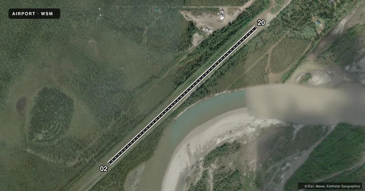
Runways & pattern
Full pagePattern entry · RWY 02
LEFT TRAFFICRunway end performance
| End | TORA | TODA | ASDA | LDA | VGSI | Approach lights | Obstruction |
|---|---|---|---|---|---|---|---|
| 02 | — | — | — | — | — | — | 32', trees, 0' from thr, 80' R of cntrln, slope 0 |
| 20 | — | — | — | — | — | — | 33', trees, 0' from thr, 74' R of cntrln, slope 0 |
Declared distances in feet. TORA = takeoff run available, TODA = takeoff distance, ASDA = accelerate-stop, LDA = landing distance.
Airport sketch
Runways drawn to scale from FAA survey coordinates, rendered over satellite imagery. Not for navigation.
Approaches & charts
Services on the field
Fuel grades, oxygen, maintenance, ramp storage and lighting — as declared to the FAA by the airport operator.
Fuel & services
- Fuel
- Not available
Ramp & ground
- Transient storage
- Tie-down
- Landing fee
- No fee published
- Customs
- Not available
- Wind indicator
- Yes
Fuel & FBOs
Cheapest 100LL and Jet A on the field and nearby. Always confirm with the FBO before taxi.
Airport notes
Surface conditions, obstructions, local procedures, lighting outages and other notes published with each FAA cycle.
General notes
- SKI PLANE OPS WINTER ONLY; SNOW REMOVAL NA.
- RWY MAINT NA; COND UNMNT; RCMND VISUAL INSP BFR LNDG.
- WX CAMERA AVBL ON INTERNET AT HTTPS://WEATHERCAMS.FAA.GOV
Runway surface & condition
- 02/20ALERT: RWY IN MT VALLEY; HIGH TRRN ALL QUADS. 35 FT TREES WI 75 FT L & R OF CNTRLN.
Approach & departure obstructions
- 02RCMD DOGLEG APCH DUE TO HILL. 48 IN SAPLINGS IN SAFETY AREA.
- 02REFLECTIVE MKRS & CONES.
- 20REFLECTIVE MKRS & CONES.
Other notes
- WINDSOCK UNRELBL.
- 02/206 IN ROCKS & 24 IN GRASS ALG SFC.
VFR map & nearby airports
VFR sectional. Tap any ICAO chip to open that airport.
Key facts · WSM
Answer card- ICAO
- WSM
- Name
- WISEMAN
- Location
- WISEMAN, ALASKA
- Elevation
- 1,195 ft MSL
- Traffic pattern altitude
- 2,195 ft MSL (1,000 AGL)
- Control tower
- Non-towered (use CTAF)
- Total runways
- 1
- Longest runway
- 02/20 · 2,000 ft
- Published ILS approaches
- 0
- Published frequencies
- 1
- Magnetic variation
- 28°
- Current flight rules
- VFR
- Current wind
- 320° at 4 kt
- Favored runway now
- RWY 02
Wiseman Airport (WSM) sits in Wiseman, Alaska at 1,195 ft MSL. It has one runway. Runway 02/20 is 2,000 ft long with a turf-dirt surface. There is no control tower. CTAF is 122.9. No ILS approaches are published here.
The pattern altitude is not published. Use standard 1,000 ft AGL unless the current Chart Supplement says otherwise. That puts the traffic pattern at 2,195 ft MSL based on the field elevation. The airport sits in a mountain valley with high terrain in all quadrants. There are 35-foot trees within 75 feet of the runway centerline on both sides. Runway 02 has reflective markers and cones. Runway 20 has the same. The windsock is unreliable. A dogleg approach is recommended for Runway 02 because of a hill. There are also 6 inches of rocks and 24 inches of grass along the surface. Ski plane operations are winter only. Snow removal is not available.
No on-field FBOs are listed. Check with the airport operator or the FBO directly by phone before arrival if you need local services. A weather camera is available online for a current look at the field. For any noise, curfew, or operational changes, verify the current FAA Chart Supplement before you go.