METAR & TAF PACX
Current METAR
Observed 01:56Z
PACX 280156Z AUTO 03007KT 10SM VCTS -RA FEW055 BKN070 OVC085 18/11 A2978 RMK AO2 LTG DSNT E TSB07RAB33 SLP714 P0000 T01830111 $
- Wind
- 030° @ 7 kt
- Visibility
- 10 SM
- Temp / Dew
- 18°C / 11°C
- Altimeter
- 29.78 inHg
- Clouds
- OVC
- Density alt
- 1,834 ft
- Ceiling
- 7,000 ft AGL
- Rules
- VFR
Airport info & contacts
Manager on record, flight service, ARTCC, attendance schedule and pattern altitude — published by the FAA and refreshed every 28 days.
Location
- From city
- 0 NM WSW
- VFR sectional
- FAIRBANKS
- ARTCC
- ZAN · ANCHORAGE
- NOTAM facility
- FAI (NOTAM-D)
Airport manager
- Name
- JEFF RUSSELL
- Phone
- 907-451-2207
- Address
- 2301 PEGER RD, FAIRBANKS AK 99709
Flight service · Hours
- FSS FAI
- FAIRBANKS907-474-07881-866-248-6516
- Attendance
- Unattended
Frequencies
Tap any row to copy the frequency to your clipboard.
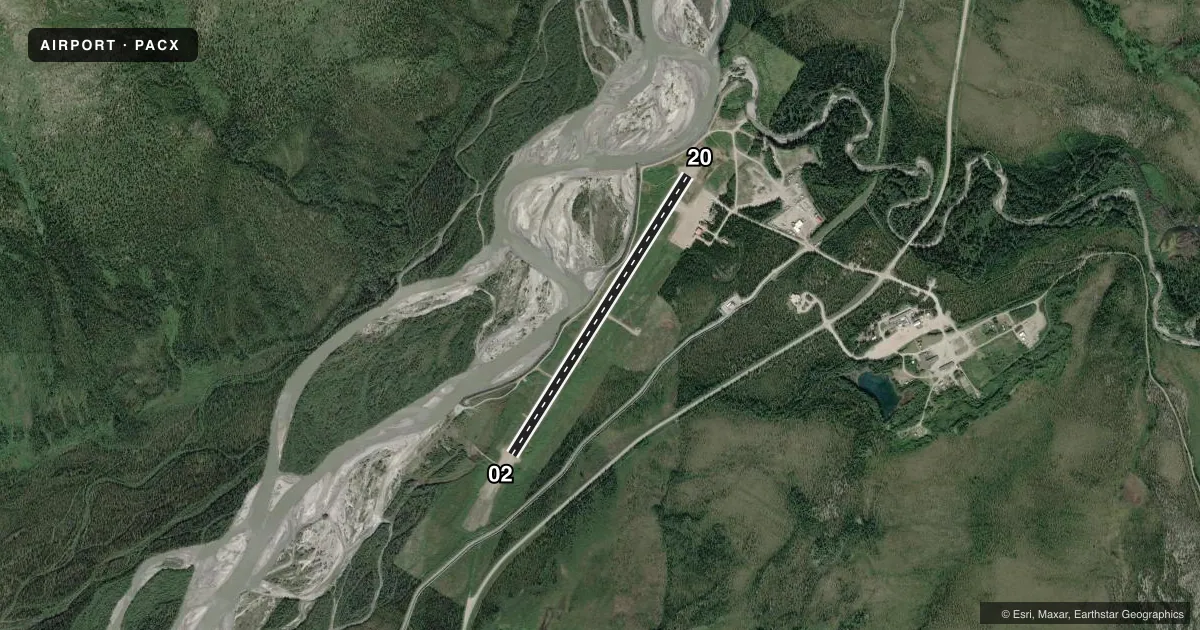
Runways & pattern
Full pagePattern entry · RWY 02
LEFT TRAFFICRunway end performance
| End | TORA | TODA | ASDA | LDA | VGSI | Approach lights | Obstruction |
|---|---|---|---|---|---|---|---|
| 02 | — | — | — | — | — | — | 4', brush, 0' from thr, 155' R of cntrln, slope 0 |
| 20 | — | — | — | — | — | — | 67', trees, 865' from thr, 65' R of cntrln, slope 12 |
Declared distances in feet. TORA = takeoff run available, TODA = takeoff distance, ASDA = accelerate-stop, LDA = landing distance.
Airport sketch
Runways drawn to scale from FAA survey coordinates, rendered over satellite imagery. Not for navigation.
Approaches & charts
Services on the field
Fuel grades, oxygen, maintenance, ramp storage and lighting — as declared to the FAA by the airport operator.
Fuel & services
- Fuel
- Not available
- Oxygen (bottled)
- Not available
- Oxygen (bulk)
- Not available
- Airframe repair
- Not available
- Power plant repair
- Not available
Ramp & ground
- Transient storage
- Tie-down
- Landing fee
- No fee published
- Customs
- Not available
- Lighting schedule
- SEE RMK
- Beacon schedule
- SS-SR
- Beacon
- White / Green (civil land)(WG)
- Wind indicator
- Yes
- Segmented circle
- Yes
Fuel & FBOs
Cheapest 100LL and Jet A on the field and nearby. Always confirm with the FBO before taxi.
Airport notes
Surface conditions, obstructions, local procedures, lighting outages and other notes published with each FAA cycle.
General notes
- RY COND NOT MONITORED; RECOMMEND VISUAL INSPECTION PRIOR TO USING.
- WX CAMERA AVBL ON INTERNET AT HTTPS://WEATHERCAMS.FAA.GOV
- COLD TEMPERATURE AIRPORT. ALTITUDE CORRECTION REQUIRED AT OR BELOW -18C.
Lighting notes
- ACTVT MIRL RY 02/20 & TWY LGTS - CTAF.
VFR map & nearby airports
VFR sectional. Tap any ICAO chip to open that airport.
Key facts · PACX
Answer card- ICAO
- PACX
- Name
- COLDFOOT
- Location
- COLDFOOT, ALASKA
- Elevation
- 1,049.1 ft MSL
- Traffic pattern altitude
- 2,049.1 ft MSL (1,000 AGL)
- Control tower
- Non-towered (use CTAF)
- Total runways
- 1
- Longest runway
- 02/20 · 4,011 ft
- Published ILS approaches
- 0
- Published frequencies
- 1
- Magnetic variation
- 16°
- Current flight rules
- VFR
- Current wind
- 030° at 7 kt
- Favored runway now
- RWY 02
Coldfoot Airport sits in Coldfoot, Alaska. Field elevation is 1,049.1 ft MSL. The airport has one runway. Runway 02/20 is 4,011 ft long and gravel. There is no control tower. CTAF is 122.9. No ILS approaches are published here.
Pattern altitude is not published. Use 1,000 ft AGL as the standard light piston pattern unless local procedures or current guidance say otherwise. That puts the normal pattern near 2,049 ft MSL based on the listed field elevation. This is a cold temperature airport. Altitude correction is required at or below minus 18 degrees Celsius. Runway condition is not monitored, so a visual inspection before use is a good idea. The runway lights and taxiway lights on 02/20 are activated by CTAF. A weather camera is available online for a quick look before departure.
There are no on-field FBOs listed in the facts. Plan on checking with the airport operator or the FBO directly by phone before arrival if you need current services. For a first trip, pay attention to the gravel surface, the cold weather correction note and the lack of published ILS support. In this part of Alaska, weather and surface condition matter as much as runway length.