METAR & TAF PFYU
Current METAR
Observed 22:56Z
PFYU 272256Z VRB05KT 10SM SCT110 24/14 A2972
- Wind
- VAR @ 5 kt
- Visibility
- 10 SM
- Temp / Dew
- 24°C / 14°C
- Altimeter
- 29.72 inHg
- Clouds
- SCT
- Density alt
- 1,883 ft
- Ceiling
- Unlimited
- Rules
- VFR
Airport info & contacts
Manager on record, flight service, ARTCC, attendance schedule and pattern altitude — published by the FAA and refreshed every 28 days.
Location
- From city
- 0 NM N
- VFR sectional
- FAIRBANKS
- ARTCC
- ZAN · ANCHORAGE
- NOTAM facility
- FYU (NOTAM-D)
Airport manager
- Name
- JASON LUDINGTON
- Phone
- 907-451-5280
- Address
- 2301 PEGER RD, FAIRBANKS AK 99709
Flight service · Hours
- FSS FAI
- FAIRBANKS907-474-07881-866-248-6516
- Attendance
- Unattended
Frequencies
Tap any row to copy the frequency to your clipboard.
Runways & pattern
Full pagePattern entry · RWY 04
LEFT TRAFFICRunway end performance
| End | TORA | TODA | ASDA | LDA | VGSI | Approach lights | Obstruction |
|---|---|---|---|---|---|---|---|
| 04 | — | — | — | — | VASI 4-box left(3°) | — | 4', brush, 0' from thr, 174' R of cntrln, slope 0 |
| 22 | — | — | — | — | VASI 4-box left(3°) | MALSF | 2', brush, 0' from thr, 225' R of cntrln, slope 0 |
Declared distances in feet. TORA = takeoff run available, TODA = takeoff distance, ASDA = accelerate-stop, LDA = landing distance.
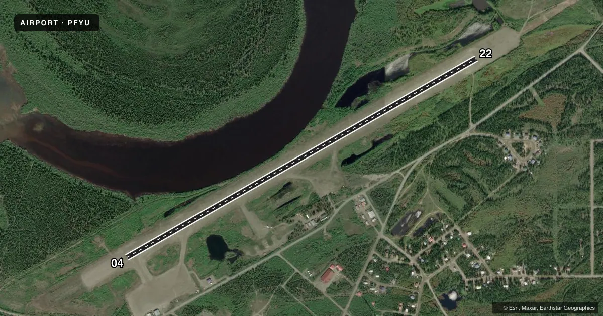
Airport sketch
Runways drawn to scale from FAA survey coordinates, rendered over satellite imagery. Not for navigation.
Approaches & charts
Services on the field
Fuel grades, oxygen, maintenance, ramp storage and lighting — as declared to the FAA by the airport operator.
Fuel & services
- Fuel
- Not available
Ramp & ground
- Transient storage
- Not published
- Landing fee
- No fee published
- Customs
- Not available
- Lighting schedule
- SEE RMK
- Beacon schedule
- SS-SR
- Beacon
- White / Green (civil land)(WG)
- Wind indicator
- Lighted
- Segmented circle
- Yes
Fuel & FBOs
Cheapest 100LL and Jet A on the field and nearby. Always confirm with the FBO before taxi.
Airport notes
Surface conditions, obstructions, local procedures, lighting outages and other notes published with each FAA cycle.
General notes
- FLOAT PLANE OPS DO NOT CROSS RWY 04/22. TFC PAT FOR HOSPITAL LAKE RMN NW OF ARPT.
- LINE OF SIGHT BTN RWY THRS & WATERLANE NA; MON CTAF SPCLY BFR DEP.
- SNOW REMOVAL OPS MNT CTAF.
- RWY COND UNMNT; RCMD VISUAL INSP BFR LNDG.
- SUAIS - 125.3/126.3/1-800-758-8723.
- WX OBS CALLSIGN FORT YUKON WX - CTAF OR 907-662-2948 FM 0700-1900.
- BIRDS INVOF LANDFILL 1/4 MI NW OF RWY.
- WX CAMERA AVBL ON INTERNET AT HTTPS://WEATHERCAMS.FAA.GOV
- TWY C REFLECTORS 36 IN; UNLGT; CLSD DURG WINTER.
Lighting notes
- ACTVT MALSF RWY 22; VASI RWY 04 & 22; MIRL RWY 04/22 - CTAF.
Approach & departure obstructions
- 04DEP COMMENCE AT DTHR.
VFR map & nearby airports
VFR sectional. Tap any ICAO chip to open that airport.
Key facts · PFYU
Answer card- ICAO
- PFYU
- Name
- FORT YUKON
- Location
- FORT YUKON, ALASKA
- Elevation
- 447.2 ft MSL
- Traffic pattern altitude
- 1,447.2 ft MSL (1,000 AGL)
- Control tower
- Non-towered (use CTAF)
- Total runways
- 1
- Longest runway
- 04/22 · 5,000 ft
- Published ILS approaches
- 0
- Published frequencies
- 1
- Magnetic variation
- 20°
- Current flight rules
- VFR
- Current wind
- 000° at 5 kt
- Favored runway now
- RWY 04
Fort Yukon Airport (PFYU) sits in Fort Yukon, Alaska. Field elevation is 447.2 ft MSL. The airport has one runway. Runway 04/22 is 5,000 ft long with a gravel-dirt surface. There is no control tower. CTAF is 122.5.
No ILS approaches are published here. Pattern altitude is not published, so use the standard 1,000 ft AGL for light piston operations unless the current FAA Chart Supplement says otherwise. Runway lighting is on CTAF control. Runway 22 has MALSR. VASI is available on both runway ends. The published remarks also say runway condition is unmonitored, so a visual check before landing is smart. Snow removal crews monitor CTAF. Line of sight between the runway thresholds and the waterlane is not available, so keep a close ear on CTAF before departure.
There are no on-field FBOs listed. Jet A is available from May through September. Call 907-662-2408 for current fuel availability. The airport also has weather observations on CTAF or by phone at 907-662-2948 from 0700 to 1900. First-time pilots should also watch for birds near the landfill northwest of the runway. Special use airspace information is available by phone if you need it before launch.