METAR & TAF PACR
PACR does not publish a METAR.
Showing the nearest reporting station: PFYU (FORT YUKON) · 52.9 NM away. Conditions at PACR may differ.
METAR · PFYU
Observed 21:56Z
PFYU 272156Z 02005KT 10SM CLR 23/14 A2973
- Wind
- 020° @ 5 kt
- Visibility
- 10 SM
- Temp / Dew
- 23°C / 14°C
- Altimeter
- 29.73 inHg
- Clouds
- CLR
- Density alt
- 1,956 ft
- Ceiling
- Unlimited
- Rules
- VFR
Airport info & contacts
Manager on record, flight service, ARTCC, attendance schedule and pattern altitude — published by the FAA and refreshed every 28 days.
Location
- From city
- 0 NM W
- VFR sectional
- DAWSON
- ARTCC
- ZAN · ANCHORAGE
- NOTAM facility
- FAI (NOTAM-D)
Airport manager
- Name
- JASON LUDINGTON
- Phone
- (907) 451-5280
- Address
- 2301 PEGER ROAD, FAIRBANKS AK 99709-6394
Flight service · Hours
- FSS FAI
- FAIRBANKS907-474-07881-866-248-6516
- Attendance
- Unattended
Frequencies
Tap any row to copy the frequency to your clipboard.
Runways & pattern
Full pagePattern entry · RWY 33
LEFT TRAFFICRunway end performance
| End | TORA | TODA | ASDA | LDA | VGSI | Approach lights | Obstruction |
|---|---|---|---|---|---|---|---|
| 15 | — | — | — | — | — | — | 6', brush, 0' from thr, 75' R of cntrln, slope 0 |
| 33 | — | — | — | — | — | — | 6', brush, 0' from thr, 75' R of cntrln, slope 0 |
Declared distances in feet. TORA = takeoff run available, TODA = takeoff distance, ASDA = accelerate-stop, LDA = landing distance.
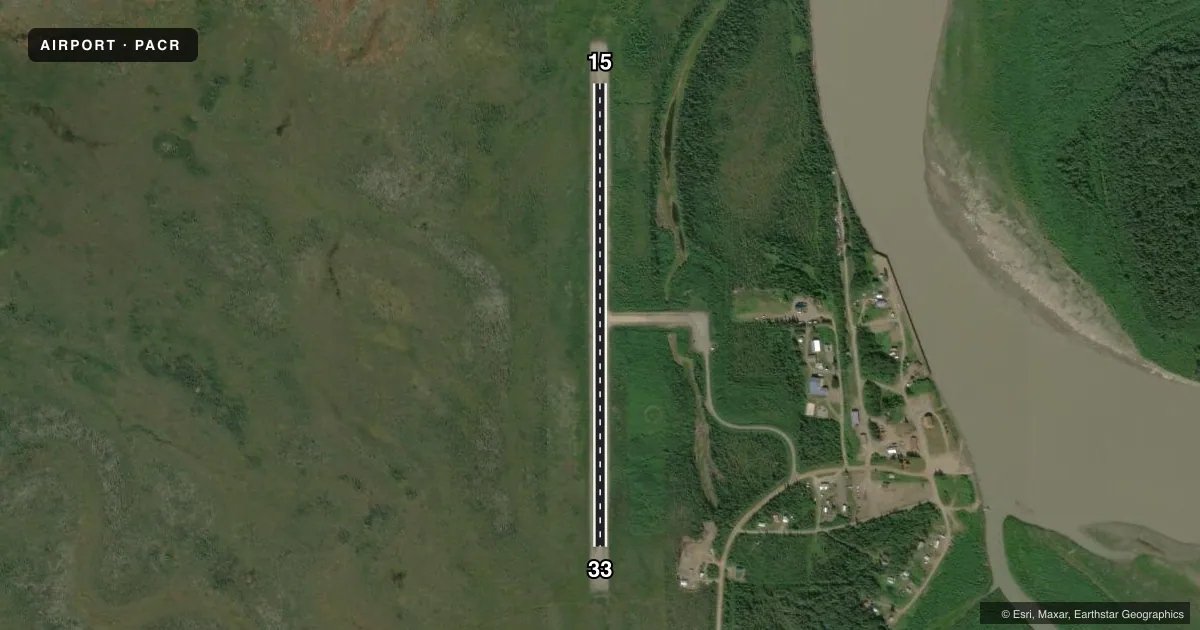
Airport sketch
Runways drawn to scale from FAA survey coordinates, rendered over satellite imagery. Not for navigation.
Approaches & charts
Services on the field
Fuel grades, oxygen, maintenance, ramp storage and lighting — as declared to the FAA by the airport operator.
Fuel & services
- Fuel
- 100LL
Ramp & ground
- Transient storage
- Not published
- Lighting schedule
- SEE RMK
- Beacon schedule
- SEE RMK
- Beacon
- White / Green (civil land)(WG)
- Wind indicator
- Lighted
- Segmented circle
- Yes
Fuel & FBOs
Cheapest 100LL and Jet A on the field and nearby. Always confirm with the FBO before taxi.
Airport notes
Surface conditions, obstructions, local procedures, lighting outages and other notes published with each FAA cycle.
General notes
- RY COND NOT MONITORED OR MAINTAINED; RECOMMEND VISUAL INSPECTION PRIOR TO LANDING.
- SUAIS - 125.3/126.3(1-800-758-8723).
- SNOW REMOVAL OPERATIONS DURING WINTER--MONITOR CTAF.
- SEGMENTED CIRCLE OVERGROWN.
Lighting notes
- SS-SR. ACTVT BEACON - CTAF.
- ACTVT MIRL RY 15/33 - CTAF.
Fuel notes
- 100LL100LL AVBL OFF ARPT AT STORE IN TOWN. TAXI VIA ARPT ACCESS ROAD.
Approach & departure obstructions
- 15RY 15/33 THLDS MKD WITH REFLECTIVE PANELS.
Other notes
- THIS AIRPORT HAS BEEN SURVEYED BY THE NATIONAL GEODETIC SURVEY.
- FILED FOR RECORD PURPOSES ONLY.
- SEGMENTED CIRCLE OVERGROWN. WINDSOCK MAY BE UNRELIABLE.
VFR map & nearby airports
VFR sectional. Tap any ICAO chip to open that airport.
Key facts · PACR
Answer card- ICAO
- PACR
- Name
- CIRCLE CITY
- Location
- CIRCLE, ALASKA
- Elevation
- 613.2 ft MSL
- Traffic pattern altitude
- 1,613.2 ft MSL (1,000 AGL)
- Control tower
- Non-towered (use CTAF)
- Total runways
- 1
- Longest runway
- 15/33 · 2,979 ft
- Published ILS approaches
- 0
- Published frequencies
- 1
- Magnetic variation
- 30°
- Current flight rules
- VFR
- Current wind
- 020° at 5 kt
- Favored runway now
- RWY 33
Circle City Airport (PACR) sits in Circle, Alaska. Field elevation is 613.2 ft MSL. The airport has one runway. Runway 15/33 is 2,979 ft long with a gravel-dirt surface. No tower is published here. CTAF is 122.9.
No ILS approaches are published. Pattern altitude is not published, so use the standard 1,000 ft AGL for light piston operations unless the current Chart Supplement says otherwise. The runway lights on 15/33 are activated by the CTAF. The beacon is also CTAF-activated and runs from sunset to sunrise.
This is a field where a careful preflight matters. The segmented circle is overgrown. The windsock may be unreliable. Runway condition is not monitored or maintained. Do a visual inspection before you land. Snow removal happens in winter. Monitor the CTAF for traffic and field updates. Runway thresholds are marked with reflective panels.
There is no on-field FBO listed. 100LL is available off airport at the store in town. Taxi via the airport access road. Special use airspace information is available on 125.3 or 126.3. You can also call 1-800-758-8723. This airport has been surveyed by the National Geodetic Survey.