METAR & TAF D66
D66 does not publish a METAR.
Showing the nearest reporting station: PAFA (FAIRBANKS INTL) · 71.9 NM away. Conditions at D66 may differ.
METAR · PAFA
Observed 22:53Z
PAFA 252253Z 00000KT 10SM SCT043 BKN200 19/11 A2977
- Wind
- 000° @ 0 kt
- Visibility
- 10 SM
- Temp / Dew
- 19°C / 11°C
- Altimeter
- 29.77 inHg
- Clouds
- BKN
- Density alt
- 2,092 ft
- Ceiling
- 20,000 ft AGL
- Rules
- VFR
Airport info & contacts
Manager on record, flight service, ARTCC, attendance schedule and pattern altitude — published by the FAA and refreshed every 28 days.
Location
- From city
- 1 NM N
- VFR sectional
- FAIRBANKS
- ARTCC
- ZAN · ANCHORAGE
- NOTAM facility
- FAI (NOTAM-D)
Airport manager
- Name
- ALAN LEVINSON
- Phone
- 907-460-0066
- Address
- CITY OF DELTA JUNCTION, PO BOX 229, DELTA JUNCTION AK 99737
Flight service · Hours
- FSS FAI
- FAIRBANKS907-474-07881-866-248-6516
- Attendance
- Unattended
Frequencies
Tap any row to copy the frequency to your clipboard.
Runways & pattern
Full pagePattern entry · RWY 07
LEFT TRAFFICRunway end performance
| End | TORA | TODA | ASDA | LDA | VGSI | Approach lights | Obstruction |
|---|---|---|---|---|---|---|---|
| 07 | — | — | — | — | — | — | 55', trees, 265' from thr, 180' R of cntrln, slope 4 |
| 25 | — | — | — | — | — | — | 30', trees, 315' from thr, 115' R of cntrln, slope 10 |
Declared distances in feet. TORA = takeoff run available, TODA = takeoff distance, ASDA = accelerate-stop, LDA = landing distance.
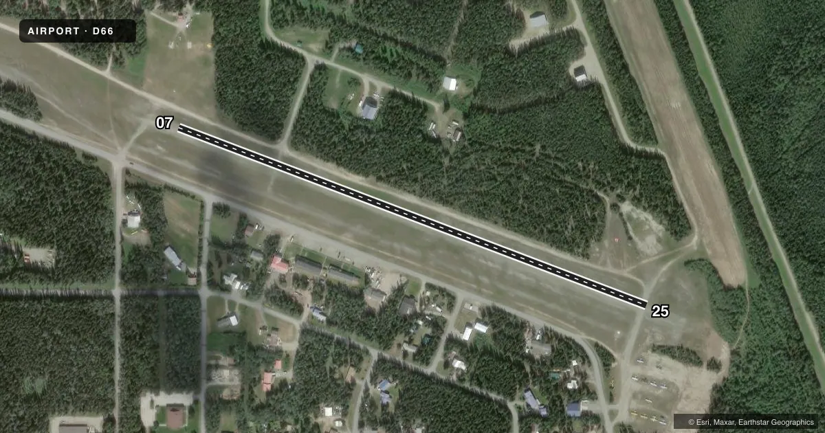
Airport sketch
Runways drawn to scale from FAA survey coordinates, rendered over satellite imagery. Not for navigation.
Approaches & charts
Services on the field
Fuel grades, oxygen, maintenance, ramp storage and lighting — as declared to the FAA by the airport operator.
Fuel & services
- Fuel
- Not available
- Other services
- INSTR
Ramp & ground
- Transient storage
- Tie-down
- Wind indicator
- Yes
- Segmented circle
- No
Fuel & FBOs
Cheapest 100LL and Jet A on the field and nearby. Always confirm with the FBO before taxi.
Airport notes
Surface conditions, obstructions, local procedures, lighting outages and other notes published with each FAA cycle.
General notes
- RWY COND UNMNT; RCMND VISUAL INSP BFR USE.
- SUAIS - 125.3/126.3; 1-800-758-8723.
- WX CAMERA AVBL ON INTERNET AT HTTPS://WEATHERCAMS.FAA.GOV
- ALLEN AAF WI 5 MI.
- USE FEE - AMGR.
- TSNT PRKG E END; S OF RWY 07.
- PAEW ON RWY.
- 335 FT TWR LGTD 1 MI S.
Approach & departure obstructions
- 07REFLECTIVE CONES.
- 25REFLECTIVE CONES.
- 07PWR LINE MKD WITH ORANGE BALLS W. CLNC SLOPE 33:1 TO PWR LINE.
- 25WINDSOCK
Other notes
- AIRSPACE DETERMINATION PENDING.
VFR map & nearby airports
VFR sectional. Tap any ICAO chip to open that airport.
Key facts · D66
Answer card- ICAO
- D66
- Name
- DELTA JUNCTION
- Location
- DELTA JUNCTION, ALASKA
- Elevation
- 1,150 ft MSL
- Traffic pattern altitude
- 2,150 ft MSL (1,000 AGL)
- Control tower
- Non-towered (use CTAF)
- Total runways
- 1
- Longest runway
- 07/25 · 2,500 ft
- Published ILS approaches
- 0
- Published frequencies
- 1
- Magnetic variation
- 28°
- Current flight rules
- VFR
- Current wind
- 000° at 0 kt
- Favored runway now
- –
Delta Junction Airport (D66) sits in Delta Junction, Alaska at 1,150 ft MSL. It has one runway. The longest is 07/25 at 2,500 ft. The field is non-towered, so CTAF 122.9 is the main traffic frequency. No ILS approaches are published here. Pattern altitude is not published, so use the standard 1,000 ft AGL for light piston aircraft unless the current Chart Supplement says otherwise.
The published remarks call out a few things worth planning for. There is a power line west of runway 07 with orange balls on it. Reflective cones mark both runway ends. A windsock is at the runway 25 end. Transient parking is available at the east end south of runway 07. Allen Army Airfield is within 5 miles, so expect nearby military traffic in the area. Airspace determination is still pending in the published remarks, so check the current sectional or Chart Supplement before you go.
No on-field FBOs are listed. Contact the airport operator directly before arrival if you need services. The Chart Supplement also notes a use fee. A 335-foot lighted tower sits 1 mile south. Weather camera access is available through the FAA weather camera system.