METAR & TAF PAAO
PAAO does not publish a METAR.
Showing the nearest reporting station: PAGK (GULKANA) · 32.5 NM away. Conditions at PAAO may differ.
METAR · PAGK
Observed 14:53Z
PAGK 271453Z AUTO 18004KT 10SM CLR 09/08 A2985 RMK AO2 SLP109 T00940083 53005 TSNO
- Wind
- 180° @ 4 kt
- Visibility
- 10 SM
- Temp / Dew
- 9°C / 8°C
- Altimeter
- 29.85 inHg
- Clouds
- CLR
- Density alt
- 2,442 ft
- Ceiling
- Unlimited
- Rules
- VFR
Airport info & contacts
Manager on record, flight service, ARTCC, attendance schedule and pattern altitude — published by the FAA and refreshed every 28 days.
Location
- From city
- 1 NM NE
- VFR sectional
- ANCHORAGE
- ARTCC
- ZAN · ANCHORAGE
- NOTAM facility
- ENA (NOTAM-D)
Airport manager
- Name
- CHAD HELLER
- Phone
- 907-822-3222
- Address
- PO BOX 7, GLENNALLEN AK 99588
Flight service · Hours
- FSS ENA
- KENAI907-283-72111-866-864-1737
- Attendance
- Unattended
Frequencies
Tap any row to copy the frequency to your clipboard.
Runways & pattern
Full pagePattern entry · RWY 13
RIGHT TRAFFICRunway end performance
| End | TORA | TODA | ASDA | LDA | VGSI | Approach lights | Obstruction |
|---|---|---|---|---|---|---|---|
| 13 | — | — | — | — | — | — | 12', brush, 0' from thr, 85' R of cntrln, slope 0 |
| 31 | — | — | — | — | — | — | 32', trees, 1049' from thr, slope 32 |
Declared distances in feet. TORA = takeoff run available, TODA = takeoff distance, ASDA = accelerate-stop, LDA = landing distance.
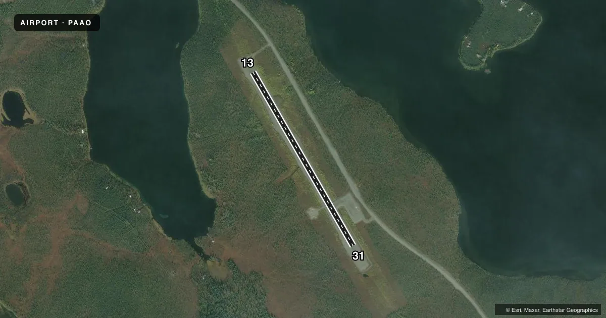
Airport sketch
Runways drawn to scale from FAA survey coordinates, rendered over satellite imagery. Not for navigation.
Approaches & charts
Services on the field
Fuel grades, oxygen, maintenance, ramp storage and lighting — as declared to the FAA by the airport operator.
Fuel & services
- Fuel
- Not available
Ramp & ground
- Transient storage
- Tie-down
- Landing fee
- No fee published
- Customs
- Not available
- Wind indicator
- Yes
- Segmented circle
- Yes
Fuel & FBOs
Cheapest 100LL and Jet A on the field and nearby. Always confirm with the FBO before taxi.
Airport notes
Surface conditions, obstructions, local procedures, lighting outages and other notes published with each FAA cycle.
General notes
- RWY COND UNMNT; RCMD VISUAL INSP BFR LNDG.
- RADIO UNAVBL TO CLOSE FP.
- WINTER MAINT NA.
- CTN: LAKE FLOAT PLANE ACT.
- CARIBOU INVOF RWY.
Approach & departure obstructions
- 13RED & GREEN THR REFLECTORS; REFLECTIVE WHITE MKRS FULL LEN; REFLECTIVE BLUE MARKERS ON TWY.
- 31RED & GREEN THR REFLECTORS; REFLECTIVE WHITE MKRS FULL LEN; REFLECTIVE BLUE MARKERS ON TWY.
VFR map & nearby airports
VFR sectional. Tap any ICAO chip to open that airport.
Key facts · PAAO
Answer card- ICAO
- PAAO
- Name
- LAKE LOUISE
- Location
- LAKE LOUISE, ALASKA
- Elevation
- 2,480.2 ft MSL
- Traffic pattern altitude
- 3,480.2 ft MSL (1,000 AGL)
- Control tower
- Non-towered (use CTAF)
- Total runways
- 1
- Longest runway
- 13/31 · 2,900 ft
- Published ILS approaches
- 0
- Published frequencies
- 1
- Magnetic variation
- 27°
- Current flight rules
- VFR
- Current wind
- 180° at 4 kt
- Favored runway now
- RWY 13
Lake Louise Airport (PAAO) sits in Lake Louise, Alaska. Field elevation is 2,480.2 ft MSL. The airport has one runway. Runway 13/31 is 2,900 ft long and gravel. The field is not towered, so use CTAF 122.9 for self-announce traffic. No ILS approaches are published here.
Pattern altitude is not published. Use the standard 1,000 ft AGL pattern for light piston aircraft unless the current Chart Supplement or local traffic calls for something different. With a field elevation of 2,480.2 ft MSL, that puts the usual light-aircraft pattern near 3,480.2 ft MSL. Verify the current pattern and traffic flow before arrival.
There are no on-field FBOs listed. Check with the airport operator or the FBO directly by phone if you need current services. Published remarks call out reflective threshold markers on both ends of the runway, with white edge markers along the length and blue markers on the taxiway. Runway condition is unmonitored, so a visual inspection before landing is smart. Expect lake float plane activity. Caribou are also reported near the runway. Winter maintenance is not available, so plan for seasonal surface and access limits.