METAR & TAF 5AK
5AK does not publish a METAR.
Showing the nearest reporting station: PAGK (GULKANA) · 28.5 NM away. Conditions at 5AK may differ.
METAR · PAGK
Observed 05:38Z
PAGK 270538Z AUTO 16004KT 10SM OVC031 15/12 A2980 RMK AO2 T01500117 TSNO
- Wind
- 160° @ 4 kt
- Visibility
- 10 SM
- Temp / Dew
- 15°C / 12°C
- Altimeter
- 29.80 inHg
- Clouds
- OVC
- Density alt
- 3,144 ft
- Ceiling
- 3,100 ft AGL
- Rules
- VFR
Airport info & contacts
Manager on record, flight service, ARTCC, attendance schedule and pattern altitude — published by the FAA and refreshed every 28 days.
Location
- From city
- 0 NM E
- VFR sectional
- ANCHORAGE
- ARTCC
- ZAN · ANCHORAGE
- NOTAM facility
- ENA (NOTAM-D)
Airport manager
- Name
- BONNY WIKLE
- Phone
- 907-822-3061
- Address
- MILE 156 GLENN HWY, HC1 BOX 2640, GLENNALLEN AK 99588
Flight service · Hours
- FSS ENA
- KENAI907-283-72111-866-864-1737
- Attendance
- DALGT
Frequencies
Tap any row to copy the frequency to your clipboard.
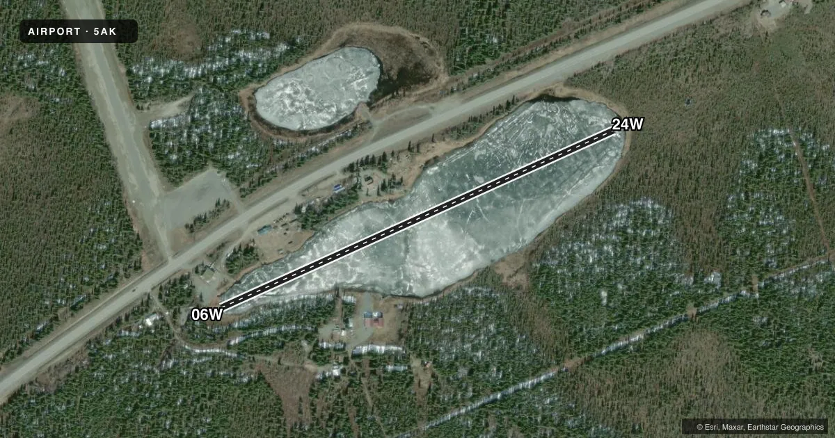
Runways & pattern
Full pagePattern entry · RWY 24W
LEFT TRAFFICAirport sketch
Runways drawn to scale from FAA survey coordinates, rendered over satellite imagery. Not for navigation.
Approaches & charts
Services on the field
Fuel grades, oxygen, maintenance, ramp storage and lighting — as declared to the FAA by the airport operator.
Fuel & services
- Fuel
- Not available
Ramp & ground
- Transient storage
- Not published
- Landing fee
- No fee published
- Customs
- Not available
- Segmented circle
- No
Fuel & FBOs
Cheapest 100LL and Jet A on the field and nearby. Always confirm with the FBO before taxi.
Airport notes
Surface conditions, obstructions, local procedures, lighting outages and other notes published with each FAA cycle.
General notes
- LODGE CLSD; DOCKS NA; PVT RAMP & HANGAR SW OF LODGE.
VFR map & nearby airports
VFR sectional. Tap any ICAO chip to open that airport.
Key facts · 5AK
Answer card- ICAO
- 5AK
- Name
- TAZLINA/SMOKEY LAKE
- Location
- TAZLINA, ALASKA
- Elevation
- 2,415.4 ft MSL
- Traffic pattern altitude
- 3,415.4 ft MSL (1,000 AGL)
- Control tower
- Non-towered (use CTAF)
- Total runways
- 1
- Longest runway
- 06W/24W · 2,280 ft
- Published ILS approaches
- 0
- Published frequencies
- 1
- Magnetic variation
- 27°
- Current flight rules
- VFR
- Current wind
- 160° at 4 kt
- Favored runway now
- RWY 24W
Tazlina/Smokey Lake (5AK) sits in Tazlina, Alaska. Field elevation is 2,415.4 ft MSL. The airport has one runway. It is a 2,280 ft water runway, 06W/24W. This is a non-towered field. CTAF is 122.9.
No ILS approaches are published here. Pattern altitude is not published. Use the standard 1,000 ft AGL unless the current Chart Supplement or local procedures say otherwise. That puts the pattern at about 3,415.4 ft MSL based on field elevation. The magnetic variation listed for the field is 27°.
There are no on-field FBOs listed. Plan on self-sufficiency. The published remarks say the lodge is closed. Docks are not available. There is a private ramp and hangar southwest of the lodge. That matters for arrival planning on the water. Verify current access and tie-down options with the airport operator before you go. In this part of Alaska, the higher field elevation also means performance planning matters. Check density altitude, weight and takeoff distance before committing.