METAR & TAF PASP
PASP does not publish a METAR.
Showing the nearest reporting station: PAAQ (WARREN "BUD" WOODS PALMER MUNI) · 46.8 NM away. Conditions at PASP may differ.
METAR · PAAQ
Observed 19:53Z
PAAQ 271953Z 13004KT 10SM FEW003 OVC025 12/11 A2987 RMK AO2 SLP117 T01220106 $
- Wind
- 130° @ 4 kt
- Visibility
- 10 SM
- Temp / Dew
- 12°C / 11°C
- Altimeter
- 29.87 inHg
- Clouds
- OVC
- Density alt
- 3,112 ft
- Ceiling
- 2,500 ft AGL
- Rules
- MVFR
Airport info & contacts
Manager on record, flight service, ARTCC, attendance schedule and pattern altitude — published by the FAA and refreshed every 28 days.
Location
- From city
- 0 NM W
- VFR sectional
- ANCHORAGE
- ARTCC
- ZAN · ANCHORAGE
- NOTAM facility
- ENA (NOTAM-D)
Airport manager
- Name
- ANDY WEILAND
- Phone
- 745-5116
- Address
- 289 INNER SPRINGER LOOP RD., PALMER AK 99645
Flight service · Hours
- FSS ENA
- KENAI907-283-72111-866-864-1737
- Attendance
- Unattended
Frequencies
Tap any row to copy the frequency to your clipboard.
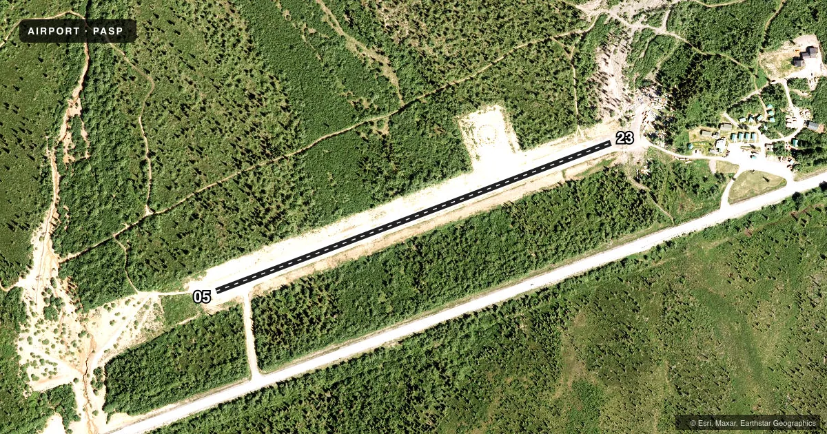
Runways & pattern
Full pagePattern entry · RWY 05
LEFT TRAFFICRunway end performance
| End | TORA | TODA | ASDA | LDA | VGSI | Approach lights | Obstruction |
|---|---|---|---|---|---|---|---|
| 05 | — | — | — | — | — | — | 29', trees, 0' from thr, 121' R of cntrln, slope 0 |
| 23 | — | — | — | — | — | — | 15', road, 0' from thr, 59' R of cntrln, slope 0 |
Declared distances in feet. TORA = takeoff run available, TODA = takeoff distance, ASDA = accelerate-stop, LDA = landing distance.
Airport sketch
Runways drawn to scale from FAA survey coordinates, rendered over satellite imagery. Not for navigation.
Approaches & charts
Services on the field
Fuel grades, oxygen, maintenance, ramp storage and lighting — as declared to the FAA by the airport operator.
Fuel & services
- Fuel
- Not available
Ramp & ground
- Transient storage
- Not published
- Landing fee
- No fee published
- Customs
- Not available
- Wind indicator
- Yes
- Segmented circle
- No
Fuel & FBOs
Cheapest 100LL and Jet A on the field and nearby. Always confirm with the FBO before taxi.
Airport notes
Surface conditions, obstructions, local procedures, lighting outages and other notes published with each FAA cycle.
General notes
- RWY COND UNMNT; RCMD VISUAL INSP BFR USE.
- TAHNETA PASS WX CAMERA AVBL ON INTERNET AT HTTPS://WEATHERCAMS.FAA.GOV
Runway surface & condition
- 05/23EMERG USE ONLY. EXP TURB WINDS. VEHICLES ON RWY. MAINT NA. CROSSWISE SLOPE N TO S UP TO 9%. VEHICLE TRAIL ALG BOTH SIDES.
Approach & departure obstructions
- 231% UPSLOPE.
Other notes
- UNRELIABLE.
- 05/233 FT WEEDS & BRUSH.
- 05/23LRG LOOSE ROCK.
VFR map & nearby airports
VFR sectional. Tap any ICAO chip to open that airport.
Key facts · PASP
Answer card- ICAO
- PASP
- Name
- SHEEP MOUNTAIN
- Location
- SHEEP MOUNTAIN, ALASKA
- Elevation
- 2,750 ft MSL
- Traffic pattern altitude
- 3,750 ft MSL (1,000 AGL)
- Control tower
- Non-towered (use CTAF)
- Total runways
- 1
- Longest runway
- 05/23 · 2,270 ft
- Published ILS approaches
- 0
- Published frequencies
- 1
- Magnetic variation
- 26°
- Current flight rules
- MVFR
- Current wind
- 130° at 4 kt
- Favored runway now
- RWY 05
Sheep Mountain Airport sits at Sheep Mountain in Alaska. Field elevation is 2,750 ft MSL. The airport has one runway, 05/23, which is 2,270 ft long. There is no control tower. CTAF is 122.9. No ILS approaches are published.
Pattern altitude is not published. Use standard 1,000 ft AGL unless the current FAA Chart Supplement says otherwise. That puts the normal pattern reference at 3,750 ft MSL. The runway heading is 05/23 with magnetic headings of 69° and 249°. The runway surface is gravel-dirt. Published remarks say the strip is for emergency use only. Expect turbulent winds. Vehicles may be on the runway. Maintenance is not available. The runway condition is unmonitored, so a visual inspection before use is a smart move.
There are no on-field FBOs listed. Plan on self-sufficiency. The published remarks also note 3 ft of weeds and brush on the runway. Runway 23 has a 1 percent upslope. The crosswise slope from north to south can be as much as 9 percent. The wind indicator is unreliable. This is a short, rough mountain strip with limited support. Check the current FAA Chart Supplement and the airport operator before you go. The weather camera at Tahneta Pass is available online for a current look at conditions.