METAR & TAF PAAQ
Current METAR
Observed 18:10Z
PAAQ 271810Z VRB03KT 9SM -RA BKN029 OVC037 12/11 A2985 RMK AO2 P0001 T01170106 $
- Wind
- VAR @ 3 kt
- Visibility
- 9 SM
- Temp / Dew
- 12°C / 11°C
- Altimeter
- 29.85 inHg
- Clouds
- OVC
- Density alt
- 35 ft
- Ceiling
- 2,900 ft AGL
- Rules
- MVFR
Airport info & contacts
Manager on record, flight service, ARTCC, attendance schedule and pattern altitude — published by the FAA and refreshed every 28 days.
Location
- From city
- 1 NM SE
- VFR sectional
- ANCHORAGE
- ARTCC
- ZAN · ANCHORAGE
- NOTAM facility
- PAQ (NOTAM-D)
Airport manager
- Name
- JOHN DIUMENTI
- Phone
- 907-761-1334
- Address
- 231 W EVERGREEN, PALMER AK 99645
Flight service · Hours
- FSS PAQ
- PALMER907-745-2495LC745-2495
- Attendance
- M-F · 0800-1700
Frequencies
Tap any row to copy the frequency to your clipboard.
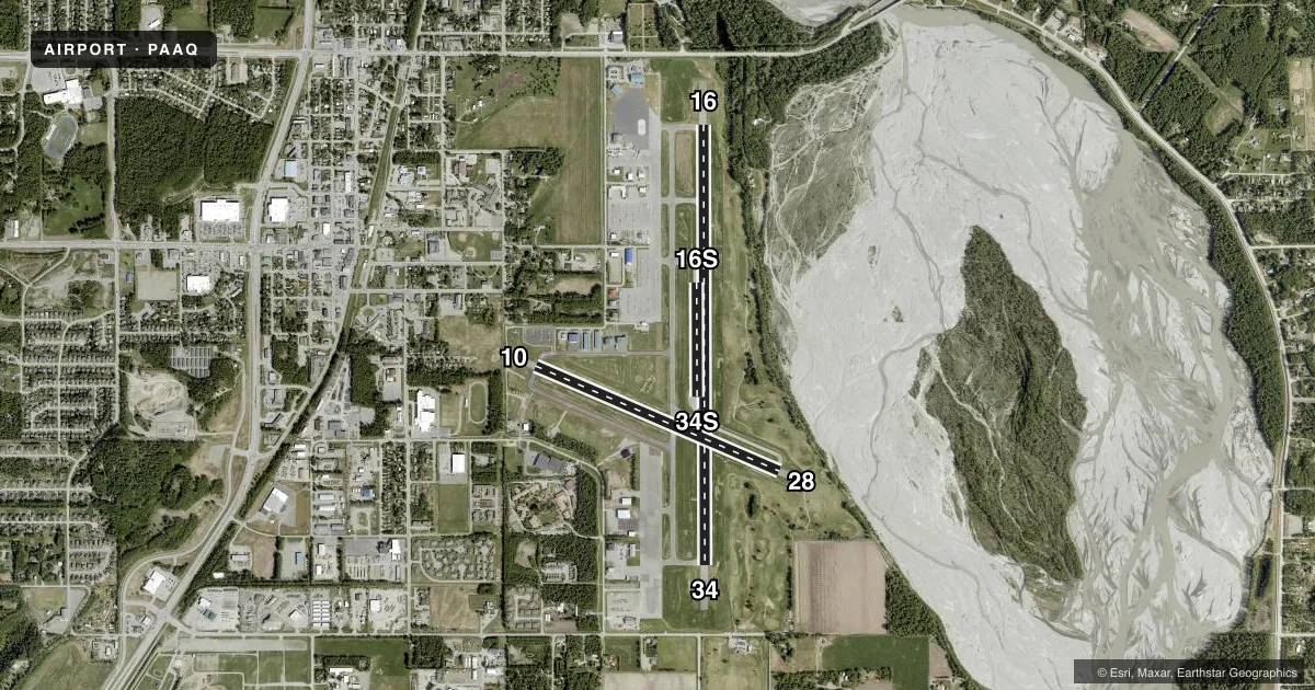
Runways & pattern
Full pagePattern entry · RWY 34
LEFT TRAFFIC| Runway | Heading (°M) | Length | Surface | Traffic |
|---|---|---|---|---|
| 16/34Favored | 164° / 344° | 6,006 ft | ASPH | Standard L |
| 10/28 | 97° / 277° | 3,616 ft | ASPH | Standard L |
| 16S/34S | 164° / 344° | 1,560 ft | GRVL | Standard L |
Runway end performance
| End | TORA | TODA | ASDA | LDA | VGSI | Approach lights | Obstruction |
|---|---|---|---|---|---|---|---|
| 16 | 6,006' | 6,006' | 6,006' | 5,506' | PAPI 4-box left(3°) | — | 79', trees, 1123' from thr, 337' R of cntrln, slope 11 |
| 34 | 6,006' | 6,006' | 6,006' | 6,006' | PAPI 4-box left(3°) | — | 67', trees, 1300' from thr, 295' R of cntrln, slope 16 |
| 10 | — | — | — | — | PAPI 2-box left(3°) | — | 15', road, 200' from thr, 200' R of cntrln, slope 0 |
| 28 | — | — | — | — | PAPI 2-box left(3°) | — | 5', hill, 240' from thr, 235' R of cntrln, slope 8 |
Declared distances in feet. TORA = takeoff run available, TODA = takeoff distance, ASDA = accelerate-stop, LDA = landing distance.
Airport sketch
Runways drawn to scale from FAA survey coordinates, rendered over satellite imagery. Not for navigation.
Approaches & charts
Services on the field
Fuel grades, oxygen, maintenance, ramp storage and lighting — as declared to the FAA by the airport operator.
Fuel & services
- Fuel
- 100LLA1
- Airframe repair
- Major
- Power plant repair
- Major
- Other services
- AFRT,CARGO,CHTR,INSTR,RNTL,SALES
Ramp & ground
- Transient storage
- Not published
- Landing fee
- No fee published
- Customs
- Not available
- Lighting schedule
- SEE RMK
- Beacon schedule
- SS-SR
- Beacon
- White / Green (civil land)(WG)
- Wind indicator
- Yes
- Segmented circle
- Yes
Fuel & FBOs
Cheapest 100LL and Jet A on the field and nearby. Always confirm with the FBO before taxi.
Airport notes
Surface conditions, obstructions, local procedures, lighting outages and other notes published with each FAA cycle.
General notes
- WATERFOWL & BIRDS ON ARPT; SPCLY SPRING & FALL.
- SKY DIVING & GLIDER ACT ON & INVOF ARPT APR-SEP; BANNER TOWING OPS MAY-OCT THU-SUN.
- WX CAMERA AVBL ON INTERNET AT HTTP://WEATHERCAMS.FAA.GOV
- TSNT PRKG N RAMP SPACES T1-T9 ADJ FSS: LRG ACFT TSNT PRKG S RAMP SPACES T10, T11 & T12.
- RWY COND AVBL 1000 M-F; WKEND & HOL NA.
- FIRE TANKER BASE N END; MULT LRG ACFT FLTS ACT MAY-SEP; USE DSGND RUNUP AREA & GIVE WAY TO EMERG ACFT; INFO - FSS 907-745-2495 OR 122.4.
- AFIS AVBL PAQ FSS WHEN OPN; OTR TIMES KENAI FSS - 134.75.
Lighting notes
- WHEN FSS CLSD ACTVT REIL RWY 16 & 34; PAPI RWY 10, 28, 16 & 34; MIRL RWY 16/34 & 10/28 - CTAF.
Fuel notes
- A1FUEL AVBL N & S RAMP H24 WITH CREDIT CARD.
Runway surface & condition
- 10/28CLSD TO ACFT OVER 12500 LB.
- 16S/34SAVBL W SIDE & PARL TO RWY 16/34; SIMUL PARL OPS NA; THR & EDGE MKD WITH CONES; WINTER MAINT NA; SEQ - CTAF.
Approach & departure obstructions
- 10ROAD 200 FT R 5-200 FT FM THR.
- 107 FT FENCE 435 FT W OF THR.
- 28PAPI RWY 28 UNUSBL BYD 3.0 NM; DOES NOT PRVD OBSTN CLNC BYD 3.0 NM FM THR.
- 34PAPI RWY 34 UNUSBL BYD 5.4 NM; DOES NOT PRVD OBSTN CLNC BYD 5.4 NM FM THR.
- 10CTL OBS EXCEEDS 45 DEG SLP.
VFR map & nearby airports
VFR sectional. Tap any ICAO chip to open that airport.
Key facts · PAAQ
Answer card- ICAO
- PAAQ
- Name
- WARREN "BUD" WOODS PALMER MUNI
- Location
- PALMER, ALASKA
- Elevation
- 248.6 ft MSL
- Traffic pattern altitude
- 1,248.6 ft MSL (1,000 AGL)
- Control tower
- Non-towered (use CTAF)
- Total runways
- 3
- Longest runway
- 16/34 · 6,006 ft
- Published ILS approaches
- 0
- Published frequencies
- 3
- Magnetic variation
- 16°
- Current flight rules
- MVFR
- Current wind
- 000° at 3 kt
- Favored runway now
- RWY 34
Warren "Bud" Woods Palmer Muni sits in Palmer, Alaska at 248.6 ft MSL. It has three runways. The longest is 16/34 at 6,006 ft. There is no control tower. No ILS approaches are published here. The published pattern altitude is not listed, so use the standard 1,000 ft AGL for light piston operations unless current local guidance says otherwise.
This is an active Alaska field with mixed traffic. Skydiving and glider activity can show up from April through September. Banner towing runs May through October, Thursday through Sunday. Fire tanker operations are also based here. Give way to emergency aircraft and use the designated runup area. Runway 10/28 is closed to aircraft over 12,500 pounds. The PAPI on 28 is not usable beyond 3.0 NM from the threshold. The PAPI on 34 is not usable beyond 5.4 NM from the threshold. Runway 10 has a road close in on the right side near the threshold, plus a fence west of the threshold. Fuel is available 24 hours a day on the north and south ramps. Hinchinbrook Aerofuel and Northern Petroleum Services are on the field. Both carry 100LL and Jet A. Transient parking is on the north ramp for T1 through T9. Large transient aircraft park on the south ramp in T10 through T12.