METAR & TAF AK1
AK1 does not publish a METAR.
Showing the nearest reporting station: PAAQ (WARREN "BUD" WOODS PALMER MUNI) · 4.4 NM away. Conditions at AK1 may differ.
METAR · PAAQ
Observed 18:10Z
PAAQ 271810Z VRB03KT 9SM -RA BKN029 OVC037 12/11 A2985 RMK AO2 P0001 T01170106 $
- Wind
- VAR @ 3 kt
- Visibility
- 9 SM
- Temp / Dew
- 12°C / 11°C
- Altimeter
- 29.85 inHg
- Clouds
- OVC
- Density alt
- -194 ft
- Ceiling
- 2,900 ft AGL
- Rules
- MVFR
Airport info & contacts
Manager on record, flight service, ARTCC, attendance schedule and pattern altitude — published by the FAA and refreshed every 28 days.
Location
- From city
- 5 NM SE
- VFR sectional
- ANCHORAGE
- ARTCC
- ZAN · ANCHORAGE
- NOTAM facility
- ENA (NOTAM-D)
Airport manager
- Name
- GERALD HUPPERT
- Phone
- 907-745-4557
- Address
- 4705 SOUTH MCKECHNIE LOOP, PALMER AK 99645
Flight service · Hours
- FSS PAQ
- PALMER907-745-2495LC745-2495
- Attendance
- Unattended
Frequencies
Tap any row to copy the frequency to your clipboard.
Runways & pattern
Full pagePattern entry · RWY 07
LEFT TRAFFICRunway end performance
| End | TORA | TODA | ASDA | LDA | VGSI | Approach lights | Obstruction |
|---|---|---|---|---|---|---|---|
| 07 | — | — | — | — | — | — | 38', trees, 0' from thr, 61' R of cntrln, slope 0 |
| 25 | — | — | — | — | — | — | 31', tree, 0' from thr, 95' R of cntrln, slope 0 |
Declared distances in feet. TORA = takeoff run available, TODA = takeoff distance, ASDA = accelerate-stop, LDA = landing distance.
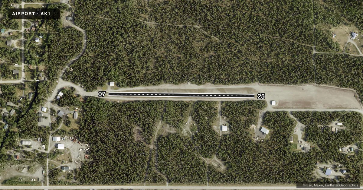
Airport sketch
Runways drawn to scale from FAA survey coordinates, rendered over satellite imagery. Not for navigation.
Approaches & charts
Services on the field
Fuel grades, oxygen, maintenance, ramp storage and lighting — as declared to the FAA by the airport operator.
Fuel & services
- Fuel
- Not available
Ramp & ground
- Transient storage
- Not published
- Landing fee
- No fee published
- Customs
- Not available
- Wind indicator
- Yes
- Segmented circle
- No
Fuel & FBOs
Cheapest 100LL and Jet A on the field and nearby. Always confirm with the FBO before taxi.
Airport notes
Surface conditions, obstructions, local procedures, lighting outages and other notes published with each FAA cycle.
General notes
- ROAD ALG N & S SIDE OF RWY.
- RWY COND UNMNT; VISUAL INSP RCMDD BFR LNDG.
Runway surface & condition
- 07/25SAFETY AREA CLR 1800 FT X 200 FT.
Approach & departure obstructions
- 07400 FT SAFETY AREA.
Other notes
- NSTD; YELLOW. UNRELBL.
- 07/25DIPS & 3IN ROCKS.
VFR map & nearby airports
VFR sectional. Tap any ICAO chip to open that airport.
Key facts · AK1
Answer card- ICAO
- AK1
- Name
- BUTTE MUNI
- Location
- PALMER, ALASKA
- Elevation
- 64 ft MSL
- Traffic pattern altitude
- 1,064 ft MSL (1,000 AGL)
- Control tower
- Non-towered (use CTAF)
- Total runways
- 1
- Longest runway
- 07/25 · 1,806 ft
- Published ILS approaches
- 0
- Published frequencies
- 1
- Magnetic variation
- 25°
- Current flight rules
- MVFR
- Current wind
- 000° at 3 kt
- Favored runway now
- RWY 07
Butte Muni Airport (AK1) is in Palmer, Alaska. The field elevation is 64 ft MSL. It has one runway. Runway 07/25 is 1,806 ft long with a gravel-dirt surface. There is no control tower. CTAF is 123.6.
No ILS approaches are published here. Pattern altitude is not published, so use the standard 1,000 ft AGL for light piston traffic unless the current Chart Supplement says otherwise. That puts the traffic pattern at 1,064 ft MSL based on the field elevation. The runway is short. It also has reported dips and 3-inch rocks on the surface. Runway condition is unmonitored, so a visual inspection before landing is a good idea.
The published remarks also note a road along the north and south sides of the runway. The wind indicator flag is nonstandard and yellow. It is unreliable. Runway 07 has a 400-foot safety area. The safety area for 07/25 is clear for 1,800 feet by 200 feet. There are no on-field FBOs listed, so plan on confirming services with the airport operator or the FBO directly by phone before you go. For current noise, curfew, or operational restrictions, check the current FAA Chart Supplement before flying in.