METAR & TAF CZO
CZO does not publish a METAR.
Showing the nearest reporting station: PAGK (GULKANA) · 32.8 NM away. Conditions at CZO may differ.
METAR · PAGK
Observed 10:53Z
PAGK 271053Z AUTO 17005KT 10SM CLR 09/08 A2983 RMK AO2 SLP103 T00940078 TSNO
- Wind
- 170° @ 5 kt
- Visibility
- 10 SM
- Temp / Dew
- 9°C / 8°C
- Altimeter
- 29.83 inHg
- Clouds
- CLR
- Density alt
- 1,699 ft
- Ceiling
- Unlimited
- Rules
- VFR
Airport info & contacts
Manager on record, flight service, ARTCC, attendance schedule and pattern altitude — published by the FAA and refreshed every 28 days.
Location
- From city
- 0 NM SW
- VFR sectional
- ANCHORAGE
- ARTCC
- ZAN · ANCHORAGE
- NOTAM facility
- ENA (NOTAM-D)
Airport manager
- Name
- CHAD HELLER
- Phone
- 907-822-3222
- Address
- P O BOX 7, GLENALLEN AK 99588
Flight service · Hours
- FSS ENA
- KENAI907-283-72111-866-864-1737
- Attendance
- Unattended
Frequencies
Tap any row to copy the frequency to your clipboard.
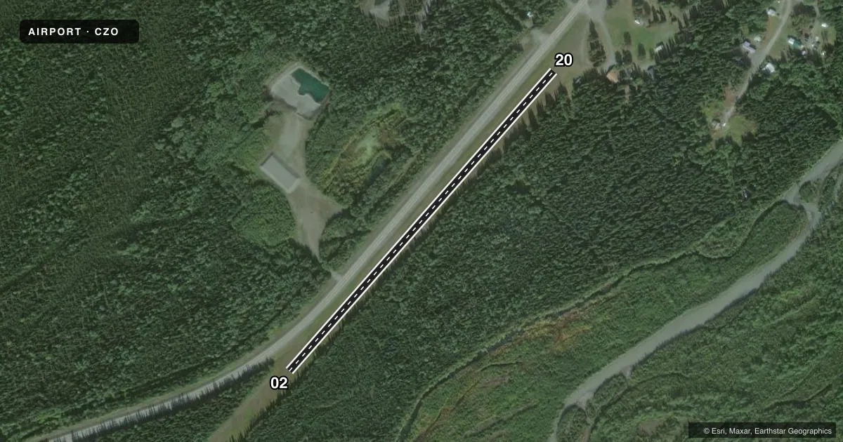
Runways & pattern
Full pagePattern entry · RWY 20
LEFT TRAFFICRunway end performance
| End | TORA | TODA | ASDA | LDA | VGSI | Approach lights | Obstruction |
|---|---|---|---|---|---|---|---|
| 02 | — | — | — | — | — | — | 60', trees, 0' from thr, 90' R of cntrln, slope 0 |
| 20 | — | — | — | — | — | — | 65', tree, 255' from thr, 31' R of cntrln, slope 4 |
Declared distances in feet. TORA = takeoff run available, TODA = takeoff distance, ASDA = accelerate-stop, LDA = landing distance.
Airport sketch
Runways drawn to scale from FAA survey coordinates, rendered over satellite imagery. Not for navigation.
Approaches & charts
Services on the field
Fuel grades, oxygen, maintenance, ramp storage and lighting — as declared to the FAA by the airport operator.
Fuel & services
- Fuel
- Not available
Ramp & ground
- Transient storage
- Not published
- Landing fee
- No fee published
- Customs
- Not available
- Wind indicator
- Yes
- Segmented circle
- No
Fuel & FBOs
Cheapest 100LL and Jet A on the field and nearby. Always confirm with the FBO before taxi.
Airport notes
Surface conditions, obstructions, local procedures, lighting outages and other notes published with each FAA cycle.
General notes
- RWY COND UNMNT; RCMD VISUAL INSP BFR LNDG.
- WX CAMERA AVBL ON INTERNET AT HTTPS://WEATHERCAMS.FAA.GOV
Runway surface & condition
- 02/20UNMNTND. HWY PARL W EDGE.
Approach & departure obstructions
- 02REFLECTIVE ORANGE CONES.
- 20REFLECTIVE ORANGE CONES.
- 20PWR LINE XS APCH 450 FT FM THR.
Other notes
- 02/203 FT GRASS & BRUSH. SOFT WHEN WET.
VFR map & nearby airports
VFR sectional. Tap any ICAO chip to open that airport.
Key facts · CZO
Answer card- ICAO
- CZO
- Name
- CHISTOCHINA
- Location
- CHISTOCHINA, ALASKA
- Elevation
- 1,860.7 ft MSL
- Traffic pattern altitude
- 2,860.7 ft MSL (1,000 AGL)
- Control tower
- Non-towered (use CTAF)
- Total runways
- 1
- Longest runway
- 02/20 · 2,060 ft
- Published ILS approaches
- 0
- Published frequencies
- 1
- Magnetic variation
- 21°
- Current flight rules
- VFR
- Current wind
- 170° at 5 kt
- Favored runway now
- RWY 20
Chistochina Airport sits in Chistochina, Alaska at 1,860.7 ft MSL. It has one runway. The longest is 2,060 ft. There is no control tower. CTAF is 122.9. No ILS approaches are published here, so plan for VFR or other non-ILS options only if they are current and appropriate for your aircraft.
The runway is 02/20. It is turf-gravel. The published pattern altitude is not listed, so use the standard 1,000 ft AGL for light piston operations unless the current Chart Supplement says otherwise. That puts the pattern about 2,860.7 ft MSL. The field is unmonitored, so a visual check before landing makes sense. Runway 02/20 is also reported as soft when wet. A highway parallels the west edge. Runway 20 has a power line crossing the approach about 450 ft from the threshold. Runway 02 and runway 20 are marked with reflective orange cones.
There are no on-field FBOs listed. Check the current Chart Supplement or call the airport operator before you go if you need fuel or other services. The airport has a weather camera online, which is useful for a quick look at surface conditions before departure or arrival. At this elevation in Alaska, performance planning matters. Watch density altitude, runway surface condition and your landing distance.