METAR & TAF L20
L20 does not publish a METAR.
Showing the nearest reporting station: PAEG (EAGLE) · 59.6 NM away. Conditions at L20 may differ.
METAR · PAEG
Observed 19:53Z
PAEG 271953Z AUTO 00000KT 10SM CLR 24/12 A2971 RMK AO2 SLP058 T02440122 PWINO TSNO $
- Wind
- 000° @ 0 kt
- Visibility
- 10 SM
- Temp / Dew
- 24°C / 12°C
- Altimeter
- 29.71 inHg
- Clouds
- CLR
- Density alt
- 2,415 ft
- Ceiling
- Unlimited
- Rules
- VFR
Airport info & contacts
Manager on record, flight service, ARTCC, attendance schedule and pattern altitude — published by the FAA and refreshed every 28 days.
Location
- From city
- 1 NM W
- VFR sectional
- DAWSON
- ARTCC
- ZAN · ANCHORAGE
- NOTAM facility
- FAI (NOTAM-D)
Airport manager
- Name
- PARK SUPERINTENDENT
- Phone
- 907-455-0646
- Address
- PO BOX 167, EAGLE AK 99738
Flight service · Hours
- FSS FAI
- FAIRBANKS907-474-07881-866-248-6516
- Attendance
- Unattended
Frequencies
Tap any row to copy the frequency to your clipboard.
Runways & pattern
Full pagePattern entry · RWY 01
LEFT TRAFFICRunway end performance
| End | TORA | TODA | ASDA | LDA | VGSI | Approach lights | Obstruction |
|---|---|---|---|---|---|---|---|
| 01 | — | — | — | — | — | — | 15', road, 0' from thr, 20' R of cntrln, slope 0 |
| 19 | — | — | — | — | — | — | 15', road, 0' from thr, 20' R of cntrln, slope 0 |
Declared distances in feet. TORA = takeoff run available, TODA = takeoff distance, ASDA = accelerate-stop, LDA = landing distance.
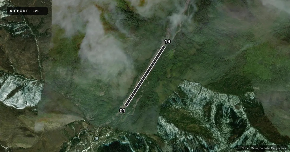
Airport sketch
Runways drawn to scale from FAA survey coordinates, rendered over satellite imagery. Not for navigation.
Approaches & charts
Services on the field
Fuel grades, oxygen, maintenance, ramp storage and lighting — as declared to the FAA by the airport operator.
Fuel & services
- Fuel
- Not available
Ramp & ground
- Transient storage
- Not published
- Wind indicator
- Yes
- Segmented circle
- No
Fuel & FBOs
Cheapest 100LL and Jet A on the field and nearby. Always confirm with the FBO before taxi.
Airport notes
Surface conditions, obstructions, local procedures, lighting outages and other notes published with each FAA cycle.
General notes
- RWY NOT MNTND WINTER & EARLY SPRING.
- RWY COND UNMNT. RCMD VISUAL INSP BFR USE.
- CTN: PAEW E EDGE OF RWY.
- 18 IN ROCKS IN RAMP & PRKG AREA. PRKG LTD W SIDE RWY S END.
- SUAIS - 125.3/126.3/1-800-758-8723.
- RWY IN VALLEY; RAPIDLY RISING TRRN W & E.
Runway surface & condition
- 01/19IREG WINDS PSBL. RWY IS DREDGED CREEK; SLOPES UPHILL TO S; 8 FT DREDGE TAILINGS BOTH SIDES FULL LEN.
Approach & departure obstructions
- 01THR MKD WITH CONES & REFLECTIVE PANELS.
- 19THR MKD WITH CONES & REFLECTIVE PANELS.
Other notes
- YUKON CHARLEY RIVERS NATIONAL PRESERVE.
- 01/19ROUGH; 6 IN ROCKS.
VFR map & nearby airports
VFR sectional. Tap any ICAO chip to open that airport.
Key facts · L20
Answer card- ICAO
- L20
- Name
- COAL CREEK
- Location
- YUKON CHARLEY RIVERS, ALASKA
- Elevation
- 867 ft MSL
- Traffic pattern altitude
- 1,867 ft MSL (1,000 AGL)
- Control tower
- Non-towered (use CTAF)
- Total runways
- 1
- Longest runway
- 01/19 · 3,900 ft
- Published ILS approaches
- 0
- Published frequencies
- 1
- Magnetic variation
- 30°
- Current flight rules
- VFR
- Current wind
- 000° at 0 kt
- Favored runway now
- –
Coal Creek Airport sits in Yukon Charley Rivers, Alaska. Field elevation is 867 ft MSL. The airport has one runway. Runway 01/19 is 3,900 ft long and gravel. There is no control tower. CTAF is 122.8. No ILS approaches are published.
Pattern altitude is not published. Use 1,000 ft AGL for light piston traffic unless the current Chart Supplement or local procedures say otherwise. The runway headings are magnetic. Runway 01 is marked at 32.9788517599756° magnetic. Runway 19 is marked at 212.978851759976° magnetic.
This is a rough backcountry field. Published remarks say the runway is a dredged creek with 8-foot tailings on both sides for the full length. The surface is rough with 6-inch rocks. The threshold is marked with cones and reflective panels on both ends. The runway slopes uphill to the south. Irregular winds are possible. The runway condition is unmonitored. A visual inspection before use is recommended. The runway is not maintained during winter and early spring.
There are no on-field FBOs listed. Plan to self-brief carefully before arrival. The runway sits in a valley with rapidly rising terrain to the west and east. Special use airspace information is available on frequencies 125.3 and 126.3 or by phone at 1-800-758-8723. Check the current Chart Supplement and contact the airport operator if you need current field status before you go.