METAR & TAF PAAY
PAAY does not publish a METAR.
Showing the nearest reporting station: PAEG (EAGLE) · 47.5 NM away. Conditions at PAAY may differ.
METAR · PAEG
Observed 17:14Z
PAEG 261714Z AUTO 00000KT 1/2SM HZ CLR 17/10 A2970 RMK AO2 T01720100 PWINO TSNO $
- Wind
- 000° @ 0 kt
- Visibility
- 0.5 SM
- Temp / Dew
- 17°C / 10°C
- Altimeter
- 29.70 inHg
- Clouds
- CLR
- Density alt
- 2,546 ft
- Ceiling
- Unlimited
- Rules
- LIFR
Airport info & contacts
Manager on record, flight service, ARTCC, attendance schedule and pattern altitude — published by the FAA and refreshed every 28 days.
Location
- From city
- 0 NM SW
- VFR sectional
- DAWSON
- ARTCC
- ZAN · ANCHORAGE
- NOTAM facility
- ORT (NOTAM-D)
Airport manager
- Name
- SAM JENNINGS
- Phone
- 907-883-5128
- Address
- P.O. BOX 356, TOK AK 99780
Flight service · Hours
- FSS ORT
- NORTHWAY907-778-22191-800-478-6611
- Attendance
- Unattended
Frequencies
Tap any row to copy the frequency to your clipboard.
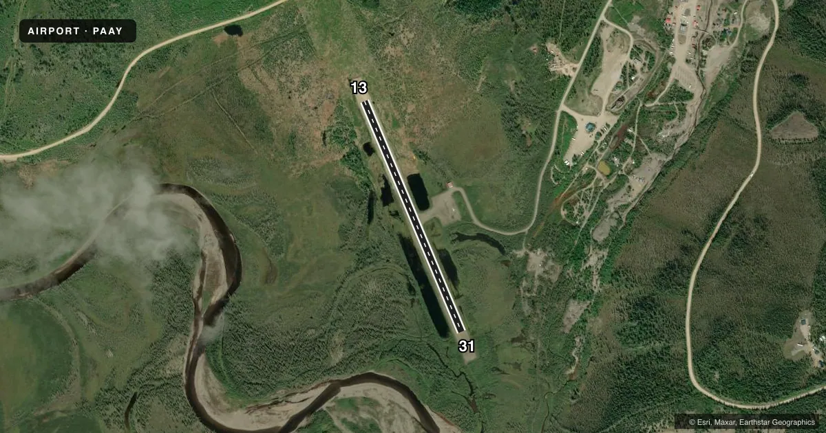
Runways & pattern
Full pagePattern entry · RWY 13
LEFT TRAFFICRunway end performance
| End | TORA | TODA | ASDA | LDA | VGSI | Approach lights | Obstruction |
|---|---|---|---|---|---|---|---|
| 13 | — | — | — | — | — | — | 8', brush, 0' from thr, 70' R of cntrln, slope 0 |
| 31 | — | — | — | — | — | — | 6', brush, 0' from thr, 67' R of cntrln, slope 0 |
Declared distances in feet. TORA = takeoff run available, TODA = takeoff distance, ASDA = accelerate-stop, LDA = landing distance.
Airport sketch
Runways drawn to scale from FAA survey coordinates, rendered over satellite imagery. Not for navigation.
Approaches & charts
Services on the field
Fuel grades, oxygen, maintenance, ramp storage and lighting — as declared to the FAA by the airport operator.
Fuel & services
- Fuel
- MOGAS
Ramp & ground
- Transient storage
- Tie-down
- Landing fee
- No fee published
- Customs
- Not available
- Wind indicator
- Yes
- Segmented circle
- Yes
Fuel & FBOs
Cheapest 100LL and Jet A on the field and nearby. Always confirm with the FBO before taxi.
Airport notes
Surface conditions, obstructions, local procedures, lighting outages and other notes published with each FAA cycle.
General notes
- RWY COND UNMNT; RCMD VISUAL INSP BFR LNDG.
- CTN: FIRE CREWS & HEL DURG SUMMER.
- SNOW REMOVAL OPS - MNT CTAF.
- SUAIS - 125.3/126.3 (1-800-758-8723).
- EXP TURB DURG APCH.
- WATERFOWL ON & INVOF RWY IN SUMMER.
Approach & departure obstructions
- 13THR PANELS & CONES.
- 31THR PANELS & CONES.
Other notes
- 13/31DIP IN CNTR; UPSLOPE TO BOTH ENDS.
VFR map & nearby airports
VFR sectional. Tap any ICAO chip to open that airport.
Key facts · PAAY
Answer card- ICAO
- PAAY
- Name
- CHICKEN
- Location
- CHICKEN, ALASKA
- Elevation
- 1,640 ft MSL
- Traffic pattern altitude
- 2,640 ft MSL (1,000 AGL)
- Control tower
- Non-towered (use CTAF)
- Total runways
- 1
- Longest runway
- 13/31 · 2,500 ft
- Published ILS approaches
- 0
- Published frequencies
- 2
- Magnetic variation
- 30°
- Current flight rules
- LIFR
- Current wind
- 000° at 0 kt
- Favored runway now
- –