METAR & TAF 3T4
3T4 does not publish a METAR.
Showing the nearest reporting station: PFTO (TOK JUNCTION) · 17.0 NM away. Conditions at 3T4 may differ.
METAR · PFTO
Observed 16:56Z
PFTO 271656Z AUTO 18005KT 10SM CLR 18/11 A2978 RMK AO2 SLP594 T01830111 $
- Wind
- 180° @ 5 kt
- Visibility
- 10 SM
- Temp / Dew
- 18°C / 11°C
- Altimeter
- 29.78 inHg
- Clouds
- CLR
- Density alt
- 2,606 ft
- Ceiling
- Unlimited
- Rules
- VFR
Airport info & contacts
Manager on record, flight service, ARTCC, attendance schedule and pattern altitude — published by the FAA and refreshed every 28 days.
Location
- From city
- 1 NM S
- VFR sectional
- ANCHORAGE
- ARTCC
- ZAN · ANCHORAGE
- NOTAM facility
- ORT (NOTAM-D)
Airport manager
- Name
- SAM JENNINGS
- Phone
- 907-883-5128
- Address
- P.O. BOX 356, TOK AK 99780
Flight service · Hours
- FSS ORT
- NORTHWAY907-778-22191-800-478-6611
- Attendance
- Unattended
Frequencies
Tap any row to copy the frequency to your clipboard.
Runways & pattern
Full pagePattern entry · RWY 08
LEFT TRAFFICRunway end performance
| End | TORA | TODA | ASDA | LDA | VGSI | Approach lights | Obstruction |
|---|---|---|---|---|---|---|---|
| 08 | — | — | — | — | — | — | 4', brush, 0' from thr, 50' R of cntrln, slope 1 |
| 26 | — | — | — | — | — | — | 4', brush, 0' from thr, 70' R of cntrln, slope 1 |
Declared distances in feet. TORA = takeoff run available, TODA = takeoff distance, ASDA = accelerate-stop, LDA = landing distance.
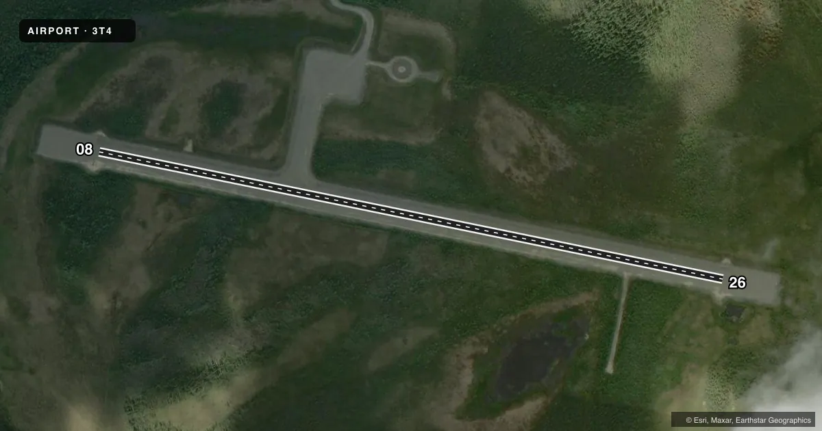
Airport sketch
Runways drawn to scale from FAA survey coordinates, rendered over satellite imagery. Not for navigation.
Approaches & charts
Services on the field
Fuel grades, oxygen, maintenance, ramp storage and lighting — as declared to the FAA by the airport operator.
Fuel & services
- Fuel
- Not available
Ramp & ground
- Transient storage
- Tie-down
- Lighting schedule
- SEE RMK
- Beacon schedule
- SS-SR
- Beacon
- White / Green (civil land)(WG)
- Wind indicator
- Lighted
- Segmented circle
- Yes
Fuel & FBOs
Cheapest 100LL and Jet A on the field and nearby. Always confirm with the FBO before taxi.
Airport notes
Surface conditions, obstructions, local procedures, lighting outages and other notes published with each FAA cycle.
General notes
- RWY COND UNMNT, RCMD VISUAL INSP BFR USE.
- SKIS NOT RCMDD.
Lighting notes
- ACTVT MIRL RWY 08/26 - CTAF.
Other notes
- NO ROPES.
VFR map & nearby airports
VFR sectional. Tap any ICAO chip to open that airport.
Key facts · 3T4
Answer card- ICAO
- 3T4
- Name
- TETLIN
- Location
- TETLIN, ALASKA
- Elevation
- 1,670.9 ft MSL
- Traffic pattern altitude
- 2,670.9 ft MSL (1,000 AGL)
- Control tower
- Non-towered (use CTAF)
- Total runways
- 1
- Longest runway
- 08/26 · 3,300 ft
- Published ILS approaches
- 0
- Published frequencies
- 1
- Magnetic variation
- 22°
- Current flight rules
- VFR
- Current wind
- 180° at 5 kt
- Favored runway now
- RWY 08
Tetlin Airport (3T4) sits in Tetlin, Alaska. Field elevation is 1,670.9 ft MSL. The airport has one runway. Runway 08/26 is 3,300 ft long and gravel. The runway headings are magnetic 102° and 282°. There is no control tower. CTAF is 122.9.
No ILS approaches are published here. Pattern altitude is not published, so use the standard 1,000 ft AGL pattern unless local conditions or the current Chart Supplement say otherwise. At this field that works out to about 2,670.9 ft MSL for light piston traffic. Runway condition is unmonitored. A visual check before landing is a good idea. Medium intensity runway lights on 08/26 are activated by CTAF. Skis are not recommended. No ropes are available for tie-down.
There are no on-field FBOs listed. Plan on self-sufficiency and verify services with the airport operator before you go. Tetlin is a high-elevation Alaska strip, so density altitude and performance planning matter. The gravel surface also calls for normal soft-field technique and a careful look at braking and acceleration on departure.