METAR & TAF PAOR
Current METAR
Observed 16:53Z
PAOR 271653Z AUTO 00000KT 10SM SCT120 17/12 A2978
- Wind
- 000° @ 0 kt
- Visibility
- 10 SM
- Temp / Dew
- 17°C / 12°C
- Altimeter
- 29.78 inHg
- Clouds
- SCT
- Density alt
- 2,547 ft
- Ceiling
- Unlimited
- Rules
- VFR
Airport info & contacts
Manager on record, flight service, ARTCC, attendance schedule and pattern altitude — published by the FAA and refreshed every 28 days.
Location
- From city
- 0 NM S
- VFR sectional
- ANCHORAGE
- ARTCC
- ZAN · ANCHORAGE
- NOTAM facility
- ORT (NOTAM-D)
Airport manager
- Name
- SAM JENNINGS
- Phone
- 907-883-5128
- Address
- BOX 356, TOK AK 99780
Flight service · Hours
- FSS ORT
- NORTHWAY907-778-22191-800-478-6611
- Attendance
- Unattended
Frequencies
Tap any row to copy the frequency to your clipboard.
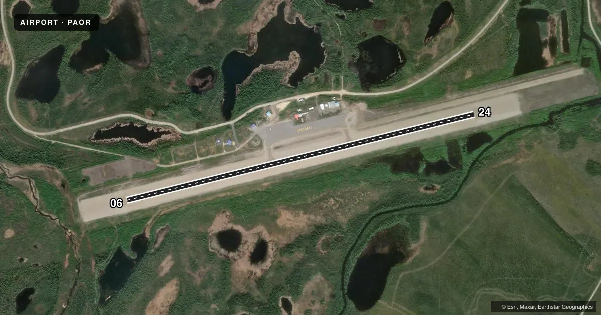
Runways & pattern
Full pagePattern entry · RWY 06
LEFT TRAFFICRunway end performance
| End | TORA | TODA | ASDA | LDA | VGSI | Approach lights | Obstruction |
|---|---|---|---|---|---|---|---|
| 06 | — | — | — | — | PAPI 4-box left(3°) | — | 61', trees, 2029' from thr, slope 30 |
| 24 | — | — | — | — | PAPI 4-box left(3°) | — | 60', trees, 1195' from thr, 425' R of cntrln, slope 16 |
Declared distances in feet. TORA = takeoff run available, TODA = takeoff distance, ASDA = accelerate-stop, LDA = landing distance.
Airport sketch
Runways drawn to scale from FAA survey coordinates, rendered over satellite imagery. Not for navigation.
Approaches & charts
Services on the field
Fuel grades, oxygen, maintenance, ramp storage and lighting — as declared to the FAA by the airport operator.
Fuel & services
- Fuel
- Not available
Ramp & ground
- Transient storage
- Hangar
- Landing fee
- No fee published
- Customs
- Not available
- Lighting schedule
- SEE RMK
- Beacon schedule
- SS-SR
- Beacon
- White / Green (civil land)(WG)
- Wind indicator
- Lighted
- Segmented circle
- Yes
Fuel & FBOs
Cheapest 100LL and Jet A on the field and nearby. Always confirm with the FBO before taxi.
Airport notes
Surface conditions, obstructions, local procedures, lighting outages and other notes published with each FAA cycle.
General notes
- WINTER SN REMOVAL OPS - CTAF.
- FLOATPLANE CUST SVC AVBL YARGER LAKE 8 NM E.
- SUAIS - 125.3/126.3 OR 800-758-8723.
- RWY COND UNMN; RCMD VISUAL INSP PRIOR TO LNDG.
- NORTHWAY & KNOB RIDGE WX CAMERAS AVBL AT HTTPS://WEATHERCAMS.FAA.GOV/.
- FOREIGN ARR ORT/PAOR OR YARGER LAKE +2 HR PPR; NMLLY 1800Z-0000Z - U.S. CUSTOMS 907-774-2242/2252.
- ELEC FILED EAPIS MANIFEST REQ PRIOR TO DEP.
- COLD TEMPERATURE AIRPORT. ALTITUDE CORRECTION REQUIRED AT OR BELOW -48C.
Lighting notes
- ACTVT REIL RWY 24; PAPI RWY 06 & 24; MIRL RWY 06/24 - CTAF.
Runway surface & condition
- 06/24FQT VRB STRONG CROSSWIND.
Approach & departure obstructions
- 24SKI STRIP PARL & ADJ THR NW SIDE.
Other notes
- MAY 1-SEP 30; 0815-1745; AFT HR - FAI FSS.
VFR map & nearby airports
VFR sectional. Tap any ICAO chip to open that airport.
Key facts · PAOR
Answer card- ICAO
- PAOR
- Name
- NORTHWAY
- Location
- NORTHWAY, ALASKA
- Elevation
- 1,720.1 ft MSL
- Traffic pattern altitude
- 2,720.1 ft MSL (1,000 AGL)
- Control tower
- Non-towered (use CTAF)
- Total runways
- 1
- Longest runway
- 06/24 · 5,100 ft
- Published ILS approaches
- 0
- Published frequencies
- 1
- Magnetic variation
- 17°
- Current flight rules
- VFR
- Current wind
- 000° at 0 kt
- Favored runway now
- –
Northway Airport sits in Northway, Alaska at 1,720.1 ft MSL. It has one runway, 06/24, which is 5,100 ft long. There is no control tower. CTAF is 123.6. No ILS approaches are published here, so plan with the current chart and weather in mind.
The published pattern altitude is not given. Use standard 1,000 ft AGL for light piston operations unless the current FAA Chart Supplement says otherwise. The field uses magnetic variation of 17°. Runway 24 has REILs. Both runway ends have PAPI. Medium intensity runway lights are on 06 and 24. They are controlled on CTAF.
This is a cold temperature airport. Altitude correction is required at or below minus 48 C. Runway condition is unmonitored. A visual inspection before landing is recommended. Strong and variable crosswinds are reported on runway 06/24. A ski strip also parallels and sits next to the northwest side of runway 24. Foreign arrivals need a two-hour prior permission request, normally between 1800Z and 0000Z. If you are arriving from outside the U.S., verify the current Customs process before you go.