METAR & TAF TSG
TSG does not publish a METAR.
Showing the nearest reporting station: PFTO (TOK JUNCTION) · 10.5 NM away. Conditions at TSG may differ.
METAR · PFTO
Observed 15:56Z
PFTO 271556Z AUTO VRB04KT 10SM CLR 16/11 A2978 RMK AO2 SLP595 T01610111 $
- Wind
- VAR @ 4 kt
- Visibility
- 10 SM
- Temp / Dew
- 16°C / 11°C
- Altimeter
- 29.78 inHg
- Clouds
- CLR
- Density alt
- 2,227 ft
- Ceiling
- Unlimited
- Rules
- VFR
Airport info & contacts
Manager on record, flight service, ARTCC, attendance schedule and pattern altitude — published by the FAA and refreshed every 28 days.
Location
- From city
- 1 NM S
- VFR sectional
- ANCHORAGE
- ARTCC
- ZAN · ANCHORAGE
- NOTAM facility
- ORT (NOTAM-D)
Airport manager
- Name
- LANORE HEPPLER
- Phone
- 907-474-2320
- Address
- 1150 UNIVERSITY AVE, FAIBANKS AK 99709
Flight service · Hours
- FSS ORT
- NORTHWAY907-778-22191-800-478-6611
- Attendance
- Unattended
Frequencies
Tap any row to copy the frequency to your clipboard.
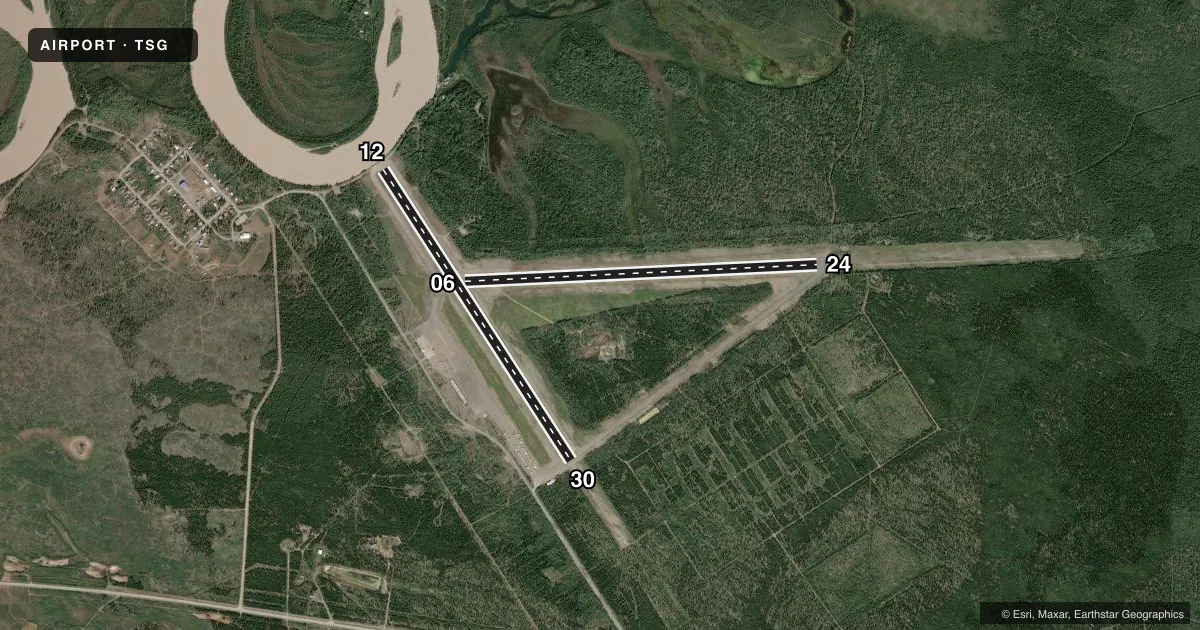
Runways & pattern
Full pagePattern entry · RWY 30
LEFT TRAFFIC| Runway | Heading (°M) | Length | Surface | Traffic |
|---|---|---|---|---|
| 06/24 | 58° / 238° | 4,963 ft | ASPH | Standard L |
| 12/30Favored | 118° / 298° | 4,871 ft | ASPH | Standard L |
Runway end performance
| End | TORA | TODA | ASDA | LDA | VGSI | Approach lights | Obstruction |
|---|---|---|---|---|---|---|---|
| 06 | — | — | — | — | — | — | 50', trees, 990' from thr, 225' R of cntrln, slope 15 |
| 24 | — | — | — | — | — | — | 43', trees, 200' from thr, 200' R of cntrln, slope 0 |
| 12 | — | — | — | — | — | — | 56', trees, 630' from thr, 0' R of cntrln, slope 7 |
| 30 | — | — | — | — | — | — | 31', trees, 200' from thr, 135' R of cntrln, slope 0 |
Declared distances in feet. TORA = takeoff run available, TODA = takeoff distance, ASDA = accelerate-stop, LDA = landing distance.
Airport sketch
Runways drawn to scale from FAA survey coordinates, rendered over satellite imagery. Not for navigation.
Approaches & charts
Services on the field
Fuel grades, oxygen, maintenance, ramp storage and lighting — as declared to the FAA by the airport operator.
Fuel & services
- Fuel
- Not available
Ramp & ground
- Transient storage
- Not published
- Landing fee
- No fee published
- Customs
- Not available
- Wind indicator
- Yes
- Segmented circle
- No
Fuel & FBOs
Cheapest 100LL and Jet A on the field and nearby. Always confirm with the FBO before taxi.
Airport notes
Surface conditions, obstructions, local procedures, lighting outages and other notes published with each FAA cycle.
General notes
- AIR OPS & FIRE SUPPORT SUMMER MONTHS. RWY MAINT NA IN WINTER.
- SUAIS - 125.3/126.3/1-800-758-8723.
Approach & departure obstructions
- 12ROAD XS APCH 60 FT FM THR; RIVER XS APCH 100 FT FM RWY END.
- 24APCH: 300 FT SWATH CUT THRU TREES.
- 30APCH: 280 FT SWATH CUT THRU TREES.
- 06FADED.
- 12FADED.
- 24FADED.
- 30FADED.
- 06YELLOW NRS & CNTRLN.
- 12YELLOW NRS & CNTRLN.
- 24YELLOW NRS & CNTRLN.
- 30YELLOW NRS & CNTRLN.
Other notes
- OWNERSTEESE/WHITE MOUNTAIN DISTRICT.
- 06/24CRACKED WITH VEGETATION.
- 12/30CRACKED WITH VEGETATION.
VFR map & nearby airports
VFR sectional. Tap any ICAO chip to open that airport.
Key facts · TSG
Answer card- ICAO
- TSG
- Name
- TANACROSS
- Location
- TANACROSS, ALASKA
- Elevation
- 1,559 ft MSL
- Traffic pattern altitude
- 2,559 ft MSL (1,000 AGL)
- Control tower
- Non-towered (use CTAF)
- Total runways
- 2
- Longest runway
- 06/24 · 4,963 ft
- Published ILS approaches
- 0
- Published frequencies
- 1
- Magnetic variation
- 29°
- Current flight rules
- VFR
- Current wind
- 000° at 4 kt
- Favored runway now
- RWY 30
Tanacross Airport sits in Tanacross, Alaska at 1,559 ft MSL. It has two asphalt runways. The longest is 06/24 at 4,963 ft. The other runway is 12/30 at 4,871 ft. There is no control tower. CTAF is 122.8.
No ILS approaches are published here. Pattern altitude is not published, so use 1,000 ft AGL as the normal light-piston reference unless the current FAA Chart Supplement says otherwise. With the field elevation at 1,559 ft MSL, that puts the standard pattern reference at 2,559 ft MSL.
There are no on-field FBOs listed. Check with the airport operator or the field on CTAF for current services before you go. Published remarks note cracked pavement with vegetation on both runways. Runway 06/24 is also reported with a 300-foot swath cut through trees on the 24 approach. Runway 12 has a road crossing the approach 60 ft from the threshold. A river crosses the approach 100 ft from the runway end of 12. Summer air operations and fire support are available. Runway maintenance is not available in winter. This is a remote Alaska field, so plan for local weather, runway condition and seasonal support before arrival.