METAR & TAF PAAX
PAAX does not publish a METAR.
Showing the nearest reporting station: PAGK (GULKANA) · 44.9 NM away. Conditions at PAAX may differ.
METAR · PAGK
Observed 15:53Z
PAGK 271553Z AUTO 00000KT 10SM CLR 11/08 A2985 RMK AO2 SLP109 T01060083 TSNO
- Wind
- 000° @ 0 kt
- Visibility
- 10 SM
- Temp / Dew
- 11°C / 8°C
- Altimeter
- 29.85 inHg
- Clouds
- CLR
- Density alt
- 296 ft
- Ceiling
- Unlimited
- Rules
- VFR
Airport info & contacts
Manager on record, flight service, ARTCC, attendance schedule and pattern altitude — published by the FAA and refreshed every 28 days.
Location
- From city
- 4 NM N
- VFR sectional
- ANCHORAGE
- ARTCC
- ZAN · ANCHORAGE
- NOTAM facility
- ENA (NOTAM-D)
Airport manager
- Name
- CHAD HELLER
- Phone
- 907-822-3222
- Address
- PO BOX 7, GLENALLEN AK 99588
Flight service · Hours
- FSS ENA
- KENAI907-283-72111-866-864-1737
- Attendance
- Unattended
Frequencies
Tap any row to copy the frequency to your clipboard.
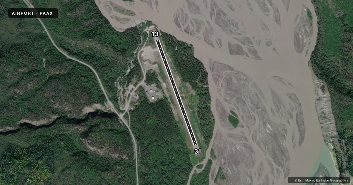
Runways & pattern
Full pagePattern entry · RWY 13
LEFT TRAFFICRunway end performance
| End | TORA | TODA | ASDA | LDA | VGSI | Approach lights | Obstruction |
|---|---|---|---|---|---|---|---|
| 13 | — | — | — | — | — | — | 10', brush, 0' from thr, 85' R of cntrln, slope 0 |
| 31 | — | — | — | — | — | — | 6', brush, 0' from thr, 80' R of cntrln, slope 0 |
Declared distances in feet. TORA = takeoff run available, TODA = takeoff distance, ASDA = accelerate-stop, LDA = landing distance.
Airport sketch
Runways drawn to scale from FAA survey coordinates, rendered over satellite imagery. Not for navigation.
Approaches & charts
Services on the field
Fuel grades, oxygen, maintenance, ramp storage and lighting — as declared to the FAA by the airport operator.
Fuel & services
- Fuel
- Not available
Ramp & ground
- Transient storage
- Tie-down
- Landing fee
- No fee published
- Customs
- Not available
- Wind indicator
- Yes
- Segmented circle
- Yes
Fuel & FBOs
Cheapest 100LL and Jet A on the field and nearby. Always confirm with the FBO before taxi.
Airport notes
Surface conditions, obstructions, local procedures, lighting outages and other notes published with each FAA cycle.
General notes
- RWY COND UMNT; RCMD VISUAL INSP BFR LNDG.
- 20 FT GRVL RIDGE W SIDE OF RWY.
- LINE OF SIGHT BTN RWY ENDS NA.
- WX CAMERA AVBL ON INTERNET AT HTTPS://WEATHERCAMS.FAA.GOV.
Approach & departure obstructions
- 31DOWNHILL SLOPE TO THE NE.
Other notes
- 13/313 FT BRUSH TO 20 FT BOTH SIDES OF CNTRLN.
- 13/31SHOULDERS SLOPE OFF BOTH SIDES.
VFR map & nearby airports
VFR sectional. Tap any ICAO chip to open that airport.
Key facts · PAAX
Answer card- ICAO
- PAAX
- Name
- CHITINA
- Location
- CHITINA, ALASKA
- Elevation
- 556 ft MSL
- Traffic pattern altitude
- 1,556 ft MSL (1,000 AGL)
- Control tower
- Non-towered (use CTAF)
- Total runways
- 1
- Longest runway
- 13/31 · 2,850 ft
- Published ILS approaches
- 0
- Published frequencies
- 1
- Magnetic variation
- 27°
- Current flight rules
- VFR
- Current wind
- 000° at 0 kt
- Favored runway now
- –