METAR & TAF AK0
AK0 does not publish a METAR.
Showing the nearest reporting station: PACV (MERLE K (MUDHOLE) SMITH) · 87.3 NM away. Conditions at AK0 may differ.
METAR · PACV
Observed 15:53Z
PACV 261553Z 00000KT 2 1/2SM BR BCFG OVC003 09/09 A2981 RMK AO2 SLP094 T00940089
- Wind
- 000° @ 0 kt
- Visibility
- 0.5 SM
- Temp / Dew
- 9°C / 9°C
- Altimeter
- 29.81 inHg
- Clouds
- OVC
- Density alt
- 748 ft
- Ceiling
- 300 ft AGL
- Rules
- LIFR
Airport info & contacts
Manager on record, flight service, ARTCC, attendance schedule and pattern altitude — published by the FAA and refreshed every 28 days.
Location
- From city
- 13 NM SE
- VFR sectional
- ANCHORAGE
- ARTCC
- ZAN · ANCHORAGE
- NOTAM facility
- ENA (NOTAM-D)
Airport manager
- Name
- DANNY ROSENKRANS
- Phone
- 907-822-7240
- Address
- BOX 493, COPPER CENTER AK 99573
Flight service · Hours
- FSS ENA
- KENAI907-283-72111-866-864-1737
- Attendance
- Unattended
Frequencies
Tap any row to copy the frequency to your clipboard.
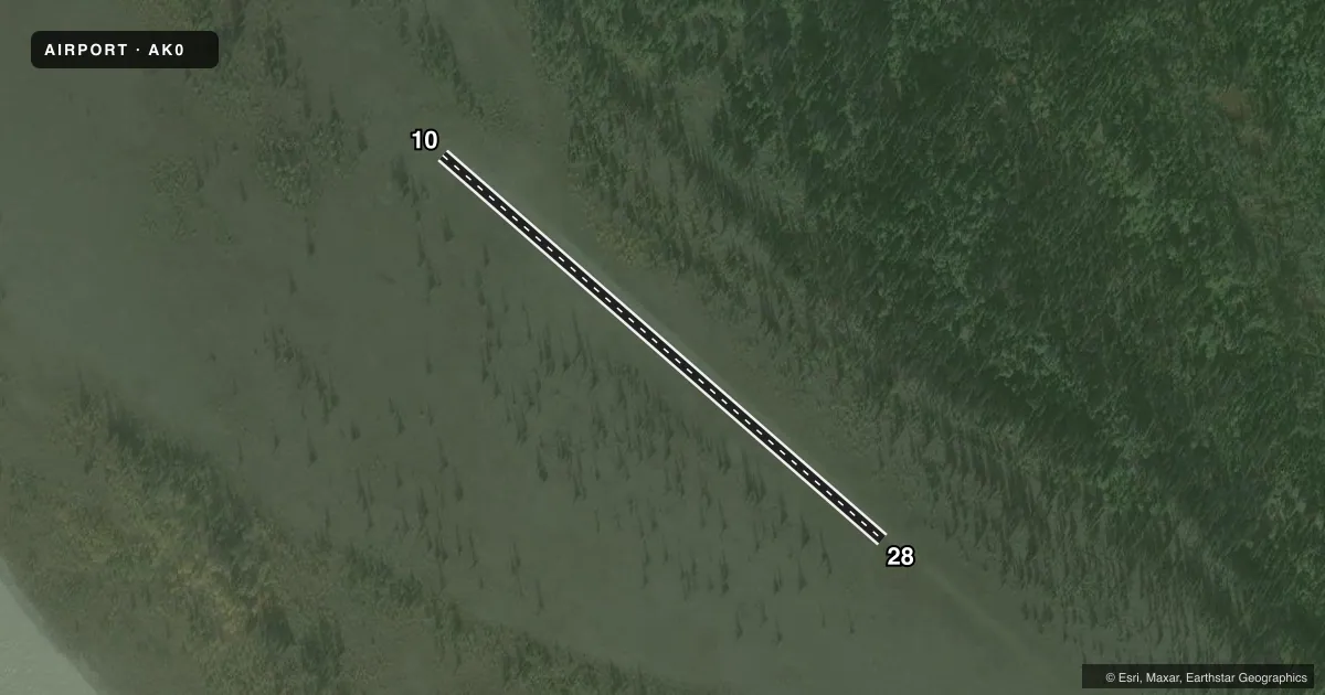
Runways & pattern
Full pagePattern entry · RWY 10
LEFT TRAFFICRunway end performance
| End | TORA | TODA | ASDA | LDA | VGSI | Approach lights | Obstruction |
|---|---|---|---|---|---|---|---|
| 10 | — | — | — | — | — | — | 40', tree, 0' from thr, 50' R of cntrln, slope 0 |
| 28 | — | — | — | — | — | — | 50', tree, 0' from thr, 85' R of cntrln, slope 0 |
Declared distances in feet. TORA = takeoff run available, TODA = takeoff distance, ASDA = accelerate-stop, LDA = landing distance.
Airport sketch
Runways drawn to scale from FAA survey coordinates, rendered over satellite imagery. Not for navigation.
Approaches & charts
Services on the field
Fuel grades, oxygen, maintenance, ramp storage and lighting — as declared to the FAA by the airport operator.
Fuel & services
- Fuel
- Not available
- Oxygen (bottled)
- Not available
- Oxygen (bulk)
- Not available
- Airframe repair
- Not available
- Power plant repair
- Not available
Ramp & ground
- Transient storage
- Not published
- Landing fee
- No fee published
- Customs
- Not available
- Wind indicator
- No
- Segmented circle
- No
Fuel & FBOs
Cheapest 100LL and Jet A on the field and nearby. Always confirm with the FBO before taxi.
Airport notes
Surface conditions, obstructions, local procedures, lighting outages and other notes published with each FAA cycle.
General notes
- SUBJ TO TURBC IN ANY WIND.
- RY SUITABLE ONLY FOR CONVENTIONAL GEAR ACFT.
- RY CONDITION NOT MONITORED, RCMD VISUAL INSPECTION PRIOR TO LANDING.
Runway surface & condition
- 10/28RY IS AN UNIMPROVED RIVER GRAVEL BAR
Other notes
- 10/28RY SURFACE VERY ROUGH. ROCKS UP TO 15 IN DIA.
VFR map & nearby airports
VFR sectional. Tap any ICAO chip to open that airport.
Key facts · AK0
Answer card- ICAO
- AK0
- Name
- JAKES BAR
- Location
- MCCARTHY, ALASKA
- Elevation
- 1,074 ft MSL
- Traffic pattern altitude
- 2,074 ft MSL (1,000 AGL)
- Control tower
- Non-towered (use CTAF)
- Total runways
- 1
- Longest runway
- 10/28 · 1,000 ft
- Published ILS approaches
- 0
- Published frequencies
- 1
- Magnetic variation
- 28°
- Current flight rules
- LIFR
- Current wind
- 000° at 0 kt
- Favored runway now
- –
Jakes Bar (AK0) sits near McCarthy, Alaska. Field elevation is 1,074 ft MSL. The airport has one runway. Runway 10/28 is 1,000 ft long and gravel. There is no control tower. CTAF is 122.9. No ILS approaches are published.
Pattern altitude is not published. Use the standard 1,000 ft AGL pattern for light piston aircraft unless local conditions or the current Chart Supplement say otherwise. The field is in a remote part of Alaska. Expect short-field planning. Expect limited margin. Check the surface before you commit.
The published remarks matter here. The runway is an unimproved river gravel bar. It is very rough. Rocks up to 15 inches in diameter are reported. It is suitable only for conventional gear aircraft. Runway condition is not monitored. A visual inspection before landing is recommended. Turbulence can show up in any wind.
No on-field FBOs are listed. Plan on self-sufficiency. Verify current field conditions with the airport operator before arrival. For any change in published procedures or local restrictions, check the current FAA Chart Supplement before you go.