METAR & TAF CZN
CZN does not publish a METAR.
Showing the nearest reporting station: CYXQ (BEAVER CREEK) · 38.8 NM away. Conditions at CZN may differ.
METAR · CYXQ
Observed 22:00Z
CYXQ 262200Z VRB03KT 20SM BKN030 OVC250 18/10 A2974 RMK CU6CI2 /LAST STFD OBS/NXT 271600Z/ SLP083 DENSITY ALT 3200FT
- Wind
- VAR @ 3 kt
- Visibility
- 20 SM
- Temp / Dew
- 18°C / 10°C
- Altimeter
- 29.74 inHg
- Clouds
- OVC
- Density alt
- 4,735 ft
- Ceiling
- 3,000 ft AGL
- Rules
- MVFR
Airport info & contacts
Manager on record, flight service, ARTCC, attendance schedule and pattern altitude — published by the FAA and refreshed every 28 days.
Location
- From city
- 0 NM N
- VFR sectional
- ANCHORAGE
- ARTCC
- ZAN · ANCHORAGE
- NOTAM facility
- ORT (NOTAM-D)
Airport manager
- Name
- CHAD HELLER
- Phone
- 907-822-3222
- Address
- P.O. BOX 7, GLENNALLEN AK 99588
Flight service · Hours
- FSS ORT
- NORTHWAY907-778-22191-800-478-6611
- Attendance
- Unattended
Frequencies
Tap any row to copy the frequency to your clipboard.
Runways & pattern
Full pagePattern entry · RWY 30
LEFT TRAFFICRunway end performance
| End | TORA | TODA | ASDA | LDA | VGSI | Approach lights | Obstruction |
|---|---|---|---|---|---|---|---|
| 12 | — | — | — | — | — | — | 60', trees, 0' from thr, 110' R of cntrln, slope 0 |
| 30 | — | — | — | — | — | — | 30', trees, 0' from thr, 60' R of cntrln, slope 0 |
Declared distances in feet. TORA = takeoff run available, TODA = takeoff distance, ASDA = accelerate-stop, LDA = landing distance.
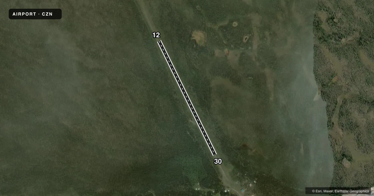
Airport sketch
Runways drawn to scale from FAA survey coordinates, rendered over satellite imagery. Not for navigation.
Approaches & charts
Services on the field
Fuel grades, oxygen, maintenance, ramp storage and lighting — as declared to the FAA by the airport operator.
Fuel & services
- Fuel
- Not available
Ramp & ground
- Transient storage
- Tie-down
- Landing fee
- No fee published
- Customs
- Not available
- Wind indicator
- Yes
- Segmented circle
- No
Fuel & FBOs
Cheapest 100LL and Jet A on the field and nearby. Always confirm with the FBO before taxi.
Airport notes
Surface conditions, obstructions, local procedures, lighting outages and other notes published with each FAA cycle.
General notes
- RWY COND UNMNT; RCMND VISUAL INSP BFR LNDG.
- VEHICLE TRAIL W SIDE OF RWY.
- SKIS ONLY WINTER.
- WILDLIFE INVOF RWY.
- ALERT: TWO PVT AIRSTRIPS PERPENDICULAR TO RWY 12 & 30 APCH.
Approach & departure obstructions
- 12THR & EDGE CONES.
- 30THR & EDGE CONES.
Other notes
- WINDSOCK PSBLY UNRELIABLE DUE TO TREES.
- 12/3024 IN BRUSH, 5 IN LOOSE ROCK, RUTS & DEPRESSIONS.
VFR map & nearby airports
VFR sectional. Tap any ICAO chip to open that airport.
Key facts · CZN
Answer card- ICAO
- CZN
- Name
- CHISANA
- Location
- CHISANA, ALASKA
- Elevation
- 3,348 ft MSL
- Traffic pattern altitude
- 4,348 ft MSL (1,000 AGL)
- Control tower
- Non-towered (use CTAF)
- Total runways
- 1
- Longest runway
- 12/30 · 3,000 ft
- Published ILS approaches
- 0
- Published frequencies
- 1
- Magnetic variation
- 29°
- Current flight rules
- MVFR
- Current wind
- 000° at 3 kt
- Favored runway now
- RWY 30
Chisana Airport sits in Chisana, Alaska at 3,348 ft MSL. It has one runway, 12/30, which is 3,000 ft long and surfaced in turf-gravel. The field is uncontrolled. CTAF is 122.9. No ILS approaches are published here.
Pattern altitude is not published. Use the standard 1,000 ft AGL pattern for light piston traffic unless the current Chart Supplement says otherwise. The published runway headings are magnetic. Runway 12 is 153.912155992488° magnetic. Runway 30 is 333.912155992488° magnetic.
This is a rough-field environment. The Chart Supplement notes brush, loose rock, ruts and depressions on runway 12/30. Runway condition is unmonitored, so a visual inspection before landing is a smart call. Wildlife is reported near the runway. Two private airstrips sit perpendicular to the approach paths for runways 12 and 30. The windsock may be unreliable because of trees. Runway 12 and runway 30 thresholds and edges are marked with cones. Skis are for winter use only.
No on-field FBOs are listed. Plan on self-sufficiency. Verify current field conditions with the airport operator before you go. In this part of Alaska, elevation and surface condition matter. Expect a short-field mindset. Plan carefully for performance. Give the runway a close look before committing to landing.