METAR & TAF PAEG
Current METAR
Observed 12:53Z
PAEG 271253Z AUTO 00000KT 10SM CLR 09/08 A2976 RMK AO2 SLP079 T00890078 PWINO TSNO $
- Wind
- 000° @ 0 kt
- Visibility
- 10 SM
- Temp / Dew
- 9°C / 8°C
- Altimeter
- 29.76 inHg
- Clouds
- CLR
- Density alt
- 603 ft
- Ceiling
- Unlimited
- Rules
- VFR
Airport info & contacts
Manager on record, flight service, ARTCC, attendance schedule and pattern altitude — published by the FAA and refreshed every 28 days.
Location
- From city
- 2 NM E
- VFR sectional
- DAWSON
- ARTCC
- ZAN · ANCHORAGE
- NOTAM facility
- EAA (NOTAM-D)
Airport manager
- Name
- SAM JENNINGS
- Phone
- 907-883-5128
- Address
- P O BOX 356, TOK AK 99780
Flight service · Hours
- FSS ORT
- NORTHWAY907-778-22191-800-478-6611
- Attendance
- Unattended
Frequencies
Tap any row to copy the frequency to your clipboard.
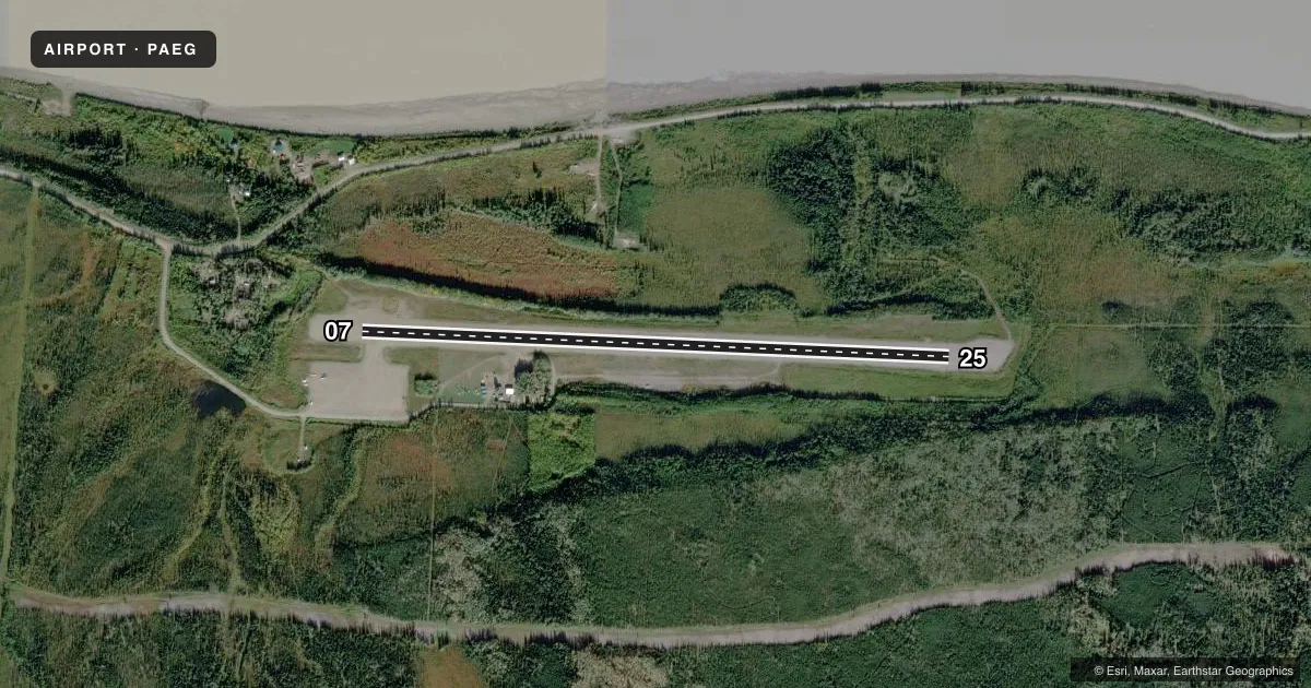
Runways & pattern
Full pagePattern entry · RWY 07
LEFT TRAFFICRunway end performance
| End | TORA | TODA | ASDA | LDA | VGSI | Approach lights | Obstruction |
|---|---|---|---|---|---|---|---|
| 07 | — | — | — | — | VASI 4-box left(3.75°) | — | 4', hill, 0' from thr, 110' R of cntrln, slope 1 |
| 25 | — | — | — | — | — | — | 90', trees, 1239' from thr, 218' R of cntrln, slope 13 |
Declared distances in feet. TORA = takeoff run available, TODA = takeoff distance, ASDA = accelerate-stop, LDA = landing distance.
Airport sketch
Runways drawn to scale from FAA survey coordinates, rendered over satellite imagery. Not for navigation.
Approaches & charts
Services on the field
Fuel grades, oxygen, maintenance, ramp storage and lighting — as declared to the FAA by the airport operator.
Fuel & services
- Fuel
- Not available
- Oxygen (bottled)
- Not available
- Oxygen (bulk)
- Not available
- Airframe repair
- Not available
- Power plant repair
- Not available
Ramp & ground
- Transient storage
- Tie-down
- Landing fee
- No fee published
- Customs
- Not available
- Lighting schedule
- SEE RMK
- Beacon schedule
- SEE RMK
- Beacon
- White / Green (civil land)(WG)
- Wind indicator
- Lighted
- Segmented circle
- Yes
Fuel & FBOs
Cheapest 100LL and Jet A on the field and nearby. Always confirm with the FBO before taxi.
Airport notes
Surface conditions, obstructions, local procedures, lighting outages and other notes published with each FAA cycle.
General notes
- RY CONDITION NOT MONITORED; RECOMMEND VISUAL INSPECTION PRIOR TO LANDING.
- SUAIS - 125.3/126.3(1-800-758-8723).
- WX CAMERA AVBL ON INTERNET AT HTTPS://WEATHERCAMS.FAA.GOV
- HEL OPN FR SOUTH RAMP DURG SUMMER MONTHS.
- 100LL AND JET A FUEL AVBL BY CALLING 907-547-2220.
- COLD TEMPERATURE AIRPORT. ALTITUDE CORRECTION REQUIRED AT OR BELOW -12C.
Lighting notes
- ACTVT ROTG BCN - CTAF.
- ACTVT MIRL RY 07/25 & VASI RY 07 - CTAF.
Approach & departure obstructions
- 07RYS 07 & 25 MKD WITH REFLECTIVE THLD PANELS & CONES.
Other notes
- CUSTOMS UNAVBL CONTACT 907-774-2252 FOR INFO.
VFR map & nearby airports
VFR sectional. Tap any ICAO chip to open that airport.
Key facts · PAEG
Answer card- ICAO
- PAEG
- Name
- EAGLE
- Location
- EAGLE, ALASKA
- Elevation
- 907.2 ft MSL
- Traffic pattern altitude
- 1,907.2 ft MSL (1,000 AGL)
- Control tower
- Non-towered (use CTAF)
- Total runways
- 1
- Longest runway
- 07/25 · 3,600 ft
- Published ILS approaches
- 0
- Published frequencies
- 2
- Magnetic variation
- 21°
- Current flight rules
- VFR
- Current wind
- 000° at 0 kt
- Favored runway now
- –
Eagle Airport (PAEG) sits in Eagle, Alaska. The field elevation is 907.2 ft MSL. It has one runway, 07/25, which is 3,600 ft long and gravel. There is no control tower. CTAF and UNICOM are both 122.8. No ILS approaches are published here.
Pattern altitude is not published. Use standard 1,000 ft AGL for light piston operations unless local guidance says otherwise. The runway headings in the published data are magnetic. Runway 07/25 uses medium intensity lights. The visual approach slope indicator on runway 07 is activated by CTAF. The rotating beacon is also controlled by CTAF. Runways 07 and 25 have reflective threshold panels and cones, so expect a simple but clearly marked strip.
No on-field FBOs are listed. Published remarks say 100LL and Jet A are available by calling the airport number. Customs is unavailable. The field is a cold temperature airport, so altitude correction is required at or below minus 12 degrees Celsius. Runway condition is not monitored, so a visual inspection before landing is a smart move. This is a gravel strip in a remote part of Alaska. Plan for winter performance. Plan for surface checks. Plan for the lack of published precision approach support before you go.