METAR & TAF PATA
Current METAR
Observed 02:52Z
PATA 270252Z 17004KT 10SM FEW080 BKN200 25/13 A2970 RMK AO2 TSE30 SLP057 T02500133 58005
- Wind
- 170° @ 4 kt
- Visibility
- 10 SM
- Temp / Dew
- 25°C / 13°C
- Altimeter
- 29.70 inHg
- Clouds
- BKN
- Density alt
- 1,773 ft
- Ceiling
- 20,000 ft AGL
- Rules
- VFR
Airport info & contacts
Manager on record, flight service, ARTCC, attendance schedule and pattern altitude — published by the FAA and refreshed every 28 days.
Location
- From city
- 1 NM WNW
- VFR sectional
- FAIRBANKS
- ARTCC
- ZAN · ANCHORAGE
- NOTAM facility
- TAL (NOTAM-D)
Airport manager
- Name
- JASON LUDINGTON
- Phone
- 907-451-5280
- Address
- 2301 PEGER ROAD, FAIRBANKS AK 99709
Flight service · Hours
- FSS FAI
- FAIRBANKS907-474-07881-866-248-6516
- Attendance
- Unattended
Frequencies
Tap any row to copy the frequency to your clipboard.
Runways & pattern
Full pagePattern entry · RWY 07
RIGHT TRAFFICRunway end performance
| End | TORA | TODA | ASDA | LDA | VGSI | Approach lights | Obstruction |
|---|---|---|---|---|---|---|---|
| 07 | — | — | — | — | VASI 4-box left(3°) | — | 2', brush, 0' from thr, 190' R of cntrln, slope 0 |
| 25 | — | — | — | — | — | — | 12', brush, 0' from thr, 180' R of cntrln, slope 0 |
Declared distances in feet. TORA = takeoff run available, TODA = takeoff distance, ASDA = accelerate-stop, LDA = landing distance.
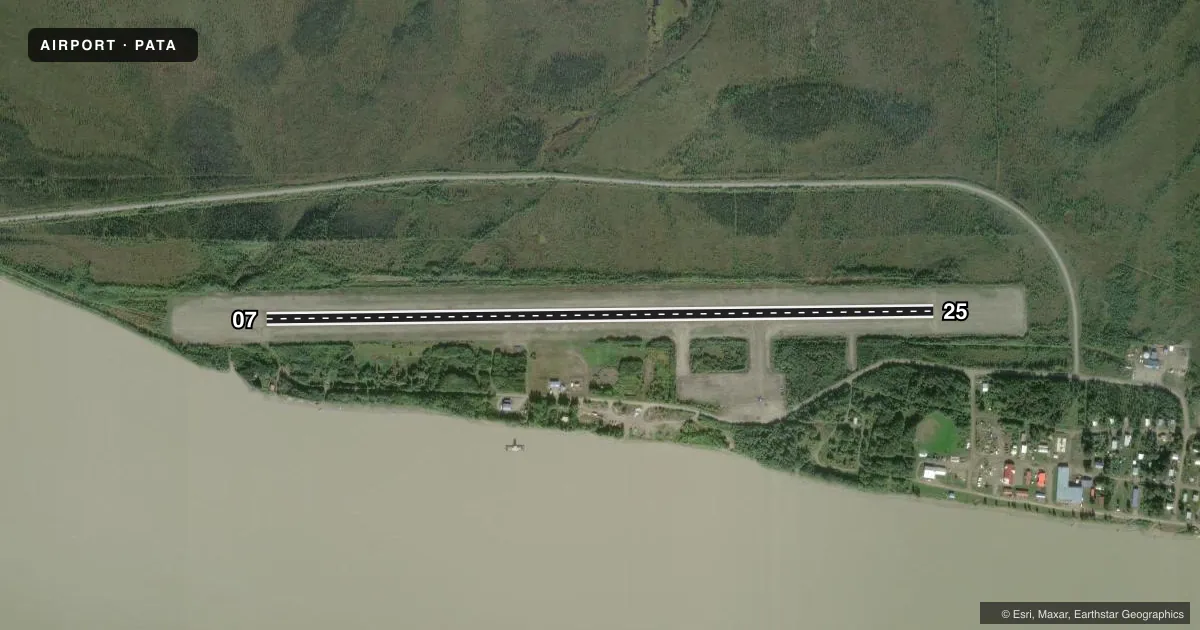
Airport sketch
Runways drawn to scale from FAA survey coordinates, rendered over satellite imagery. Not for navigation.
Approaches & charts
Services on the field
Fuel grades, oxygen, maintenance, ramp storage and lighting — as declared to the FAA by the airport operator.
Fuel & services
- Fuel
- Not available
- Other services
- CARGO
Ramp & ground
- Transient storage
- Tie-down
- Landing fee
- No fee published
- Customs
- Not available
- Lighting schedule
- SEE RMK
- Beacon schedule
- SS-SR
- Beacon
- White / Green (civil land)(WG)
- Wind indicator
- Lighted
- Segmented circle
- Yes
Fuel & FBOs
Cheapest 100LL and Jet A on the field and nearby. Always confirm with the FBO before taxi.
Airport notes
Surface conditions, obstructions, local procedures, lighting outages and other notes published with each FAA cycle.
General notes
- SNOW REMOVAL OPS - CTAF.
- RWY COND UNMNT; RCMD VISUAL INSP BFR USE.
- ADJ RIVER FLOATPLANE TFC.
- LCL TANANA WX OBS 0600-2130 - CTAF OR 907-366-7288.
- WX CAMERA AVBL ON INTERNET AT HTTPS://WEATHERCAMS.FAA.GOV
- TWY B UNLIT; 36 IN REFLECTORS; CLSD IN WINTER.
Lighting notes
- ACTVT VASI RWY 07; MIRL RWY 07/25 - CTAF.
VFR map & nearby airports
VFR sectional. Tap any ICAO chip to open that airport.
Key facts · PATA
Answer card- ICAO
- PATA
- Name
- RALPH M CALHOUN MEML
- Location
- TANANA, ALASKA
- Elevation
- 242.3 ft MSL
- Traffic pattern altitude
- 1,242.3 ft MSL (1,000 AGL)
- Control tower
- Non-towered (use CTAF)
- Total runways
- 1
- Longest runway
- 07/25 · 4,400 ft
- Published ILS approaches
- 0
- Published frequencies
- 1
- Magnetic variation
- 19°
- Current flight rules
- VFR
- Current wind
- 170° at 4 kt
- Favored runway now
- RWY 07
Ralph M Calhoun Meml Airport sits in Tanana, Alaska. Field elevation is 242.3 ft MSL. The airport has one runway. Runway 07/25 is 4,400 ft of gravel. There is no control tower. CTAF is 122.9. No ILS approaches are published here.
Pattern altitude is not published. Use 1,000 ft AGL for light piston operations unless local procedures or current airport information say otherwise. The field uses magnetic variation of 19°. Runway lighting for 07 and 25 is activated by CTAF. A visual approach slope indicator is also available for runway 07. Snow removal operations are conducted. Monitor CTAF closely. Runway condition is unmonitored, so a visual inspection before use is a smart call.
There are no on-field FBOs listed. Plan to confirm services before arrival. Adjacent river floatplane traffic is part of the picture here, so keep your scan outside the runway environment. Taxiway B is unlit with 36 inch reflectors. It is closed in winter. Local weather observations are available from 0600 to 2130 on CTAF or by calling the airport number in the Chart Supplement. A weather camera is also available online for a current look at the field.