METAR & TAF PAKX
Current METAR
Observed 08:15Z
PAKX 280815Z AUTO 00000KT 10SM BKN027 OVC065 10/10 A3005 RMK AO2
- Wind
- 000° @ 0 kt
- Visibility
- 10 SM
- Temp / Dew
- 10°C / 10°C
- Altimeter
- 30.05 inHg
- Clouds
- OVC
- Density alt
- -404 ft
- Ceiling
- 2,700 ft AGL
- Rules
- MVFR
Airport info & contacts
Manager on record, flight service, ARTCC, attendance schedule and pattern altitude — published by the FAA and refreshed every 28 days.
Location
- From city
- 0 NM N
- VFR sectional
- MC GRATH
- ARTCC
- ZAN · ANCHORAGE
- NOTAM facility
- 05K
Airport manager
- Name
- DAVID WILDER
- Phone
- 907-351-0493
- Address
- 3323 DRY CREEK, PORT ALSWORTH AK 99653
Flight service · Hours
- FSS ENA
- KENAI907-283-72111-866-864-1737
- Attendance
- Unattended
Frequencies
Tap any row to copy the frequency to your clipboard.
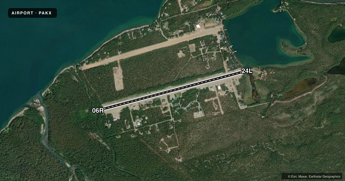
Runways & pattern
Full pagePattern entry · RWY 06R
RIGHT TRAFFICRunway end performance
| End | TORA | TODA | ASDA | LDA | VGSI | Approach lights | Obstruction |
|---|---|---|---|---|---|---|---|
| 06R | — | — | — | — | — | — | 25', trees, 0' from thr, 51' R of cntrln, slope 0 |
| 24L | — | — | — | — | — | — | 41', trees, 0' from thr, 122' R of cntrln, slope 0 |
Declared distances in feet. TORA = takeoff run available, TODA = takeoff distance, ASDA = accelerate-stop, LDA = landing distance.
Airport sketch
Runways drawn to scale from FAA survey coordinates, rendered over satellite imagery. Not for navigation.
Approaches & charts
Services on the field
Fuel grades, oxygen, maintenance, ramp storage and lighting — as declared to the FAA by the airport operator.
Fuel & services
- Fuel
- 100LLA
Ramp & ground
- Transient storage
- Not published
- Wind indicator
- Yes
- Segmented circle
- No
Fuel & FBOs
Cheapest 100LL and Jet A on the field and nearby. Always confirm with the FBO before taxi.
Airport notes
Surface conditions, obstructions, local procedures, lighting outages and other notes published with each FAA cycle.
General notes
- RWY UNATNDD - RCMDD VISUAL INSP PRIOR TO LNDG.
- MINIMAL WINTER MAINT.
- LAKE CLARK WX CAMERAS AVBL ON INTERNET AT HTTPS://WEATHERCAMS.FAA.GOV
- 3000 FT DIRT-GRVL RWY SEPARATE OWNED & OPR 1/4 MI N & PARL TO RWY 06R/24L.
- ALL OPS MNT CTAF.
- COLD TEMPERATURE AIRPORT. ALTITUDE CORRECTION REQUIRED AT OR BELOW -18C.
Runway surface & condition
- 06R/24LSOFT DURG SPRING.
Approach & departure obstructions
- 24LVEHICLE TFC XS APCH END OF RWY 24L; NOT VSB FM OTR END.
- 06RREFLECTIVE CONES OUTLINE ONE SIDE; ENDS UNMKD.
Other notes
- MANAGERDAVE WILDER - 907-351-0493
- 06R/24LGRAVEL-DIRT.
VFR map & nearby airports
VFR sectional. Tap any ICAO chip to open that airport.
Key facts · PAKX
Answer card- ICAO
- PAKX
- Name
- WILDER RUNWAY
- Location
- PORT ALSWORTH, ALASKA
- Elevation
- 288 ft MSL
- Traffic pattern altitude
- 1,288 ft MSL (1,000 AGL)
- Control tower
- Non-towered (use CTAF)
- Total runways
- 1
- Longest runway
- 06R/24L · 3,849 ft
- Published ILS approaches
- 0
- Published frequencies
- 1
- Magnetic variation
- 13°
- Current flight rules
- MVFR
- Current wind
- 000° at 0 kt
- Favored runway now
- –
Wilder Runway sits at Port Alsworth, Alaska. Field elevation is 288 ft MSL. The airport has one runway, 06R/24L, which is 3,849 ft long and surfaced with gravel and dirt. There is no control tower. All operations use CTAF 122.9. No ILS approaches are published here. Pattern altitude is not published, so use standard 1,000 ft AGL for light piston operations unless the current Chart Supplement says otherwise.
This is a cold-temperature airport. Altitude correction is required at or below minus 18 degrees Celsius. The runway is unattended, so a visual inspection before landing is a good habit. Published remarks also say runway 06R/24L can be soft in spring. Reflective cones outline one side of runway 06R. The runway ends are unmarked. Vehicle traffic crosses the approach end of runway 24L. That crossing is not visible from the opposite end.
No on-field FBOs are listed. Check with the airport operator or call the field directly before arrival if you need services. A separate 3,000-foot dirt and gravel runway is owned and operated one quarter mile north and parallel to 06R/24L. For current weather camera views, Lake Clark weather cameras are available online. For any current operational notes, verify the latest Chart Supplement before you go.