METAR & TAF PAIL
Current METAR
Observed 10:53Z
PAIL 281053Z 24007KT 10SM -RA BKN043 OVC060 08/07 A3012 RMK AO2 SLP202 P0000 T00830072
- Wind
- 240° @ 7 kt
- Visibility
- 10 SM
- Temp / Dew
- 8°C / 7°C
- Altimeter
- 30.12 inHg
- Clouds
- OVC
- Density alt
- -849 ft
- Ceiling
- 4,300 ft AGL
- Rules
- VFR
Airport info & contacts
Manager on record, flight service, ARTCC, attendance schedule and pattern altitude — published by the FAA and refreshed every 28 days.
Location
- From city
- 2 NM NW
- VFR sectional
- KODIAK
- ARTCC
- ZAN · ANCHORAGE
- NOTAM facility
- ILI (NOTAM-D)
Airport manager
- Name
- TREFIM ANDREW
- Phone
- 907-571-1261
- Address
- BOX 187, ILIAMNA AK 99606
Flight service · Hours
- FSS ILI
- ILIAMNA907-571-1240LC571-1240
- Attendance
- OCT-MAY · M-F · 0800-1630
- JUN-SEP · M-W · 0600-1630
- JUNE-SEP · TH · 0600-1400
Frequencies
Tap any row to copy the frequency to your clipboard.
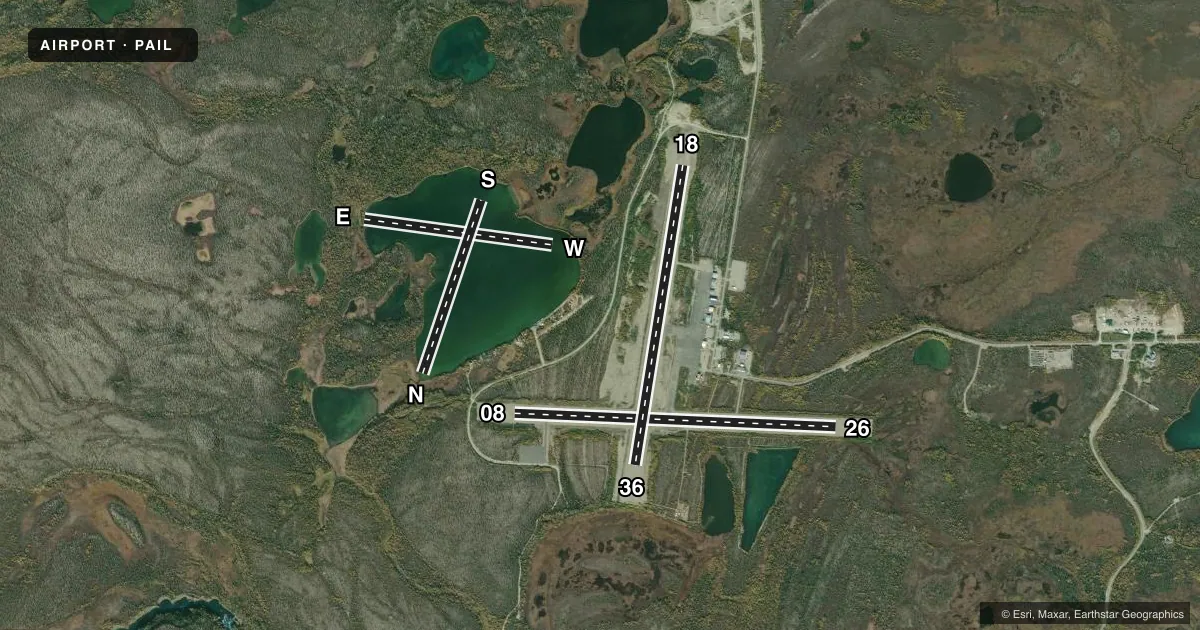
Runways & pattern
Full pagePattern entry · RWY 26
LEFT TRAFFIC| Runway | Heading (°M) | Length | Surface | Traffic |
|---|---|---|---|---|
| 08/26Favored | 78° / 258° | 5,086 ft | ASPH | Standard L |
| 18/36 | 175° / 355° | 4,800 ft | ASPH | Standard L |
| E/W | 84° / 264° | 2,998 ft | WATER | Standard L |
| N/S | 5° / 185° | 2,892 ft | WATER | S R |
Runway end performance
| End | TORA | TODA | ASDA | LDA | VGSI | Approach lights | Obstruction |
|---|---|---|---|---|---|---|---|
| 08 | — | — | — | — | PAPI 4-box left(3°) | — | 10', brush, 200' from thr, 215' R of cntrln, slope 0 |
| 26 | — | — | — | — | PAPI 4-box left(3°) | — | 12', brush, 200' from thr, 187' R of cntrln, slope 0 |
| 18 | — | — | — | — | PAPI 4-box left(3°) | — | 12', brush, 200' from thr, 195' R of cntrln, slope 0 |
| 36 | — | — | — | — | PAPI 4-box left(3°) | — | 4', brush, 200' from thr, 165' R of cntrln, slope 0 |
Declared distances in feet. TORA = takeoff run available, TODA = takeoff distance, ASDA = accelerate-stop, LDA = landing distance.
Airport sketch
Runways drawn to scale from FAA survey coordinates, rendered over satellite imagery. Not for navigation.
Approaches & charts
Services on the field
Fuel grades, oxygen, maintenance, ramp storage and lighting — as declared to the FAA by the airport operator.
Fuel & services
- Fuel
- 100LLA
Ramp & ground
- Transient storage
- Tie-down
- Customs
- Not available
- Lighting schedule
- SEE RMK
- Beacon
- White / Green (civil land)(WG)
- Wind indicator
- Yes
- Segmented circle
- Yes
Fuel & FBOs
Cheapest 100LL and Jet A on the field and nearby. Always confirm with the FBO before taxi.
Airport notes
Surface conditions, obstructions, local procedures, lighting outages and other notes published with each FAA cycle.
General notes
- SNOW & ICE REMOVAL & HAZ RPRTNG DURG DUTY HR; EXC PPR IN WRITING - AMGR.
- TAXI ON ACTIVE RWYS; LOCKED BRAKE TURNS ON RWYS NA.
- PSNL & EQPT MAY BE ON RWY.
- SAFETY AREAS SOFT.
- MULT AIRSTRIPS & FLOAT PLANE BASINS INVOF ARPT; LOW-LEVEL HEL SLING LOAD OPS WI 25 NM W-NW; MNT CTAF & SELF ANNOUNCE UPON ENTRY.
- BE ALERT: NO LINE OF SIGHT BTN ILIAMNA, PIKE LAKE & EAST WIND LAKE/STRIP; TFC PAT & VFR ARR & DEP PROC SEE SECTION C NOTICE.
- TSNT PRKG MKD WITH GREEN CONES.
- WX CAMERAS AVBL ON INTERNET AT HTTPS://WEATHERCAMS.FAA.GOV/.
- ARPT SAND LRGR THAN FAA RCMDD/SEE AC150/5200-30.
- WX OBS 16 OCT-14 MAY 0545-2145 - ILIAMNA WX 133.75 OR 907-571-1240.
- COLD TEMPERATURE AIRPORT. ALTITUDE CORRECTION REQUIRED AT OR BELOW -26C.
Lighting notes
- WHEN FSS CLSD ACTVT REIL RWY 26 & 36; PAPI RWY 18, 36, 08, & 26; MIRL RWY 08/26; 18/36 - CTAF.
Runway surface & condition
- 08/26TUNDRA WHEEL GRVL SFC 275 FT PRIOR TO ASPH BOTH END; DALGT OPS ONLY.
VFR map & nearby airports
VFR sectional. Tap any ICAO chip to open that airport.
Key facts · PAIL
Answer card- ICAO
- PAIL
- Name
- ILIAMNA
- Location
- ILIAMNA, ALASKA
- Elevation
- 192.4 ft MSL
- Traffic pattern altitude
- 1,192.4 ft MSL (1,000 AGL)
- Control tower
- Non-towered (use CTAF)
- Total runways
- 4
- Longest runway
- 08/26 · 5,086 ft
- Published ILS approaches
- 0
- Published frequencies
- 1
- Magnetic variation
- 14°
- Current flight rules
- VFR
- Current wind
- 240° at 7 kt
- Favored runway now
- RWY 26
Iliamna Airport sits in Iliamna, Alaska. Field elevation is 192.4 ft MSL. The airport has four runways. The longest is 5,086 ft on runway 08/26. There is no control tower. CTAF is 123.6. No ILS approaches are published.
Pattern altitude is not published. Use standard 1,000 ft AGL for light piston traffic unless the current FAA Chart Supplement says otherwise. Iliamna Airport Fuel Operations is on the field. It carries 100LL and Jet A. Call (907) 830-1057 for current service status before you go.
This field has several operational points that matter on arrival. There is no line of sight between Iliamna, Pike Lake and East Wind Lake or strip. Self-announce on CTAF and stay alert for other traffic. Multiple airstrips and float plane basins are nearby. Low-level helicopter sling load work can occur within 25 NM west to northwest. Taxi on active runways. Locked brake turns are not authorized. Runway 08/26 has a 275 ft gravel section before the asphalt on both ends. Daylight operations only apply there. This is also a cold temperature airport. Altitude correction is required at or below minus 26 C. Weather observations are available seasonally, so check current conditions before departure.