METAR & TAF PAKL
PAKL does not publish a METAR.
Showing the nearest reporting station: PAIG (IGIUGIG) · 32.9 NM away. Conditions at PAKL may differ.
METAR · PAIG
Observed 03:56Z
PAIG 280356Z AUTO 18015G24KT 10SM CLR 14/08 A3004 RMK AO2 SLP180 T01440078
- Wind
- 180° @ 15G24 kt
- Visibility
- 10 SM
- Temp / Dew
- 14°C / 8°C
- Altimeter
- 30.04 inHg
- Clouds
- CLR
- Density alt
- 620 ft
- Ceiling
- Unlimited
- Rules
- VFR
Airport info & contacts
Manager on record, flight service, ARTCC, attendance schedule and pattern altitude — published by the FAA and refreshed every 28 days.
Location
- From city
- 1 NM S
- VFR sectional
- KODIAK
- ARTCC
- ZAN · ANCHORAGE
- NOTAM facility
- ILI (NOTAM-D)
Airport manager
- Name
- PUBLIC PARK SUPT.
- Phone
- 907-246-3305
- Address
- P.O. BOX 7, KING SALMON AK 99613
Flight service · Hours
- FSS ILI
- ILIAMNA907-571-1240LC571-1240
- Attendance
- Unattended
Frequencies
Tap any row to copy the frequency to your clipboard.
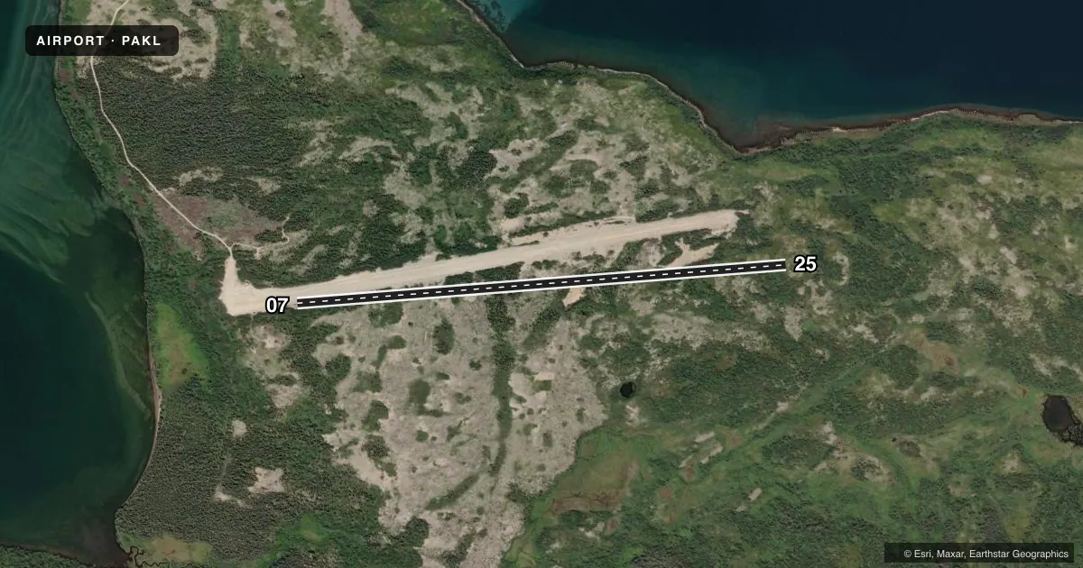
Runways & pattern
Full pagePattern entry · RWY 25
LEFT TRAFFICRunway end performance
| End | TORA | TODA | ASDA | LDA | VGSI | Approach lights | Obstruction |
|---|---|---|---|---|---|---|---|
| 07 | — | — | — | — | — | — | 15', brush, 0' from thr, slope 0 |
| 25 | — | — | — | — | — | — | 15', brush, 0' from thr, slope 0 |
Declared distances in feet. TORA = takeoff run available, TODA = takeoff distance, ASDA = accelerate-stop, LDA = landing distance.
Airport sketch
Runways drawn to scale from FAA survey coordinates, rendered over satellite imagery. Not for navigation.
Approaches & charts
Services on the field
Fuel grades, oxygen, maintenance, ramp storage and lighting — as declared to the FAA by the airport operator.
Fuel & services
- Fuel
- Not available
- Oxygen (bottled)
- Not available
- Oxygen (bulk)
- Not available
- Airframe repair
- Not available
- Power plant repair
- Not available
Ramp & ground
- Transient storage
- Not published
- Landing fee
- Yes
- Customs
- Not available
- Wind indicator
- No
- Segmented circle
- No
Fuel & FBOs
Cheapest 100LL and Jet A on the field and nearby. Always confirm with the FBO before taxi.
Airport notes
Surface conditions, obstructions, local procedures, lighting outages and other notes published with each FAA cycle.
General notes
- RY 18W/36W ACTIVE SUMMER FISHING SEASON ONLY - PUBLIC USE.
- USE EXTREME CTN IN HIGH & GUSTY WIND.
- RAMP ON W END OF RY PRIVATELY OWNED. YELLOW BARRELS MARK PROPERTY LINE.
- EAST 2000 FEET OF RY ON NATL PARK LAND & OPEN TO THE PUBLIC; WEST 2600 FEET OF RY ON PVT LAND & CLSD TO THE PUBLIC - CTC RAYMOND PETERSON-4700 AIRCRAFT DR; ANCHORAGE AK 99502 OR CALL 907-243-5448.
- HVY BEAR CONCENTRATION; BEARS FREQUENTLY ON RY DURING SUMMER.
- SEAPLANE BASE IS PVT PROPERTY, NO SVCS OR FACS AVBL.
Other notes
- 07/25SFC COVERED UNIFORMLY WITH LOOSE 2 TO 5 INCH STONES.
VFR map & nearby airports
VFR sectional. Tap any ICAO chip to open that airport.
Key facts · PAKL
Answer card- ICAO
- PAKL
- Name
- KULIK LAKE
- Location
- KULIK LAKE, ALASKA
- Elevation
- 717 ft MSL
- Traffic pattern altitude
- 1,717 ft MSL (1,000 AGL)
- Control tower
- Non-towered (use CTAF)
- Total runways
- 1
- Longest runway
- 07/25 · 4,400 ft
- Published ILS approaches
- 0
- Published frequencies
- 1
- Magnetic variation
- 15°
- Current flight rules
- VFR
- Current wind
- 180° at 15 kt
- Favored runway now
- RWY 25
Kulik Lake Airport (PAKL) sits at Kulik Lake in Alaska. Field elevation is 717 ft MSL. The airport has one runway. Runway 07/25 is 4,400 ft long with a gravel-dirt surface. The published runway headings are magnetic 86°/266°. There is no control tower. CTAF is 122.9.
No ILS approaches are published here. Pattern altitude is not published, so verify the current Chart Supplement before you go. For light piston planning, use the standard 1,000 ft AGL pattern unless local guidance says otherwise. The field sits in a remote part of Alaska, so weather, wind and surface condition matter a lot more than they do at a paved lower-48 strip. The published remarks call for extreme caution in high and gusty wind. They also note loose 2 to 5 inch stones on the runway surface. That is worth factoring into tire, prop and braking planning.
There is no on-field FBO listed. Check with the airport operator or the FBO directly by phone before arrival if you need current services. The remarks also note heavy bear activity on the runway during summer. The east 2,000 feet is on national park land and open to the public. The west 2,600 feet is on private land and closed to the public. The west-end ramp is privately owned. Yellow barrels mark the property line.