METAR & TAF PAAI
PAAI does not publish a METAR.
Showing the nearest reporting station: PANW (NEW STUYAHOK) · 25.0 NM away. Conditions at PAAI may differ.
METAR · PANW
Observed 04:56Z
PANW 280456Z AUTO 22016KT 10SM CLR 14/07 A3003 RMK AO2 SLP174 T01390067 $
- Wind
- 220° @ 16 kt
- Visibility
- 10 SM
- Temp / Dew
- 14°C / 7°C
- Altimeter
- 30.03 inHg
- Clouds
- CLR
- Density alt
- -187 ft
- Ceiling
- Unlimited
- Rules
- VFR
Airport info & contacts
Manager on record, flight service, ARTCC, attendance schedule and pattern altitude — published by the FAA and refreshed every 28 days.
Location
- From city
- 1 NM NNW
- VFR sectional
- KODIAK
- ARTCC
- ZAN · ANCHORAGE
- NOTAM facility
- ENA (NOTAM-D)
Airport manager
- Name
- FLOYD WILSON
- Phone
- 907-246-3325
- Address
- P. O. BOX 65, KING SALMON AK 99613
Flight service · Hours
- FSS ENA
- KENAI907-283-72111-866-864-1737
- Attendance
- Unattended
Frequencies
Tap any row to copy the frequency to your clipboard.
Runways & pattern
Full pagePattern entry · RWY 19
LEFT TRAFFICRunway end performance
| End | TORA | TODA | ASDA | LDA | VGSI | Approach lights | Obstruction |
|---|---|---|---|---|---|---|---|
| 01 | — | — | — | — | — | — | 5', brush, 5' from thr, 96' R of cntrln, slope 1 |
| 19 | — | — | — | — | — | — | 6', brush, 70' from thr, 170' R of cntrln, slope 11 |
Declared distances in feet. TORA = takeoff run available, TODA = takeoff distance, ASDA = accelerate-stop, LDA = landing distance.
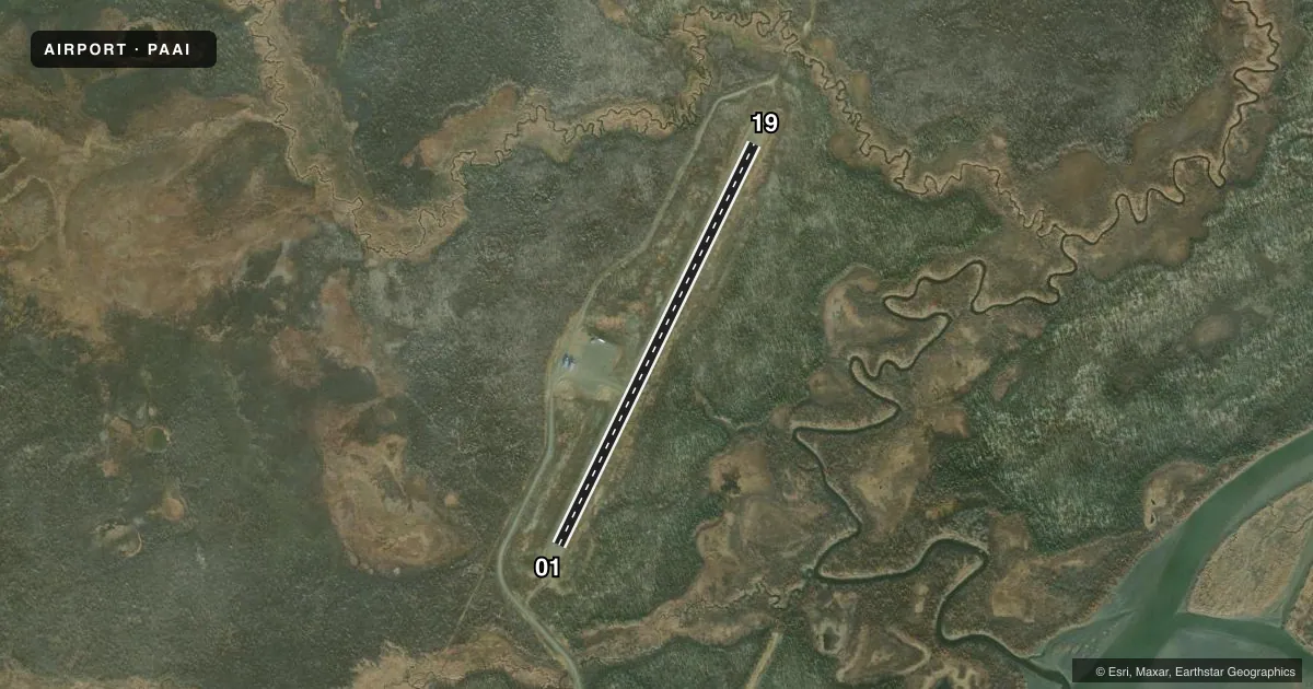
Airport sketch
Runways drawn to scale from FAA survey coordinates, rendered over satellite imagery. Not for navigation.
Approaches & charts
Services on the field
Fuel grades, oxygen, maintenance, ramp storage and lighting — as declared to the FAA by the airport operator.
Fuel & services
- Fuel
- Not available
Ramp & ground
- Transient storage
- Tie-down
- Lighting schedule
- SEE RMK
- Beacon schedule
- SEE RMK
- Beacon
- White / Green (civil land)(WG)
- Wind indicator
- Lighted
- Segmented circle
- Yes
Fuel & FBOs
Cheapest 100LL and Jet A on the field and nearby. Always confirm with the FBO before taxi.
Airport notes
Surface conditions, obstructions, local procedures, lighting outages and other notes published with each FAA cycle.
General notes
- RWY COND UNMNT; RCMD VISUAL INSP BFR LNDG.
- SAFETY AREA BYD THRS SOFT SINKING SAND; USE ONLY AS EMERG OVRN.
Lighting notes
- ACTVT ROTG BCN - CTAF.
- ACTVT MIRL RWY 01/19 - CTAF.
Other notes
- PRVDD THAT PROPOSED ARPT DEVELOPMENT THAT REQUIRES ENVIRONMENTAL PROCESSING SHALL NOT BE UNDERTAKEN WITHOUT PRIOR WRITTEN ENVIRONMENTAL APPROVAL BY THE FAA.
- MAY BE UNRELBL.
- 01/19SFC & SHOULDERS SOFT & MUDDY WHEN WET. MULT 2-4 IN RUTS ON EDGES & CRC RUTS NEAR THRS.
VFR map & nearby airports
VFR sectional. Tap any ICAO chip to open that airport.
Key facts · PAAI
Answer card- ICAO
- PAAI
- Name
- LEVELOCK
- Location
- LEVELOCK, ALASKA
- Elevation
- 55.8 ft MSL
- Traffic pattern altitude
- 1,055.8 ft MSL (1,000 AGL)
- Control tower
- Non-towered (use CTAF)
- Total runways
- 1
- Longest runway
- 01/19 · 3,284 ft
- Published ILS approaches
- 0
- Published frequencies
- 2
- Magnetic variation
- 18°
- Current flight rules
- VFR
- Current wind
- 220° at 16 kt
- Favored runway now
- RWY 19
Lewelock Airport is in Lewelock, Alaska. The field elevation is 55.8 ft MSL. It has one runway, 01/19, which is 3,284 ft long and surfaced with gravel and dirt. There is no control tower. CTAF is 122.9. UNICOM is 122.95.
No ILS approaches are published here. Pattern altitude is not published, so use the standard 1,000 ft AGL for light piston operations unless the current FAA Chart Supplement says otherwise. The airport sits in a low coastal Alaska setting, so expect weather and surface conditions to matter more than at a paved field. The runway condition is unmonitored. A visual inspection before landing is a good call. Published remarks also say the runway surface and shoulders can be soft and muddy when wet. There are multiple ruts near the edges and cracked ruts near the thresholds. The safety area beyond the thresholds is soft sinking sand. Treat that area as an emergency overrun only.
There are no on-field FBOs listed. The rotating beacon and the medium intensity runway lights for 01/19 are activated by the CTAF. The wind indicator may be unreliable, so do not rely on it alone for the landing decision. Check the current FAA Chart Supplement for any local operating notes before you go.