METAR & TAF 5NK
5NK does not publish a METAR.
Showing the nearest reporting station: PFWS (SOUTH NAKNEK NR 2) · 2.1 NM away. Conditions at 5NK may differ.
METAR · PFWS
Observed 12:40Z
PFWS 281240Z AUTO 20006KT 10SM FEW009 OVC065 07/07 A3017 RMK AO2
- Wind
- 200° @ 6 kt
- Visibility
- 10 SM
- Temp / Dew
- 7°C / 7°C
- Altimeter
- 30.17 inHg
- Clouds
- OVC
- Density alt
- -1,183 ft
- Ceiling
- 6,500 ft AGL
- Rules
- VFR
Airport info & contacts
Manager on record, flight service, ARTCC, attendance schedule and pattern altitude — published by the FAA and refreshed every 28 days.
Location
- From city
- 1 NM N
- VFR sectional
- KODIAK
- ARTCC
- ZAN · ANCHORAGE
- NOTAM facility
- ENA (NOTAM-D)
Airport manager
- Name
- FLOYD WILSON
- Phone
- 907-246-3325
- Address
- BOX 65, KING SALMON AK 99613
Flight service · Hours
- FSS ENA
- KENAI907-283-72111-866-864-1737
- Attendance
- Unattended
Frequencies
Tap any row to copy the frequency to your clipboard.
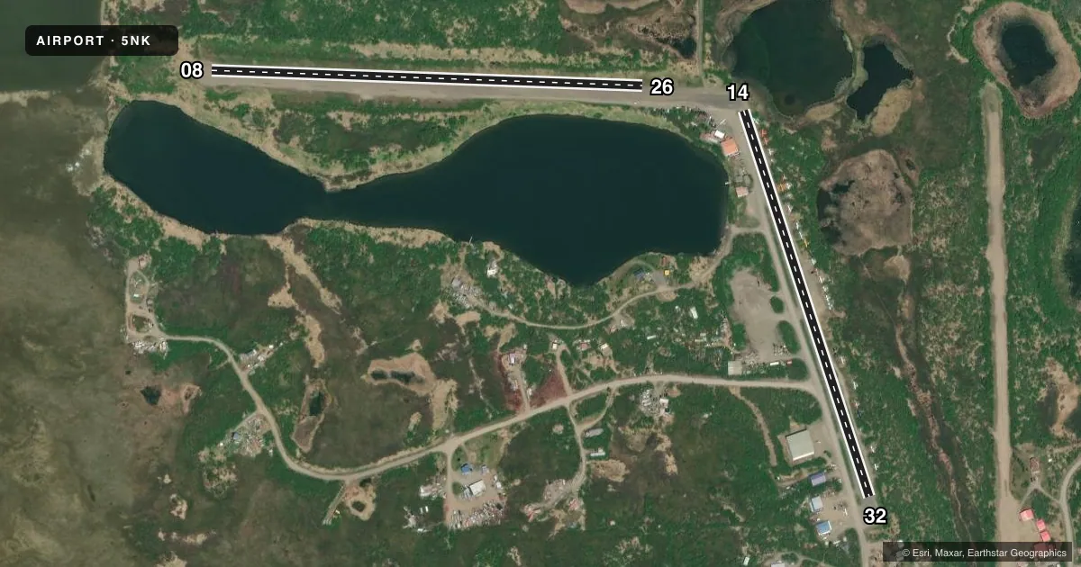
Runways & pattern
Full pagePattern entry · RWY 14
LEFT TRAFFIC| Runway | Heading (°M) | Length | Surface | Traffic |
|---|---|---|---|---|
| 08/26 | 71° / 251° | 1,950 ft | GRAVEL | Standard L |
| 14/32Favored | 141° / 321° | 1,836 ft | GRAVEL | Standard L |
Runway end performance
| End | TORA | TODA | ASDA | LDA | VGSI | Approach lights | Obstruction |
|---|---|---|---|---|---|---|---|
| 08 | — | — | — | — | — | — | 2', brush, 0' from thr, 110' R of cntrln, slope 0 |
| 26 | — | — | — | — | — | — | 15', brush, 0' from thr, 110' R of cntrln, slope 0 |
| 14 | — | — | — | — | — | — | 5', brush, 0' from thr, 57' R of cntrln, slope 0 |
| 32 | — | — | — | — | — | — | 5', brush, 0' from thr, 56' R of cntrln, slope 0 |
Declared distances in feet. TORA = takeoff run available, TODA = takeoff distance, ASDA = accelerate-stop, LDA = landing distance.
Airport sketch
Runways drawn to scale from FAA survey coordinates, rendered over satellite imagery. Not for navigation.
Approaches & charts
Services on the field
Fuel grades, oxygen, maintenance, ramp storage and lighting — as declared to the FAA by the airport operator.
Fuel & services
- Fuel
- 100LL
- Oxygen (bottled)
- Not available
- Oxygen (bulk)
- Not available
- Airframe repair
- Major
- Power plant repair
- Minor
Ramp & ground
- Transient storage
- Tie-down
- Hangar
- Landing fee
- No fee published
- Customs
- Not available
- Wind indicator
- Yes
- Segmented circle
- No
Fuel & FBOs
Cheapest 100LL and Jet A on the field and nearby. Always confirm with the FBO before taxi.
Airport notes
Surface conditions, obstructions, local procedures, lighting outages and other notes published with each FAA cycle.
General notes
- SEAPLANES E APCH TO LAKE OVER RWY 14-32 & TIBBETTS ARPT.
- NO LINE OF SIGHT BETWEEN RUNWAYS OR WATERWAYS.
- FLOAT ACFT DEPARTING NORTHWEST LAKE TO EAST, CROSS ARPT AT LOW ALTITUDE, ACFT NOT VISIBLE UNTIL AIRBORNE.
- UNCONTROLLED VEHICULAR TFC ON RYS.
- RY COND NOT MONITORED; RECOMMEND VISUAL INSPECTION PRIOR TO USING.
- ACFT ON EAST SIDE OF RY 14/32 TIED DOWN IN SAFETY AREA.
- WX CAMERA AVBL ON INTERNET AT HTTPS://WEATHERCAMS.FAA.GOV
- AIRPORT UNLIT
Runway surface & condition
- 08W/26WRY 08W/26W SPB NOT ON ARPT PROPERTY & IS NOT OWNED OR OPERATED BY THE STATE OF ALASKA.
Other notes
- TRANSIENT PARKING ALONG SOUTH SIDE OF RY 08/26.
- WINDSOCK UNRELIABLE.
- 08/26ROCKS EXCEEDING 2 IN DIAM & RUTS 6 INCHES. RY 08 SLOPES DOWNHILL TO EAST.
- 14/32ROCKS EXCEEDING 2-3 IN DIAM AND 3 INCH RUTS. FIRST 200 FT RY 32 SOFT WHEN WET & FIRST 400 FT SLOPES DOWNHILL.
VFR map & nearby airports
VFR sectional. Tap any ICAO chip to open that airport.
Key facts · 5NK
Answer card- ICAO
- 5NK
- Name
- NAKNEK
- Location
- NAKNEK, ALASKA
- Elevation
- 70 ft MSL
- Traffic pattern altitude
- 1,070 ft MSL (1,000 AGL)
- Control tower
- Non-towered (use CTAF)
- Total runways
- 2
- Longest runway
- 08/26 · 1,950 ft
- Published ILS approaches
- 0
- Published frequencies
- 1
- Magnetic variation
- 21°
- Current flight rules
- VFR
- Current wind
- 200° at 6 kt
- Favored runway now
- RWY 14
Naknek Airport (5NK) is in Naknek, Alaska. Field elevation is 70 ft MSL. The airport has two gravel runways. The longest is runway 08/26 at 1,950 ft. There is no control tower. CTAF is 122.9.
No ILS approaches are published here. Pattern altitude is not published, so use standard 1,000 ft AGL for light piston operations unless the current Chart Supplement says otherwise. The field is uncontrolled, so expect self-announce traffic and keep a sharp scan. Published remarks also say runway condition is not monitored. A visual inspection is recommended before use. The airport is unlit. The windsock is unreliable. Uncontrolled vehicular traffic is present on the runways.
There are no on-field FBOs listed. Contact the airport operator directly before arrival if you need local services. Runway 08/26 has rocks exceeding 2 inches in diameter and ruts up to 6 inches deep. Runway 14/32 has rocks exceeding 2 to 3 inches in diameter and 3 inch ruts. The first 200 feet of runway 32 is soft when wet. The first 400 feet slopes downhill. There is no line of sight between runways or waterways. Seaplanes approach the lake from the east over runway 14-32 and Tibbets Airport. Float aircraft departing the northwest lake to the east cross the airport at low altitude. They are not visible until airborne.