METAR & TAF PAAV
PAAV does not publish a METAR.
Showing the nearest reporting station: PANW (NEW STUYAHOK) · 6.4 NM away. Conditions at PAAV may differ.
METAR · PANW
Observed 03:23Z
PANW 250323Z AUTO 19005KT 10SM -RA FEW021 BKN033 OVC048 11/09 A2997 RMK AO2 P0000 $
- Wind
- 190° @ 5 kt
- Visibility
- 10 SM
- Temp / Dew
- 11°C / 9°C
- Altimeter
- 29.97 inHg
- Clouds
- OVC
- Density alt
- -366 ft
- Ceiling
- 3,300 ft AGL
- Rules
- VFR
Airport info & contacts
Manager on record, flight service, ARTCC, attendance schedule and pattern altitude — published by the FAA and refreshed every 28 days.
Location
- From city
- 0 NM NNW
- VFR sectional
- KODIAK
- ARTCC
- ZAN · ANCHORAGE
- NOTAM facility
- DLG (NOTAM-D)
Airport manager
- Name
- KEVIN HARDIN
- Phone
- 907-842-5511
- Address
- BOX 250, DILLINGHAM AK 99576
Flight service · Hours
- FSS DLG
- DILLINGHAM907-842-5275LC842-5275
- Attendance
- Unattended
Frequencies
Tap any row to copy the frequency to your clipboard.
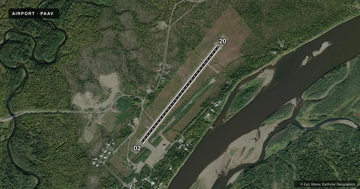
Runways & pattern
Full pagePattern entry · RWY 21
LEFT TRAFFICRunway end performance
| End | TORA | TODA | ASDA | LDA | VGSI | Approach lights | Obstruction |
|---|---|---|---|---|---|---|---|
| 03 | — | — | — | — | — | — | 8', brush, 0' from thr, 123' R of cntrln, slope 0 |
| 21 | — | — | — | — | — | — | 7', brush, 0' from thr, 124' R of cntrln, slope 0 |
Declared distances in feet. TORA = takeoff run available, TODA = takeoff distance, ASDA = accelerate-stop, LDA = landing distance.
Airport sketch
Runways drawn to scale from FAA survey coordinates, rendered over satellite imagery. Not for navigation.
Approaches & charts
Services on the field
Fuel grades, oxygen, maintenance, ramp storage and lighting — as declared to the FAA by the airport operator.
Fuel & services
- Fuel
- Not available
Ramp & ground
- Transient storage
- Tie-down
- Landing fee
- No fee published
- Customs
- Not available
- Lighting schedule
- SEE RMK
- Beacon schedule
- SEE RMK
- Beacon
- White / Green (civil land)(WG)
- Wind indicator
- Lighted
- Segmented circle
- Yes
Fuel & FBOs
Cheapest 100LL and Jet A on the field and nearby. Always confirm with the FBO before taxi.
Airport notes
Surface conditions, obstructions, local procedures, lighting outages and other notes published with each FAA cycle.
General notes
- CTN: VEHICLES X RWY.
- RWY COND UNMNT; RCMD VISUAL INSP BFR USE.
- WX CAMERA AVBL ON INTERNET AT HTTPS://WEATHERCAMS.FAA.GOV.
Lighting notes
- ACTVT ROTG BCN - CTAF.
- ACTVT MIRL RWY 03/21 - CTAF.
Approach & departure obstructions
- 03CTLG OBSTN EXCEEDS 45 DEG SLOPE.
VFR map & nearby airports
VFR sectional. Tap any ICAO chip to open that airport.
Key facts · PAAV
Answer card- ICAO
- PAAV
- Name
- EKWOK
- Location
- EKWOK, ALASKA
- Elevation
- 141.6 ft MSL
- Traffic pattern altitude
- 1,141.6 ft MSL (1,000 AGL)
- Control tower
- Non-towered (use CTAF)
- Total runways
- 1
- Longest runway
- 03/21 · 3,300 ft
- Published ILS approaches
- 0
- Published frequencies
- 1
- Magnetic variation
- –
- Current flight rules
- VFR
- Current wind
- 190° at 5 kt
- Favored runway now
- RWY 21