METAR & TAF PANW
Current METAR
Observed 10:56Z
PANW 281056Z AUTO 23015KT 10SM OVC002 07/06 A3012 RMK AO2 SLP204 T00670061 $
- Wind
- 230° @ 15 kt
- Visibility
- 10 SM
- Temp / Dew
- 7°C / 6°C
- Altimeter
- 30.12 inHg
- Clouds
- OVC
- Density alt
- -748 ft
- Ceiling
- 200 ft AGL
- Rules
- LIFR
Airport info & contacts
Manager on record, flight service, ARTCC, attendance schedule and pattern altitude — published by the FAA and refreshed every 28 days.
Location
- From city
- 1 NM W
- VFR sectional
- KODIAK
- ARTCC
- ZAN · ANCHORAGE
- NOTAM facility
- KNW (NOTAM-D)
Airport manager
- Name
- KEVIN HARDIN
- Phone
- 907-842-5511
- Address
- BOX 250, DILLINGHAM AK 99576
Flight service · Hours
- FSS DLG
- DILLINGHAM907-842-5275LC842-5275
- Attendance
- Unattended
Frequencies
Tap any row to copy the frequency to your clipboard.
Runways & pattern
Full pagePattern entry · RWY 14
LEFT TRAFFICRunway end performance
| End | TORA | TODA | ASDA | LDA | VGSI | Approach lights | Obstruction |
|---|---|---|---|---|---|---|---|
| 14 | — | — | — | — | PAPI 4-box left(3°) | — | — |
| 32 | — | — | — | — | PAPI 4-box left(3°) | — | — |
Declared distances in feet. TORA = takeoff run available, TODA = takeoff distance, ASDA = accelerate-stop, LDA = landing distance.
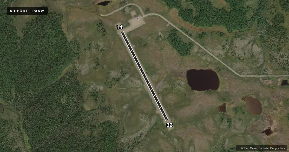
Airport sketch
Runways drawn to scale from FAA survey coordinates, rendered over satellite imagery. Not for navigation.
Approaches & charts
Services on the field
Fuel grades, oxygen, maintenance, ramp storage and lighting — as declared to the FAA by the airport operator.
Fuel & services
- Fuel
- Not available
Ramp & ground
- Transient storage
- Not published
- Landing fee
- No fee published
- Customs
- Not available
- Lighting schedule
- SEE RMK
- Beacon schedule
- SEE RMK
- Beacon
- White / Green (civil land)(WG)
- Wind indicator
- Lighted
- Segmented circle
- Yes
Fuel & FBOs
Cheapest 100LL and Jet A on the field and nearby. Always confirm with the FBO before taxi.
Airport notes
Surface conditions, obstructions, local procedures, lighting outages and other notes published with each FAA cycle.
General notes
- WX CAMERA AVBL ON INTERNET AT HTTPS://WEATHERCAMS.FAA.GOV
- BANK EROSION AT RAMP, TXY & OVRNS.
Lighting notes
- ACTVT ROTG BCN - CTAF.
- ACTVT REIL RWY 14 & 32; PAPI RWY 14 & 32; MIRL RWY 14/32 - CTAF.
Runway surface & condition
- 14/32DOWN SLOPE TOWARD SE. SOFT WHEN WET. NMRS DIPS MIDFIELD.
Other notes
- TIE DOWN ROPES NOT AVBL.
VFR map & nearby airports
VFR sectional. Tap any ICAO chip to open that airport.
Key facts · PANW
Answer card- ICAO
- PANW
- Name
- NEW STUYAHOK
- Location
- NEW STUYAHOK, ALASKA
- Elevation
- 370.7 ft MSL
- Traffic pattern altitude
- 1,370.7 ft MSL (1,000 AGL)
- Control tower
- Non-towered (use CTAF)
- Total runways
- 1
- Longest runway
- 14/32 · 3,281 ft
- Published ILS approaches
- 0
- Published frequencies
- 1
- Magnetic variation
- 16°
- Current flight rules
- LIFR
- Current wind
- 230° at 15 kt
- Favored runway now
- RWY 14
New Stuyahok Airport is in New Stuyahok, Alaska. Field elevation is 370.7 ft MSL. The airport has one runway. Runway 14/32 is 3,281 ft long and has a gravel surface. There is no control tower. CTAF is 122.9.
No ILS approaches are published here. The pattern altitude is not published, so use the standard 1,000 ft AGL for light piston operations unless the current FAA Chart Supplement says otherwise. The runway headings are magnetic. Runway 14/32 is listed with 153°/333° headings.
A few published remarks matter here. Tie down ropes are not available. Bank erosion is present at the ramp, taxiway and overruns. Runway 14/32 slopes down toward the southeast. The surface can be soft when wet. Numerous dips are present at midfield. The rotating beacon, runway end identifier lights, PAPI and medium intensity runway lights are activated by the CTAF. There are no on-field FBOs listed, so verify services with the airport operator or the FBO directly by phone before you go. For current weather, a camera is available online through FAA weather cams.