METAR & TAF PAOC
PAOC does not publish a METAR.
Showing the nearest reporting station: PFWS (SOUTH NAKNEK NR 2) · 25.2 NM away. Conditions at PAOC may differ.
METAR · PFWS
Observed 00:56Z
PFWS 280056Z AUTO 24015G22KT 10SM OVC018 12/06 A3009 RMK AO2 SLP189 T01170061
- Wind
- 240° @ 15G22 kt
- Visibility
- 10 SM
- Temp / Dew
- 12°C / 6°C
- Altimeter
- 30.09 inHg
- Clouds
- OVC
- Density alt
- -411 ft
- Ceiling
- 1,800 ft AGL
- Rules
- MVFR
Airport info & contacts
Manager on record, flight service, ARTCC, attendance schedule and pattern altitude — published by the FAA and refreshed every 28 days.
Location
- From city
- 0 NM E
- VFR sectional
- KODIAK
- ARTCC
- ZAN · ANCHORAGE
- NOTAM facility
- DLG (NOTAM-D)
Airport manager
- Name
- KEVIN HARDIN
- Phone
- 907-842-5511
- Address
- BOX 250, DILLINGHAM AK 99576
Flight service · Hours
- FSS DLG
- DILLINGHAM907-842-5275LC842-5275
- Attendance
- Unattended
Frequencies
Tap any row to copy the frequency to your clipboard.
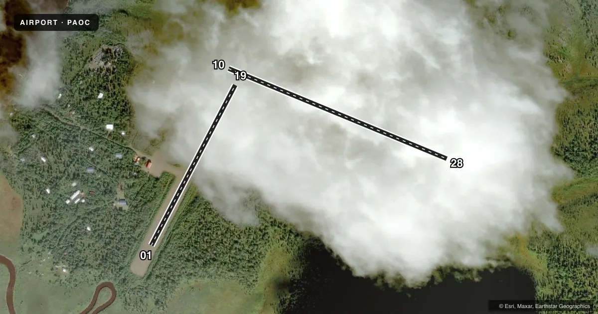
Runways & pattern
Full pagePattern entry · RWY 19
LEFT TRAFFIC| Runway | Heading (°M) | Length | Surface | Traffic |
|---|---|---|---|---|
| 10/28 | 91° / 271° | 1,920 ft | GRVL-DIRT | Standard L |
| 01/19Favored | 6° / 186° | 1,470 ft | GRVL-DIRT | Standard L |
Runway end performance
| End | TORA | TODA | ASDA | LDA | VGSI | Approach lights | Obstruction |
|---|---|---|---|---|---|---|---|
| 10 | — | — | — | — | — | — | 8', brush, 0' from thr, 0' R of cntrln, slope 0 |
| 28 | — | — | — | — | — | — | 10', brush, 0' from thr, 50' R of cntrln, slope 0 |
| 01 | — | — | — | — | — | — | 25', trees, 0' from thr, 120' R of cntrln, slope 0 |
| 19 | — | — | — | — | — | — | 6', brush, 0' from thr, 85' R of cntrln, slope 0 |
Declared distances in feet. TORA = takeoff run available, TODA = takeoff distance, ASDA = accelerate-stop, LDA = landing distance.
Airport sketch
Runways drawn to scale from FAA survey coordinates, rendered over satellite imagery. Not for navigation.
Approaches & charts
Services on the field
Fuel grades, oxygen, maintenance, ramp storage and lighting — as declared to the FAA by the airport operator.
Fuel & services
- Fuel
- Not available
- Oxygen (bottled)
- Not available
- Oxygen (bulk)
- Not available
- Airframe repair
- Not available
- Power plant repair
- Not available
Ramp & ground
- Transient storage
- Not published
- Landing fee
- No fee published
- Customs
- Not available
- Wind indicator
- Yes
- Segmented circle
- Yes
Fuel & FBOs
Cheapest 100LL and Jet A on the field and nearby. Always confirm with the FBO before taxi.
Airport notes
Surface conditions, obstructions, local procedures, lighting outages and other notes published with each FAA cycle.
General notes
- RWY COND NOT MNT; RCMD VISUAL INSPN PRIOR TO USING, NO MAINT ON ARPT.
- RWY 10 & RWY 01 - SAFETY AREAS SOFT; MAY BE UNUSBL. RWY 28 SAFETY AREA ERODING NEAR BLUFF.
- RWY VERY SOFT; DEEP RUTS MAY DEVELOP WHEN SFC WET.
- WX CAMERA AVBL ON INTERNET AT HTTPS://WEATHERCAMS.FAA.GOV
- BRUSH AND TREES ENCROACHING ON ALL RWY SFCS.
- NO SNOW REMOVAL RWY 10/28.
Runway surface & condition
- 10/28SLOPES UP TO E END 1.5 %. NO LINE OF SIGHT BETWEEN RWY ENDS.
Approach & departure obstructions
- 01RWY 01/19 MKD WITH REFLECTIVE ORANGE CONES.
- 10RWY MKD WITH REFLECTIVE ORANGE CONES.
Other notes
- VEGETATION OVERGROWING SEG CIRCLE.
- 01/19RWY 01/19 SFC RUTS 4 IN TO 6 IN DEEP 300 FT FM THLD RWY 01 WHERE ACFT TURN ARND FOR TKOF.
- 10/28VERY SOFT WITH DEEP LOOSE GRVL. FIRST 200 FT OF RWY 28 CLSD WITH BRUSH GROWING ON EDGES.
VFR map & nearby airports
VFR sectional. Tap any ICAO chip to open that airport.
Key facts · PAOC
Answer card- ICAO
- PAOC
- Name
- PORTAGE CREEK
- Location
- PORTAGE CREEK, ALASKA
- Elevation
- 129 ft MSL
- Traffic pattern altitude
- 1,129 ft MSL (1,000 AGL)
- Control tower
- Non-towered (use CTAF)
- Total runways
- 2
- Longest runway
- 10/28 · 1,920 ft
- Published ILS approaches
- 0
- Published frequencies
- 1
- Magnetic variation
- 21°
- Current flight rules
- MVFR
- Current wind
- 240° at 15 kt
- Favored runway now
- RWY 19
Portage Creek Airport sits in Portage Creek, Alaska. Field elevation is 129 ft MSL. The airport has two runways. The longest is runway 10/28 at 1,920 ft. There is no control tower. CTAF is 122.9.
No ILS approaches are published here. Pattern altitude is not published, so use the standard 1,000 ft AGL for light piston operations unless the current Chart Supplement says otherwise. The field is rough and not maintained. A preflight walk or low pass inspection makes sense before committing. Runway 10/28 is very soft with deep loose gravel. The first 200 feet of runway 28 is closed with brush along the edges. Runway 10/28 also slopes up toward the east end. There is no line of sight between runway ends.
Runway 01/19 is 1,470 ft long. It is marked with reflective orange cones. Runway 01 also has deep ruts reported about 300 feet from the threshold where aircraft turn around for takeoff. Brush and trees are encroaching on all runway surfaces. No snow removal is provided on runway 10/28. There are no on-field FBOs listed. Check the current FAA Chart Supplement or call the airport operator before you go. A weather camera is available online for a current look at field conditions.