METAR & TAF PFCL
Current METAR
Observed 13:56Z
PFCL 281356Z AUTO 18010KT 10SM OVC013 A3015 RMK AO2 SLPNO FZRANO PNO $
- Wind
- 180° @ 10 kt
- Visibility
- 10 SM
- Temp / Dew
- —
- Altimeter
- 30.15 inHg
- Clouds
- OVC
- Density alt
- —
- Ceiling
- 1,300 ft AGL
- Rules
- MVFR
Airport info & contacts
Manager on record, flight service, ARTCC, attendance schedule and pattern altitude — published by the FAA and refreshed every 28 days.
Location
- From city
- 1 NM E
- VFR sectional
- KODIAK
- ARTCC
- ZAN · ANCHORAGE
- NOTAM facility
- CLP (NOTAM-D)
Airport manager
- Name
- KEVIN HARDIN
- Phone
- 907-842-5511
- Address
- BOX 250, DILLINGHAM AK 99576
Flight service · Hours
- FSS DLG
- DILLINGHAM907-842-5275LC842-5275
- Attendance
- Unattended
Frequencies
Tap any row to copy the frequency to your clipboard.
Runways & pattern
Full pagePattern entry · RWY 18
LEFT TRAFFICRunway end performance
| End | TORA | TODA | ASDA | LDA | VGSI | Approach lights | Obstruction |
|---|---|---|---|---|---|---|---|
| 18 | — | — | — | — | — | — | 10', brush, 0' from thr, 128' R of cntrln, slope 0 |
| 36 | — | — | — | — | — | — | 6', brush, 0' from thr, 209' R of cntrln, slope 0 |
Declared distances in feet. TORA = takeoff run available, TODA = takeoff distance, ASDA = accelerate-stop, LDA = landing distance.
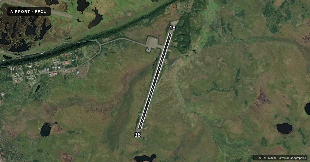
Airport sketch
Runways drawn to scale from FAA survey coordinates, rendered over satellite imagery. Not for navigation.
Approaches & charts
Services on the field
Fuel grades, oxygen, maintenance, ramp storage and lighting — as declared to the FAA by the airport operator.
Fuel & services
- Fuel
- Not available
- Oxygen (bottled)
- Not available
- Oxygen (bulk)
- Not available
- Airframe repair
- Not available
- Power plant repair
- Not available
Ramp & ground
- Transient storage
- Not published
- Landing fee
- No fee published
- Customs
- Not available
- Lighting schedule
- SEE RMK
- Beacon schedule
- SEE RMK
- Beacon
- White / Green (civil land)(WG)
- Wind indicator
- Lighted
- Segmented circle
- Yes
Fuel & FBOs
Cheapest 100LL and Jet A on the field and nearby. Always confirm with the FBO before taxi.
Airport notes
Surface conditions, obstructions, local procedures, lighting outages and other notes published with each FAA cycle.
General notes
- RWY COND NOT MONITORED; RCMD VISUAL INSPECTION PRIOR TO LNDG.
- BIRDS & MOOSE INVOF RWY.
- WX CAMERA AVBL ON INTERNET AT HTTPS://WEATHERCAMS.FAA.GOV
- ATV CROSS RWY 18 FM TWY TO THLD.
Lighting notes
- ACTVT ROTG BCN - CTAF.
- ACTVT MIRL RWY 18/36; WINDSOCK - CTAF.
Approach & departure obstructions
- 18CONTROLLING OBSTRUCTION EXCEEDS A 45 DEGREE SLOPE
Other notes
- THIS AIRPORT HAS BEEN SURVEYED BY THE NATIONAL GEODETIC SURVEY.
VFR map & nearby airports
VFR sectional. Tap any ICAO chip to open that airport.
Key facts · PFCL
Answer card- ICAO
- PFCL
- Name
- CLARKS POINT
- Location
- CLARKS POINT, ALASKA
- Elevation
- 79.6 ft MSL
- Traffic pattern altitude
- 1,079.6 ft MSL (1,000 AGL)
- Control tower
- Non-towered (use CTAF)
- Total runways
- 1
- Longest runway
- 18/36 · 3,200 ft
- Published ILS approaches
- 0
- Published frequencies
- 1
- Magnetic variation
- 15°
- Current flight rules
- MVFR
- Current wind
- 180° at 10 kt
- Favored runway now
- RWY 18
Clarks Point Airport sits in Clarks Point, Alaska. Field elevation is 79.6 ft MSL. The airport has one runway. Runway 18/36 is 3,200 ft long and gravel. There is no control tower. CTAF is 122.9. No ILS approaches are published here.
Pattern altitude is not published. Use standard 1,000 ft AGL for light piston operations unless local guidance says otherwise. The published runway headings are magnetic. Runway 18/36 is listed at 198°/18°. The field has medium intensity runway lights on 18/36. The rotating beacon is also activated on CTAF. The windsock is on CTAF too.
There are no on-field FBOs listed. Check with the airport operator or the FBO directly by phone before arrival if you need fuel or handling. Published remarks say runway condition is not monitored, so a visual inspection before landing is a good idea. Birds and moose are in the area. All-terrain vehicles also cross runway 18 from the taxiway to the threshold. The controlling obstruction at runway 18 exceeds a 45 degree slope. A weather camera is available online for a preflight look. This is a small Alaska field with no tower and no published ILS. Plan for self-announce traffic, short-field judgment and a careful scan of the surface and runway environment.