METAR & TAF PAMB
Current METAR
Observed 11:10Z
PAMB 281110Z AUTO 23005KT 10SM BKN006 07/07 A3013 RMK AO2
- Wind
- 230° @ 5 kt
- Visibility
- 10 SM
- Temp / Dew
- 7°C / 7°C
- Altimeter
- 30.13 inHg
- Clouds
- BKN
- Density alt
- -1,088 ft
- Ceiling
- 600 ft AGL
- Rules
- IFR
Airport info & contacts
Manager on record, flight service, ARTCC, attendance schedule and pattern altitude — published by the FAA and refreshed every 28 days.
Location
- From city
- 6 NM ESE
- VFR sectional
- KODIAK
- ARTCC
- ZAN · ANCHORAGE
- NOTAM facility
- MBA (NOTAM-D)
Airport manager
- Name
- KEVIN HARDIN
- Phone
- 907-842-5511
- Address
- BOX 250, DILLINGHAM AK 99576
Flight service · Hours
- FSS DLG
- DILLINGHAM907-842-5275LC842-5275
- Attendance
- Unattended
Frequencies
Tap any row to copy the frequency to your clipboard.
Runways & pattern
Full pagePattern entry · RWY 21
LEFT TRAFFICRunway end performance
| End | TORA | TODA | ASDA | LDA | VGSI | Approach lights | Obstruction |
|---|---|---|---|---|---|---|---|
| 03 | — | — | — | — | — | — | 8', tree, 0' from thr, 231' R of cntrln, slope 0 |
| 21 | — | — | — | — | — | — | 8', tree, 65' from thr, 210' R of cntrln, slope 8 |
Declared distances in feet. TORA = takeoff run available, TODA = takeoff distance, ASDA = accelerate-stop, LDA = landing distance.
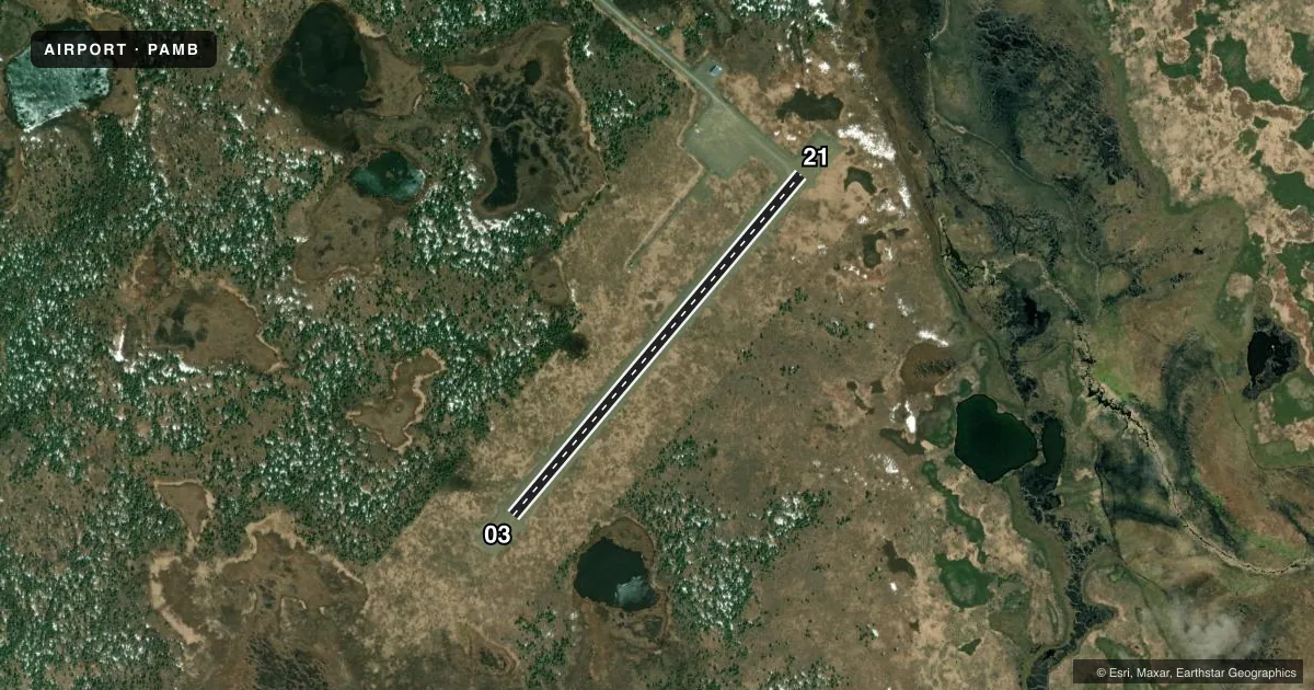
Airport sketch
Runways drawn to scale from FAA survey coordinates, rendered over satellite imagery. Not for navigation.
Approaches & charts
Services on the field
Fuel grades, oxygen, maintenance, ramp storage and lighting — as declared to the FAA by the airport operator.
Fuel & services
- Fuel
- Not available
- Other services
- CARGO
Ramp & ground
- Transient storage
- Tie-down
- Landing fee
- No fee published
- Customs
- Not available
- Lighting schedule
- SEE RMK
- Beacon schedule
- SEE RMK
- Beacon
- White / Green (civil land)(WG)
- Wind indicator
- Lighted
- Segmented circle
- Yes
Fuel & FBOs
Cheapest 100LL and Jet A on the field and nearby. Always confirm with the FBO before taxi.
Airport notes
Surface conditions, obstructions, local procedures, lighting outages and other notes published with each FAA cycle.
General notes
- WX CAMERA AVBL ON INTERNET AT HTTPS://WEATHERCAMS.FAA.GOV
- RCMD VISUAL INSP BFR USE.
- WILDLIFE ON & INVOF ARPT.
Lighting notes
- ACTVT ROTG BCN - CTAF.
- ACTVT MIRL RWY 03/21; WINDSOCK LGT - CTAF.
Runway surface & condition
- 03/21SAFETY AREA 3900 FT X 150 FT.
VFR map & nearby airports
VFR sectional. Tap any ICAO chip to open that airport.
Key facts · PAMB
Answer card- ICAO
- PAMB
- Name
- MANOKOTAK
- Location
- MANOKOTAK, ALASKA
- Elevation
- 106.6 ft MSL
- Traffic pattern altitude
- 1,106.6 ft MSL (1,000 AGL)
- Control tower
- Non-towered (use CTAF)
- Total runways
- 1
- Longest runway
- 03/21 · 3,300 ft
- Published ILS approaches
- 0
- Published frequencies
- 1
- Magnetic variation
- 16°
- Current flight rules
- IFR
- Current wind
- 230° at 5 kt
- Favored runway now
- RWY 21
Manokotak Airport sits in Manokotak, Alaska. Field elevation is 106.6 ft MSL. The airport has one runway, 03/21, which is 3,300 ft long and gravel. Runway headings are 40° and 220° magnetic. There is no control tower. CTAF is 122.9.
No ILS approaches are published here. Pattern altitude is not published, so use the standard 1,000 ft AGL for light piston operations unless the current Chart Supplement says otherwise. With a field elevation of 106.6 ft MSL, that puts a normal light-aircraft pattern near 1,106.6 ft MSL. Check the current Chart Supplement before you go. The published remarks also note a weather camera online. They also note medium intensity runway lights for 03/21 and the windsock light on CTAF. The rotating beacon also works from CTAF.
There are no on-field FBOs listed. Wildlife is present on and near the airport. A visual inspection is recommended before use, which matters on a gravel strip like this. Plan for a remote Alaska field with no tower and no published precision approach. Verify current conditions, lighting use and any local procedures with the airport operator or the current FAA Chart Supplement before departure.