METAR & TAF A63
A63 does not publish a METAR.
Showing the nearest reporting station: PATG (TOGIAK) · 4.0 NM away. Conditions at A63 may differ.
METAR · PATG
Observed 12:56Z
PATG 281256Z AUTO 15007KT 10SM SCT019 BKN040 OVC060 09/08 A2989 RMK AO2 SLP122 T00890078
- Wind
- 150° @ 7 kt
- Visibility
- 10 SM
- Temp / Dew
- 9°C / 8°C
- Altimeter
- 29.89 inHg
- Clouds
- OVC
- Density alt
- -581 ft
- Ceiling
- 4,000 ft AGL
- Rules
- VFR
Airport info & contacts
Manager on record, flight service, ARTCC, attendance schedule and pattern altitude — published by the FAA and refreshed every 28 days.
Location
- From city
- 0 NM E
- VFR sectional
- KODIAK
- ARTCC
- ZAN · ANCHORAGE
- NOTAM facility
- ENA (NOTAM-D)
Airport manager
- Name
- KEVIN HARDIN
- Phone
- 907-842-5511
- Address
- BOX 250, DILLINGHAM AK 99576
Flight service · Hours
- FSS ENA
- KENAI907-283-72111-866-864-1737
- Attendance
- Unattended
Frequencies
Tap any row to copy the frequency to your clipboard.
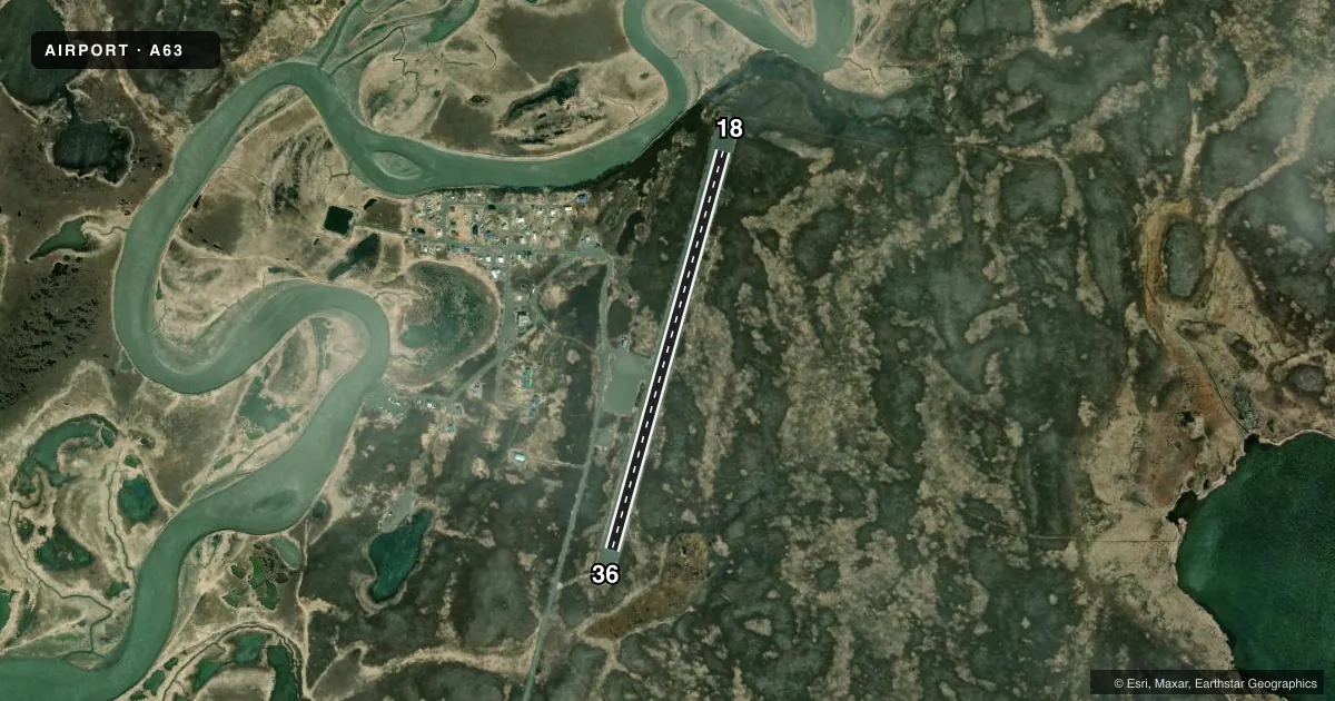
Runways & pattern
Full pagePattern entry · RWY 18
RIGHT TRAFFICRunway end performance
| End | TORA | TODA | ASDA | LDA | VGSI | Approach lights | Obstruction |
|---|---|---|---|---|---|---|---|
| 36 | — | — | — | — | — | — | 5', brush, 0' from thr, 80' R of cntrln, slope 0 |
Declared distances in feet. TORA = takeoff run available, TODA = takeoff distance, ASDA = accelerate-stop, LDA = landing distance.
Airport sketch
Runways drawn to scale from FAA survey coordinates, rendered over satellite imagery. Not for navigation.
Approaches & charts
Services on the field
Fuel grades, oxygen, maintenance, ramp storage and lighting — as declared to the FAA by the airport operator.
Fuel & services
- Fuel
- Not available
Ramp & ground
- Transient storage
- Not published
- Landing fee
- No fee published
- Customs
- Not available
- Lighting schedule
- SEE RMK
- Beacon schedule
- SEE RMK
- Beacon
- White / Green (civil land)(WG)
- Wind indicator
- Yes
- Segmented circle
- Yes
Fuel & FBOs
Cheapest 100LL and Jet A on the field and nearby. Always confirm with the FBO before taxi.
Airport notes
Surface conditions, obstructions, local procedures, lighting outages and other notes published with each FAA cycle.
General notes
- CTN: TURB PSBL WHEN LNDG S DUE TO N BLUFF.
- RWY COND UNMNT; RCMD VISUAL INSP BFR TO USE.
Lighting notes
- ACTVT ROTG BCN - CTAF.
- ACTVT MIRL RWY 18/36 - CTAF.
Runway surface & condition
- 18/362 PCT UPHILL SLOPE TO N.
VFR map & nearby airports
VFR sectional. Tap any ICAO chip to open that airport.
Key facts · A63
Answer card- ICAO
- A63
- Name
- TWIN HILLS
- Location
- TWIN HILLS, ALASKA
- Elevation
- 82 ft MSL
- Traffic pattern altitude
- 1,082 ft MSL (1,000 AGL)
- Control tower
- Non-towered (use CTAF)
- Total runways
- 1
- Longest runway
- 18/36 · 3,000 ft
- Published ILS approaches
- 0
- Published frequencies
- 1
- Magnetic variation
- 19°
- Current flight rules
- VFR
- Current wind
- 150° at 7 kt
- Favored runway now
- RWY 18
Twin Hills Airport sits in Twin Hills, Alaska. Field elevation is 82 ft MSL. The airport has one runway. Runway 18/36 is 3,000 ft of gravel. It is the longest runway on the field. There is no control tower. CTAF is 122.5.
No ILS approaches are published here. Pattern altitude is not published in the facts, so use the standard 1,000 ft AGL for light piston operations unless the current Chart Supplement says otherwise. The runway has a 2 percent uphill slope to the north. Runway condition is unmonitored, so a visual check before use is smart. The rotating beacon is activated by CTAF. Medium intensity runway lights for 18/36 are also CTAF-activated.
There are no on-field FBOs listed in the facts. Check with the airport operator or the field directly for current services before you go. Pilots should also plan for the north bluff. Turbulence is possible when landing south. Magnetic variation is 19°, so keep runway headings and local navigation aligned with magnetic references.