METAR & TAF PATG
Current METAR
Observed 07:56Z
PATG 280756Z AUTO 20013KT 10SM BKN022 BKN028 OVC032 09/08 A2994 RMK AO2 SLP138 T00890078 401170072
- Wind
- 200° @ 13 kt
- Visibility
- 10 SM
- Temp / Dew
- 9°C / 8°C
- Altimeter
- 29.94 inHg
- Clouds
- OVC
- Density alt
- -722 ft
- Ceiling
- 2,200 ft AGL
- Rules
- MVFR
Airport info & contacts
Manager on record, flight service, ARTCC, attendance schedule and pattern altitude — published by the FAA and refreshed every 28 days.
Location
- From city
- 0 NM SW
- VFR sectional
- KODIAK
- ARTCC
- ZAN · ANCHORAGE
- NOTAM facility
- TOG (NOTAM-D)
Airport manager
- Name
- KEVIN HARDIN
- Phone
- 907-842-5511
- Address
- BOX 214, DILLINGHAM AK 99576
Flight service · Hours
- FSS ENA
- KENAI907-283-72111-866-864-1737
- Attendance
- Unattended
Frequencies
Tap any row to copy the frequency to your clipboard.
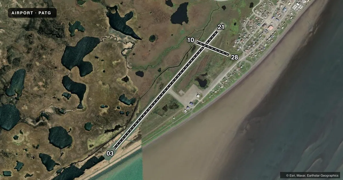
Runways & pattern
Full pagePattern entry · RWY 21
LEFT TRAFFIC| Runway | Heading (°M) | Length | Surface | Traffic |
|---|---|---|---|---|
| 03/21Favored | 31° / 211° | 4,400 ft | GRVL-DIRT | Standard L |
| 10/28 | 101° / 281° | 982 ft | GRVL | Standard L |
Runway end performance
| End | TORA | TODA | ASDA | LDA | VGSI | Approach lights | Obstruction |
|---|---|---|---|---|---|---|---|
| 03 | — | — | — | — | PAPI 4-box left(3°) | — | 15', road, 0' from thr, 100' R of cntrln, slope 0 |
| 21 | — | — | — | — | PAPI 4-box left(3°) | — | — |
| 28 | — | — | — | — | — | — | 41', bldg, 270' from thr, 163' R of cntrln, slope 11 |
Declared distances in feet. TORA = takeoff run available, TODA = takeoff distance, ASDA = accelerate-stop, LDA = landing distance.
Airport sketch
Runways drawn to scale from FAA survey coordinates, rendered over satellite imagery. Not for navigation.
Approaches & charts
Services on the field
Fuel grades, oxygen, maintenance, ramp storage and lighting — as declared to the FAA by the airport operator.
Fuel & services
- Fuel
- Not available
- Other services
- CARGO
Ramp & ground
- Transient storage
- Tie-down
- Landing fee
- No fee published
- Customs
- Not available
- Lighting schedule
- SEE RMK
- Beacon schedule
- SEE RMK
- Beacon
- White / Green (civil land)(WG)
- Wind indicator
- Lighted
- Segmented circle
- Yes
Fuel & FBOs
Cheapest 100LL and Jet A on the field and nearby. Always confirm with the FBO before taxi.
Airport notes
Surface conditions, obstructions, local procedures, lighting outages and other notes published with each FAA cycle.
General notes
- RWY COND UNMNT, RCMD VISUAL INSP BFR USE.
- WX CAMERAS AVBL ON INTERNET AT HTTPS://WEATHERCAMS.FAA.GOV
- WATERFOWL INVOF ARPT.
Lighting notes
- ACTVT ROTG BCN - CTAF.
- ACTVT PAPI RWY 03 & 21; MIRL RWY 03/21 - CTAF.
Approach & departure obstructions
- 10THR MKRS DMGD OR MISG.
- 28THR MKRS DMGD OR MISG.
- 03CTLG OBSTN EXCEEDS A 45 DEG SLOPE.
- 03+15 FT.
VFR map & nearby airports
VFR sectional. Tap any ICAO chip to open that airport.
Key facts · PATG
Answer card- ICAO
- PATG
- Name
- TOGIAK
- Location
- TOGIAK VILLAGE, ALASKA
- Elevation
- 18.6 ft MSL
- Traffic pattern altitude
- 1,018.6 ft MSL (1,000 AGL)
- Control tower
- Non-towered (use CTAF)
- Total runways
- 2
- Longest runway
- 03/21 · 4,400 ft
- Published ILS approaches
- 0
- Published frequencies
- 1
- Magnetic variation
- 11°
- Current flight rules
- MVFR
- Current wind
- 200° at 13 kt
- Favored runway now
- RWY 21
Togiak Airport sits in Togiak Village, Alaska. Field elevation is 18.6 ft MSL. The airport has two runways. The longest is 4,400 ft on runway 03/21. This is an uncontrolled field with no tower. CTAF is 122.5.
No ILS approaches are published here. Pattern altitude is not published, so verify the current traffic pattern in the FAA Chart Supplement before you go. The published remarks matter here. Runway conditions are unmonitored, so plan a visual inspection before use. There is a 15-foot obstruction at the runway 03 end. Threshold markers on runway 10 are damaged or missing. Threshold markers on runway 28 are damaged or missing. Waterfowl are also reported in the area.
Lighting is CTAF-activated. That includes the rotating beacon. It also includes the PAPI and medium intensity runway lights on runways 03 and 21. No on-field FBOs are listed, so contact the airport operator directly or call the field on CTAF for current service details before arrival. For a first-time pilot, the big items are the short gravel strips, the published obstruction near runway 03 and the need to check runway condition before committing. Weather cameras are available online if you want another look before departure.