METAR & TAF 5A8
5A8 does not publish a METAR.
Showing the nearest reporting station: PADL (DILLINGHAM) · 14.7 NM away. Conditions at 5A8 may differ.
METAR · PADL
Observed 12:56Z
PADL 281256Z AUTO 22005KT 10SM FEW008 BKN048 07/07 A3013
- Wind
- 220° @ 5 kt
- Visibility
- 10 SM
- Temp / Dew
- 7°C / 7°C
- Altimeter
- 30.13 inHg
- Clouds
- BKN
- Density alt
- -1,142 ft
- Ceiling
- 4,800 ft AGL
- Rules
- VFR
Airport info & contacts
Manager on record, flight service, ARTCC, attendance schedule and pattern altitude — published by the FAA and refreshed every 28 days.
Location
- From city
- 1 NM E
- VFR sectional
- KODIAK
- ARTCC
- ZAN · ANCHORAGE
- NOTAM facility
- DLG (NOTAM-D)
Airport manager
- Name
- KEVIN HARDIN
- Phone
- 907-842-5511
- Address
- BOX 250, DILLINGHAM AK 99576
Flight service · Hours
- FSS DLG
- DILLINGHAM907-842-5275LC842-5275
- Attendance
- Unattended
Frequencies
Tap any row to copy the frequency to your clipboard.
Runways & pattern
Full pagePattern entry · RWY 15
LEFT TRAFFICRunway end performance
| End | TORA | TODA | ASDA | LDA | VGSI | Approach lights | Obstruction |
|---|---|---|---|---|---|---|---|
| 15 | — | — | — | — | — | — | 9', tree, 0' from thr, 84' R of cntrln, slope 0 |
| 33 | — | — | — | — | — | — | 6', brush, 0' from thr, 50' R of cntrln, slope 0 |
Declared distances in feet. TORA = takeoff run available, TODA = takeoff distance, ASDA = accelerate-stop, LDA = landing distance.
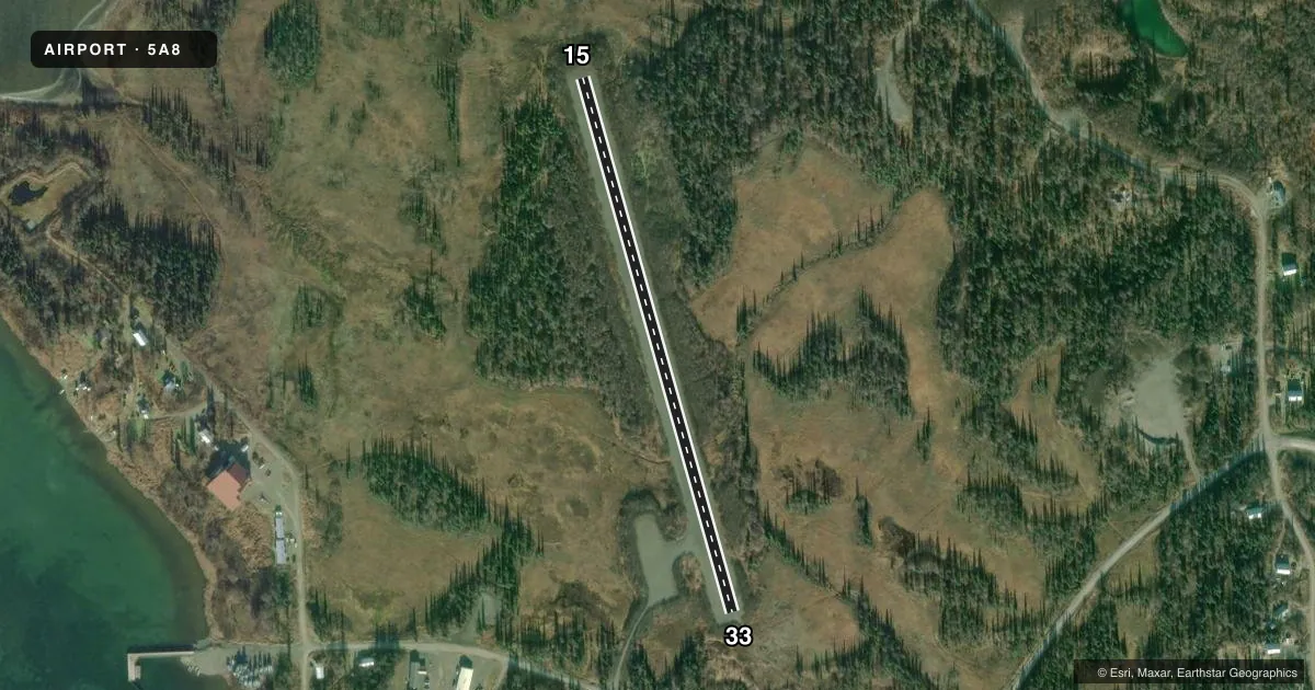
Airport sketch
Runways drawn to scale from FAA survey coordinates, rendered over satellite imagery. Not for navigation.
Approaches & charts
Services on the field
Fuel grades, oxygen, maintenance, ramp storage and lighting — as declared to the FAA by the airport operator.
Fuel & services
- Fuel
- Not available
Ramp & ground
- Transient storage
- Tie-down
- Wind indicator
- Yes
Fuel & FBOs
Cheapest 100LL and Jet A on the field and nearby. Always confirm with the FBO before taxi.
Airport notes
Surface conditions, obstructions, local procedures, lighting outages and other notes published with each FAA cycle.
General notes
- RWY COND NOT MONITORED; RCMD VISUAL INSPECTION PRIOR TO USE. NO SNOW REMOVAL.
- BE ALERT: FLOAT PLANES LNDG & DEPG BTN N AND S SHORES ON THE ALEKNAGIK IN THE AREAS OF ALEKNAGIK LODGE & MOSQUITO POINT.
- BE ALERT: RWY ELEVD ABV SRNDG TRRN; NO SAFETY AREAS AT EITHER THLD.
- RWY SLOPES DOWN TOWARD DEP END OF RWY 15.
- TREES ON APCH OF RWY 15, PWR LINES ON APCH OF RWY 33.
- LOOSE ROCKS ON RWY.
- SEGMENTED CIRCLE IS OVERGROWN AND UNUSEABLE
Approach & departure obstructions
- 15RWY 15/33 MKD WITH ORANGE 3 FT CONES.
Other notes
- THE WINDSOCK IS FADED AND BELOW THE TREE LINE; MAY BE UNREL.
VFR map & nearby airports
VFR sectional. Tap any ICAO chip to open that airport.
Key facts · 5A8
Answer card- ICAO
- 5A8
- Name
- ALEKNAGIK /NEW
- Location
- ALEKNAGIK, ALASKA
- Elevation
- 63 ft MSL
- Traffic pattern altitude
- 1,063 ft MSL (1,000 AGL)
- Control tower
- Non-towered (use CTAF)
- Total runways
- 1
- Longest runway
- 15/33 · 2,030 ft
- Published ILS approaches
- 0
- Published frequencies
- 1
- Magnetic variation
- 20°
- Current flight rules
- VFR
- Current wind
- 220° at 5 kt
- Favored runway now
- RWY 15
ALEKNAGIK /NEW (5A8) is in Aleknagik, Alaska. The field elevation is 63 ft MSL. It has one runway, 15/33, which is 2,030 ft long and gravel. There is no control tower. CTAF is 122.9. No ILS approaches are published here.
The published pattern altitude is not listed, so use the standard 1,000 ft AGL for light piston operations unless the current FAA Chart Supplement says otherwise. The runway is marked with orange 3-foot cones. The runway slopes down toward the departure end of runway 15. Loose rocks are reported on the surface. Trees affect the approach to runway 15. Power lines affect the approach to runway 33. The segmented circle is overgrown and unusable.
This is a field where a careful visual check matters. The runway is elevated above the surrounding terrain. There are no safety areas at either threshold. The windsock is faded and below the tree line, so treat wind cues with caution. Float planes also operate between the north and south shores on the Aleknagik near Aleknagik Lodge and Mosquito Point. There are no on-field FBOs listed. Verify current services with the airport operator or by calling the field on CTAF before arrival.