METAR & TAF PFWS
Current METAR
Observed 21:37Z
PFWS 272137Z AUTO 26016G23KT 10SM OVC016 11/06 A3007 RMK AO2
- Wind
- 260° @ 16G23 kt
- Visibility
- 10 SM
- Temp / Dew
- 11°C / 6°C
- Altimeter
- 30.07 inHg
- Clouds
- OVC
- Density alt
- -465 ft
- Ceiling
- 1,600 ft AGL
- Rules
- MVFR
Airport info & contacts
Manager on record, flight service, ARTCC, attendance schedule and pattern altitude — published by the FAA and refreshed every 28 days.
Location
- From city
- 1 NM SSW
- VFR sectional
- KODIAK
- ARTCC
- ZAN · ANCHORAGE
- NOTAM facility
- WSN (NOTAM-D)
Airport manager
- Name
- FLOYD WILSON
- Phone
- 907-246-3325
- Address
- PO BOX 65, KING SALMON AK 99613
Flight service · Hours
- FSS ENA
- KENAI907-283-72111-866-864-1737
- Attendance
- Unattended
Frequencies
Tap any row to copy the frequency to your clipboard.
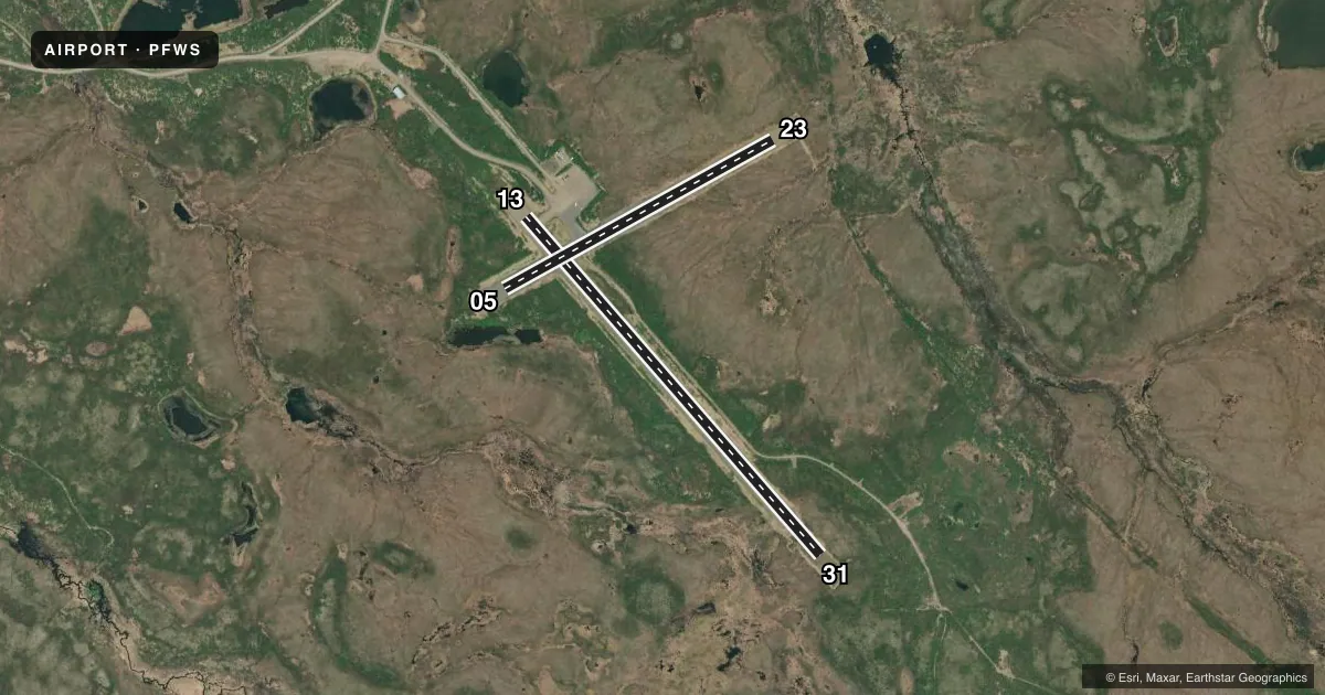
Runways & pattern
Full pagePattern entry · RWY 23
LEFT TRAFFIC| Runway | Heading (°M) | Length | Surface | Traffic |
|---|---|---|---|---|
| 13/31 | 126° / 306° | 3,314 ft | GRVL-DIRT | Standard L |
| 05/23Favored | 48° / 228° | 2,264 ft | GRVL-DIRT | Standard L |
Runway end performance
| End | TORA | TODA | ASDA | LDA | VGSI | Approach lights | Obstruction |
|---|---|---|---|---|---|---|---|
| 13 | — | — | — | — | VASI 2-box left(3°) | — | 9', brush, 4' from thr, 95' R of cntrln, slope 0 |
| 31 | — | — | — | — | — | — | 6', brush, 0' from thr, 72' R of cntrln, slope 0 |
| 05 | — | — | — | — | — | — | 20', brush, 0' from thr, 115' R of cntrln, slope 0 |
| 23 | — | — | — | — | — | — | 7', brush, 0' from thr, 71' R of cntrln, slope 0 |
Declared distances in feet. TORA = takeoff run available, TODA = takeoff distance, ASDA = accelerate-stop, LDA = landing distance.
Airport sketch
Runways drawn to scale from FAA survey coordinates, rendered over satellite imagery. Not for navigation.
Approaches & charts
Services on the field
Fuel grades, oxygen, maintenance, ramp storage and lighting — as declared to the FAA by the airport operator.
Fuel & services
- Fuel
- Not available
Ramp & ground
- Transient storage
- Not published
- Landing fee
- No fee published
- Customs
- Not available
- Lighting schedule
- SEE RMK
- Beacon schedule
- SS-SR
- Beacon
- White / Green (civil land)(WG)
- Wind indicator
- Lighted
- Segmented circle
- Yes
Fuel & FBOs
Cheapest 100LL and Jet A on the field and nearby. Always confirm with the FBO before taxi.
Airport notes
Surface conditions, obstructions, local procedures, lighting outages and other notes published with each FAA cycle.
General notes
- RWY COND UNMNT; RCMND VISUAL INSP PRIOR TO USE.
- TWY SLPS DOWNHILL TO NW; NO LINE OF SIGHT BTN END OF TWY & RWY 13/31.
- WX CAMERA AVBL ON INTERNET AT HTTPS://WEATHERCAMS.FAA.GOV
- VEHICLES, MOOSE & BEARS ON & INVOF RWYS.
- HVY TFC BTN S NAKNEK & NAKNEK ARPTS LESS THAN 2 MI APART.
Lighting notes
- ACTVT VASI RWY 13; HIRL RWY 05/23 & 13/31 - CTAF.
Approach & departure obstructions
- 31SHORT CONES & LIGHTS.
Other notes
- THIS AIRPORT HAS BEEN SURVEYED BY THE NATIONAL GEODETIC SURVEY.
VFR map & nearby airports
VFR sectional. Tap any ICAO chip to open that airport.
Key facts · PFWS
Answer card- ICAO
- PFWS
- Name
- SOUTH NAKNEK NR 2
- Location
- SOUTH NAKNEK, ALASKA
- Elevation
- 162.3 ft MSL
- Traffic pattern altitude
- 1,162.3 ft MSL (1,000 AGL)
- Control tower
- Non-towered (use CTAF)
- Total runways
- 2
- Longest runway
- 13/31 · 3,314 ft
- Published ILS approaches
- 0
- Published frequencies
- 1
- Magnetic variation
- 13°
- Current flight rules
- MVFR
- Current wind
- 260° at 16 kt
- Favored runway now
- RWY 23
South Naknek Nr 2 Airport sits in South Naknek, Alaska. Field elevation is 162.3 ft MSL. It has two runways. The longest is 13/31 at 3,314 ft. This is a non-towered field, so plan on CTAF work on 122.9 and standard self-announce discipline. No ILS approaches are published here.
Pattern altitude is not published. Use 1,000 ft AGL for light piston operations unless the current Chart Supplement says otherwise. Runway surfaces are gravel-dirt. Runway 31 has short cones and lights. Visual approach slope indicator for runway 13 and the high intensity runway lights for 05/23 and 13/31 are activated on CTAF. Runway condition is unmonitored. A visual inspection before use is a good idea.
There are no on-field FBOs listed. Check with the airport operator or the FBO directly by phone before arrival if you need services. Be ready for wildlife on and near the runways. Moose and bears are specifically called out. Taxiway geometry also matters here. The taxiway slopes down to the northwest. There is no line of sight between the taxiway end and runway 13/31. Heavy traffic can occur between South Naknek and Naknek airports. They are less than 2 miles apart. Review the current Chart Supplement before you go.