METAR & TAF PAII
Current METAR
Observed 07:56Z
PAII 280756Z AUTO 23004KT 10SM BKN036 OVC049 08/07 A3015 RMK AO2 SLP208 T00830067 401220067
- Wind
- 230° @ 4 kt
- Visibility
- 10 SM
- Temp / Dew
- 8°C / 7°C
- Altimeter
- 30.15 inHg
- Clouds
- OVC
- Density alt
- -1,011 ft
- Ceiling
- 3,600 ft AGL
- Rules
- VFR
Airport info & contacts
Manager on record, flight service, ARTCC, attendance schedule and pattern altitude — published by the FAA and refreshed every 28 days.
Location
- From city
- 2 NM S
- VFR sectional
- KODIAK
- ARTCC
- ZAN · ANCHORAGE
- NOTAM facility
- EII (NOTAM-D)
Airport manager
- Name
- BILL YOST
- Phone
- 907-233-2400
- Address
- PO BOX 189, EGEGIK AK 99579
Flight service · Hours
- FSS ENA
- KENAI907-283-72111-866-864-1737
- Attendance
- Unattended
Frequencies
Tap any row to copy the frequency to your clipboard.
Runways & pattern
Full pagePattern entry · RWY 21
LEFT TRAFFIC| Runway | Heading (°M) | Length | Surface | Traffic |
|---|---|---|---|---|
| 12/30 | 127° / 307° | 5,600 ft | GRVL | Standard L |
| 03/21Favored | 37° / 217° | 1,500 ft | GRVL-DIRT | Standard L |
Runway end performance
| End | TORA | TODA | ASDA | LDA | VGSI | Approach lights | Obstruction |
|---|---|---|---|---|---|---|---|
| 12 | — | — | — | — | PAPI 4-box left(3°) | — | 8', brush, 0' from thr, 245' R of cntrln, slope 0 |
| 30 | — | — | — | — | — | — | 6', brush, 0' from thr, 245' R of cntrln, slope 0 |
| 03 | — | — | — | — | — | — | 7', brush, 10' from thr, 125' R of cntrln, slope 0 |
| 21 | — | — | — | — | — | — | 2', brush, 7' from thr, 100' R of cntrln, slope 0 |
Declared distances in feet. TORA = takeoff run available, TODA = takeoff distance, ASDA = accelerate-stop, LDA = landing distance.
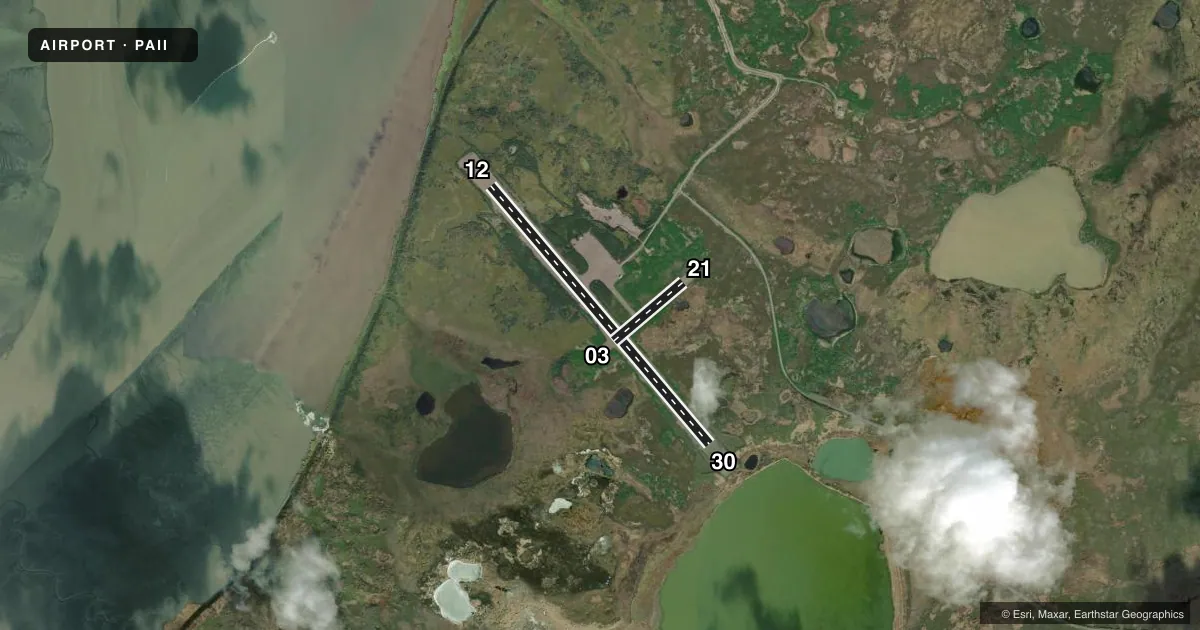
Airport sketch
Runways drawn to scale from FAA survey coordinates, rendered over satellite imagery. Not for navigation.
Approaches & charts
Services on the field
Fuel grades, oxygen, maintenance, ramp storage and lighting — as declared to the FAA by the airport operator.
Fuel & services
- Fuel
- Not available
Ramp & ground
- Transient storage
- Tie-down
- Lighting schedule
- SEE RMK
- Beacon schedule
- SEE RMK
- Beacon
- White / Green (civil land)(WG)
- Wind indicator
- Lighted
- Segmented circle
- Yes
Fuel & FBOs
Cheapest 100LL and Jet A on the field and nearby. Always confirm with the FBO before taxi.
Airport notes
Surface conditions, obstructions, local procedures, lighting outages and other notes published with each FAA cycle.
General notes
- WX CAMERA AVBL ON INTERNET AT HTTPS://WEATHERCAMS.FAA.GOV
- RAMP AND TWYS SOFT WHEN WET.
Lighting notes
- ACTVT ROTG BCN - CTAF.
- ACTVT REIL RWY 12; PAPI RWY 12; MIRL RWY 03/21 & 12/30 - CTAF.
Other notes
- 03/21RWY SURFACE SOFT AFTER RAINS. SAFETY AREAS BEYOND THLDS AND RWY EDGES VERY SOFT.
- 12/30RWY SURFACE SOFT WHEN WET. WATER PONDING AFTER RAIN. SAFETY AREAS BEYOND THLDS AND RWY EDGES VERY SOFT.
VFR map & nearby airports
VFR sectional. Tap any ICAO chip to open that airport.
Key facts · PAII
Answer card- ICAO
- PAII
- Name
- EGEGIK
- Location
- EGEGIK, ALASKA
- Elevation
- 92.3 ft MSL
- Traffic pattern altitude
- 1,092.3 ft MSL (1,000 AGL)
- Control tower
- Non-towered (use CTAF)
- Total runways
- 2
- Longest runway
- 12/30 · 5,600 ft
- Published ILS approaches
- 0
- Published frequencies
- 1
- Magnetic variation
- 13°
- Current flight rules
- VFR
- Current wind
- 230° at 4 kt
- Favored runway now
- RWY 21
Egegik Airport sits in Egegik, Alaska. The field elevation is 92.3 ft MSL. It has two runways. The longest is 12/30 at 5,600 ft. The airport is not towered. CTAF is 122.8.
No ILS approaches are published here. For pattern work, use the standard 1,000 ft AGL pattern for light piston aircraft unless local instructions say otherwise. Runway 12/30 is gravel. Runway 03/21 is gravel and dirt. The published remarks matter here. Both runways can get soft after rain. Water ponding can form on 12/30. The ramp and taxiways are also soft when wet. That is a real factor for braking and taxi planning.
Runway 12 has REILs and a PAPI. Medium intensity runway lights are published for both runways. The lighting and rotating beacon are activated by the CTAF. There are no on-field FBOs listed in the facts, so verify fuel and services with the airport operator or call the field on CTAF before arrival. For a first visit, pay close attention to wet field conditions and soft edges near the thresholds. Check the current FAA Chart Supplement for any updates before you go.