METAR & TAF PAPN
Current METAR
Observed 06:56Z
PAPN 280656Z AUTO RMK AO2 SLPNO PWINO FZRANO $
- Wind
- Calm
- Visibility
- —
- Temp / Dew
- —
- Altimeter
- —
- Clouds
- Clear
- Density alt
- —
- Ceiling
- Unlimited
- Rules
- VFR
Airport info & contacts
Manager on record, flight service, ARTCC, attendance schedule and pattern altitude — published by the FAA and refreshed every 28 days.
Location
- From city
- 0 NM NNE
- VFR sectional
- KODIAK
- ARTCC
- ZAN · ANCHORAGE
- NOTAM facility
- PNP (NOTAM-D)
Airport manager
- Name
- FLOYD WILSON
- Phone
- 907-246-3325
- Address
- PO BOX 65, KING SALMON AK 99613
Flight service · Hours
- FSS ENA
- KENAI907-283-72111-866-864-1737
- Attendance
- Unattended
Frequencies
Tap any row to copy the frequency to your clipboard.
Runways & pattern
Full pagePattern entry · RWY 07
LEFT TRAFFICRunway end performance
| End | TORA | TODA | ASDA | LDA | VGSI | Approach lights | Obstruction |
|---|---|---|---|---|---|---|---|
| 25 | — | — | — | — | PAPI 4-box left(3°) | — | — |
Declared distances in feet. TORA = takeoff run available, TODA = takeoff distance, ASDA = accelerate-stop, LDA = landing distance.
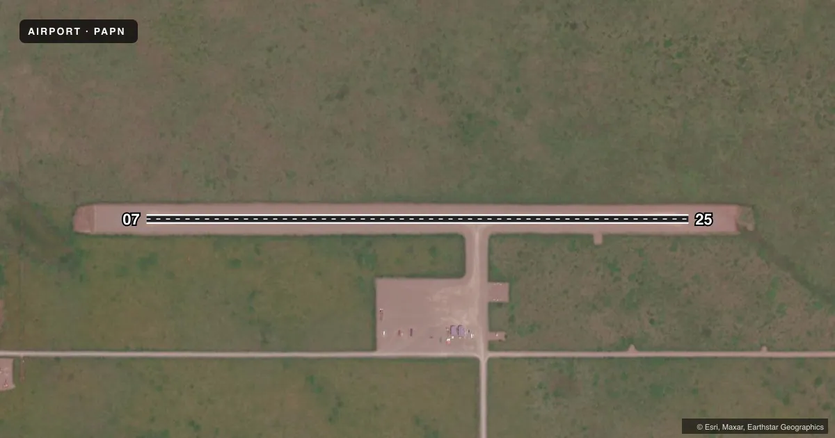
Airport sketch
Runways drawn to scale from FAA survey coordinates, rendered over satellite imagery. Not for navigation.
Approaches & charts
Services on the field
Fuel grades, oxygen, maintenance, ramp storage and lighting — as declared to the FAA by the airport operator.
Fuel & services
- Fuel
- Not available
Ramp & ground
- Transient storage
- Not published
- Lighting schedule
- SEE RMK
- Beacon schedule
- SS-SR
- Beacon
- White / Green (civil land)(WG)
- Wind indicator
- Lighted
- Segmented circle
- Yes
Fuel & FBOs
Cheapest 100LL and Jet A on the field and nearby. Always confirm with the FBO before taxi.
Airport notes
Surface conditions, obstructions, local procedures, lighting outages and other notes published with each FAA cycle.
General notes
- RWY CONDITIONS NOT MONITORED. RECOMMEND VISUAL INSPECTION PRIOR TO USE.
- WX CAMERA AVBL ON INTERNET AT HTTPS://WEATHERCAMS.FAA.GOV
Lighting notes
- ACTVT PAPI RWY 25; MIRL RWY 07/25 - CTAF.
Other notes
- FOR A TOLL FREE CALL TO KENAI FSS DIAL 1-866-864-1737.
VFR map & nearby airports
VFR sectional. Tap any ICAO chip to open that airport.
Key facts · PAPN
Answer card- ICAO
- PAPN
- Name
- PILOT POINT
- Location
- PILOT POINT, ALASKA
- Elevation
- 57 ft MSL
- Traffic pattern altitude
- 1,057 ft MSL (1,000 AGL)
- Control tower
- Non-towered (use CTAF)
- Total runways
- 1
- Longest runway
- 07/25 · 3,280 ft
- Published ILS approaches
- 0
- Published frequencies
- 1
- Magnetic variation
- 17°
- Current flight rules
- VFR
- Current wind
- Calm / unavailable
- Favored runway now
- –
Pilot Point Airport sits in Pilot Point, Alaska. The field elevation is 57 ft MSL. It has one runway. Runway 07/25 is 3,280 ft long and surfaced with gravel. This is an uncontrolled airport with no control tower. CTAF is 122.9.
No ILS approaches are published here. The published pattern altitude is not listed, so use the current Chart Supplement and local procedures before arrival. The runway headings are magnetic. Runway 07 is 90° magnetic. Runway 25 is 270° magnetic.
There are no on-field FBOs listed in the facts. Plan on self-sufficiency and verify services with the airport operator or the FBO directly by phone before you go. Published remarks say runway conditions are not monitored, so a visual inspection before use is a good idea. The field also has a PAPI for runway 25. Medium intensity runway lights for 07 and 25 are activated by CTAF. That is useful for night operations, but you should still confirm current lighting status before departure.
For current weather and operational details, use the current FAA Chart Supplement. The remarks also list a toll-free call to Kenai Flight Service Station at 1-866-864-1737. In this part of Alaska, weather and runway condition checks matter more than usual, especially with a gravel surface and no monitored runway condition reports.