METAR & TAF 9A8
9A8 does not publish a METAR.
Showing the nearest reporting station: PAPN (PILOT POINT) · 6.6 NM away. Conditions at 9A8 may differ.
METAR · PAPN
Observed 09:56Z
PAPN 280956Z AUTO RMK AO2 SLPNO PWINO FZRANO $
- Wind
- Calm
- Visibility
- —
- Temp / Dew
- —
- Altimeter
- —
- Clouds
- Clear
- Density alt
- —
- Ceiling
- Unlimited
- Rules
- VFR
Airport info & contacts
Manager on record, flight service, ARTCC, attendance schedule and pattern altitude — published by the FAA and refreshed every 28 days.
Location
- From city
- 1 NM N
- VFR sectional
- KODIAK
- ARTCC
- ZAN · ANCHORAGE
- NOTAM facility
- ENA (NOTAM-D)
Airport manager
- Name
- FLOYD WILSON
- Phone
- 907-246-3325
- Address
- BOX 65, KING SALMON AK 99613
Flight service · Hours
- FSS ENA
- KENAI907-283-72111-866-864-1737
- Attendance
- Unattended
Frequencies
Tap any row to copy the frequency to your clipboard.
Runways & pattern
Full pagePattern entry · RWY 06
LEFT TRAFFICRunway end performance
| End | TORA | TODA | ASDA | LDA | VGSI | Approach lights | Obstruction |
|---|---|---|---|---|---|---|---|
| 06 | — | — | — | — | — | — | 6', brush, 0' from thr, 96' R of cntrln, slope 0 |
| 24 | — | — | — | — | — | — | 7', brush, 0' from thr, 65' R of cntrln, slope 0 |
Declared distances in feet. TORA = takeoff run available, TODA = takeoff distance, ASDA = accelerate-stop, LDA = landing distance.
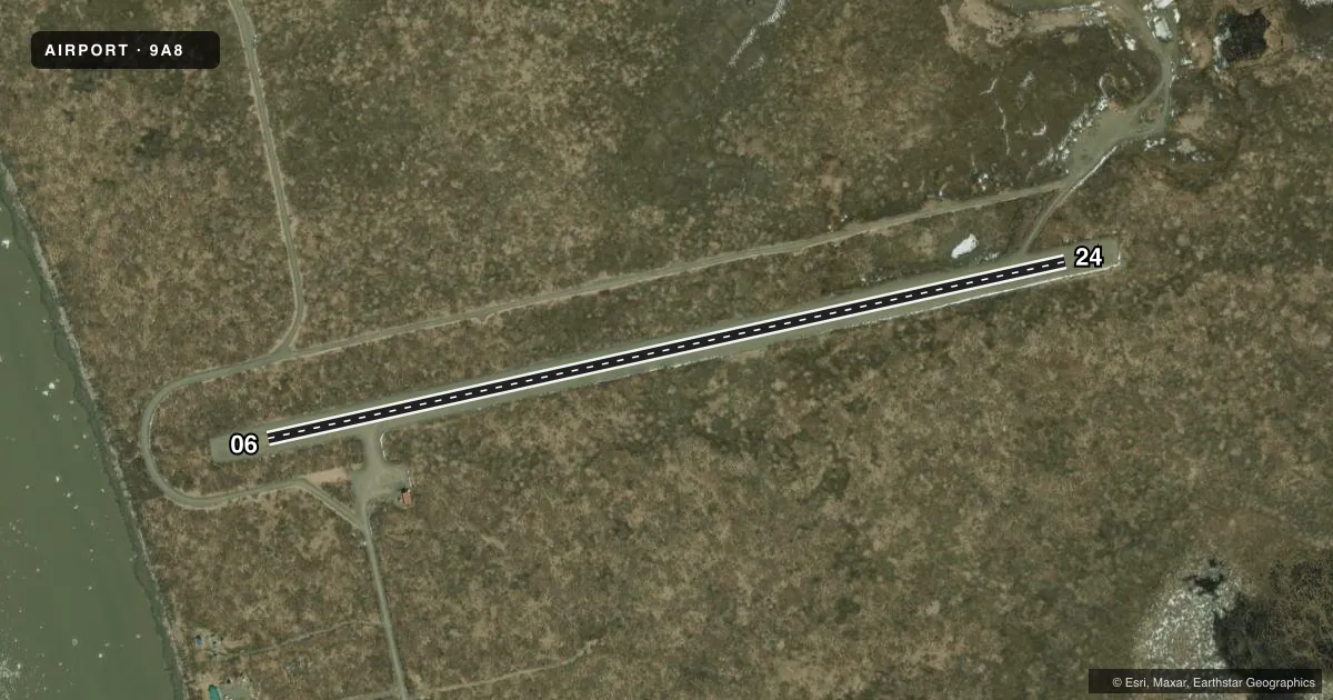
Airport sketch
Runways drawn to scale from FAA survey coordinates, rendered over satellite imagery. Not for navigation.
Approaches & charts
Services on the field
Fuel grades, oxygen, maintenance, ramp storage and lighting — as declared to the FAA by the airport operator.
Fuel & services
- Fuel
- Not available
Ramp & ground
- Transient storage
- Tie-down
- Wind indicator
- Yes
- Segmented circle
- No
Fuel & FBOs
Cheapest 100LL and Jet A on the field and nearby. Always confirm with the FBO before taxi.
Airport notes
Surface conditions, obstructions, local procedures, lighting outages and other notes published with each FAA cycle.
General notes
- RWY COND UNMNT; RCMD VISUAL INSP BFR LNDG.
- CTN: PVT RWY 2500 FT SSE.
Runway surface & condition
- 06/24BRUSH ALG BOTH SIDES & NEAR THRS.
Approach & departure obstructions
- 06REFLECTIVE ORANGE CONES & THR PANELS.
- 24REFLECTIVE ORANGE CONES & THR PANELS.
Other notes
- 06/24SOFT WHEN WET; WATER POND MID FLD 3 FT X 5 FT X 3 IN DEEP.
VFR map & nearby airports
VFR sectional. Tap any ICAO chip to open that airport.
Key facts · 9A8
Answer card- ICAO
- 9A8
- Name
- UGASHIK
- Location
- UGASHIK, ALASKA
- Elevation
- 43.8 ft MSL
- Traffic pattern altitude
- 1,043.8 ft MSL (1,000 AGL)
- Control tower
- Non-towered (use CTAF)
- Total runways
- 1
- Longest runway
- 06/24 · 3,100 ft
- Published ILS approaches
- 0
- Published frequencies
- 1
- Magnetic variation
- 20°
- Current flight rules
- VFR
- Current wind
- Calm / unavailable
- Favored runway now
- –
UGASHIK Airport sits in Ugashik, Alaska. Field elevation is 43.8 ft MSL. The airport has one runway. Runway 06/24 is 3,100 ft long and surfaced with gravel. There is no control tower. CTAF is 122.9. No ILS approaches are published here.
Pattern altitude is not published. Use the standard 1,000 ft AGL pattern unless the current Chart Supplement or local procedures say otherwise. That puts the light aircraft pattern at about 1,044 ft MSL based on field elevation. Verify before you fly.
Published remarks matter here. Reflective orange cones and threshold panels mark both runway ends. Brush is along both sides of the runway and near the thresholds. The runway can be soft when wet. Water also ponds mid-field. Runway condition is unmonitored, so a visual inspection before landing is a good idea. There is also a private runway 2,500 ft south-southeast of the field.
No on-field FBOs are listed. Plan on self-sufficiency and verify current services with the airport operator or the FBO directly by phone before arrival. In this part of Alaska, weather and surface condition can change fast. The gravel surface, soft spots and nearby brush deserve a careful arrival brief.