METAR & TAF PAJZ
Current METAR
Observed 10:56Z
PAJZ 281056Z AUTO 21008KT 9SM CLR 05/04 A3014 RMK AO2 SLP204 T00500044
- Wind
- 210° @ 8 kt
- Visibility
- 9 SM
- Temp / Dew
- 5°C / 4°C
- Altimeter
- 30.14 inHg
- Clouds
- CLR
- Density alt
- -1,136 ft
- Ceiling
- Unlimited
- Rules
- VFR
Airport info & contacts
Manager on record, flight service, ARTCC, attendance schedule and pattern altitude — published by the FAA and refreshed every 28 days.
Location
- From city
- 1 NM E
- VFR sectional
- KODIAK
- ARTCC
- ZAN · ANCHORAGE
- NOTAM facility
- JZZ (NOTAM-D)
Airport manager
- Name
- KEVIN HARDIN
- Phone
- 907-842-5511
- Address
- BOX 250, DILLINGHAM AK 99576
Flight service · Hours
- FSS DLG
- DILLINGHAM907-842-5275LC842-5275
- Attendance
- Unattended
Frequencies
Tap any row to copy the frequency to your clipboard.
Runways & pattern
Full pagePattern entry · RWY 27
LEFT TRAFFICRunway end performance
| End | TORA | TODA | ASDA | LDA | VGSI | Approach lights | Obstruction |
|---|---|---|---|---|---|---|---|
| 09 | 3,300' | 3,300' | 3,300' | 3,300' | PAPI 4-box right(3.5°) | — | 4', brush, 5' from thr, 217' R of cntrln, slope 1 |
| 27 | 3,300' | 3,300' | 3,300' | 3,300' | PAPI 4-box left(3.5°) | — | 6', brush, 0' from thr, 115' R of cntrln, slope 0 |
Declared distances in feet. TORA = takeoff run available, TODA = takeoff distance, ASDA = accelerate-stop, LDA = landing distance.
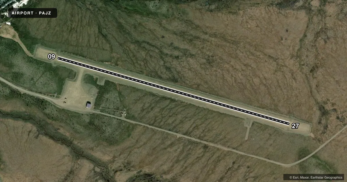
Airport sketch
Runways drawn to scale from FAA survey coordinates, rendered over satellite imagery. Not for navigation.
Approaches & charts
Services on the field
Fuel grades, oxygen, maintenance, ramp storage and lighting — as declared to the FAA by the airport operator.
Fuel & services
- Fuel
- Not available
Ramp & ground
- Transient storage
- Tie-down
- Lighting schedule
- SEE RMK
- Beacon schedule
- SEE RMK
- Beacon
- White / Green (civil land)(WG)
- Wind indicator
- Yes
- Segmented circle
- Yes
Fuel & FBOs
Cheapest 100LL and Jet A on the field and nearby. Always confirm with the FBO before taxi.
Airport notes
Surface conditions, obstructions, local procedures, lighting outages and other notes published with each FAA cycle.
General notes
- RWY COND UNMNT; RCMD VISUAL INSP PRIOR TO USE.
- WX CAMERA AVBL ON INTERNET AT HTTPS://WEATHERCAMS.FAA.GOV
Lighting notes
- ACTVT ROTG BCN - CTAF.
- ACTVT MIRL RWY 09/27; PAPI RWY 09 & 27 - CTAF.
Runway surface & condition
- 09/27SLOPES DOWN TOWARD W END.
Approach & departure obstructions
- 09THR MKD WITH LGTS.
- 27THR MKD WITH LGTS
Other notes
- 09/27HEAVES & HUMPS; RWY SLOUGHING OFF INTO TUNDRA.
VFR map & nearby airports
VFR sectional. Tap any ICAO chip to open that airport.
Key facts · PAJZ
Answer card- ICAO
- PAJZ
- Name
- KOLIGANEK
- Location
- KOLIGANEK, ALASKA
- Elevation
- 271.8 ft MSL
- Traffic pattern altitude
- 1,271.8 ft MSL (1,000 AGL)
- Control tower
- Non-towered (use CTAF)
- Total runways
- 1
- Longest runway
- 09/27 · 3,300 ft
- Published ILS approaches
- 0
- Published frequencies
- 1
- Magnetic variation
- 13°
- Current flight rules
- VFR
- Current wind
- 210° at 8 kt
- Favored runway now
- RWY 27
PAJZ is the airport at KOLIGANEK, Alaska. Field elevation is 271.8 ft MSL. It has one runway. Runway 09/27 is 3,300 ft long and gravel. The airport is non-towered. CTAF is 122.9.
No ILS approaches are published here. Pattern altitude is not published, so use the standard 1,000 ft AGL for light piston operations unless the current Chart Supplement says otherwise. The runway headings are 106° and 286° magnetic. That matters here because the field sits in Alaska and the runway is not paved.
Published remarks call out a few things a pilot should not skip. The runway condition is unmonitored, so look it over before landing. The surface has heaves and humps. It is also sloughing off into tundra. The runway slopes down toward the west end. Thresholds on both ends are marked with lights. Medium intensity runway lights are available on 09/27. The rotating beacon and the PAPI on both ends are activated by CTAF. There is also a weather camera online for a preflight look.
No on-field FBOs are listed. Check with the airport operator or the FBO directly by phone before arrival if you need fuel or other services.