METAR & TAF PFKK
PFKK does not publish a METAR.
Showing the nearest reporting station: PAIL (ILIAMNA) · 19.7 NM away. Conditions at PFKK may differ.
METAR · PAIL
Observed 11:53Z
PAIL 281153Z 24006KT 10SM SCT012 OVC060 08/07 A3013 RMK AO2 RAE1058 SLP205 P0000 60000 T00780067 10122 20078 51007
- Wind
- 240° @ 6 kt
- Visibility
- 10 SM
- Temp / Dew
- 8°C / 7°C
- Altimeter
- 30.13 inHg
- Clouds
- OVC
- Density alt
- -958 ft
- Ceiling
- 6,000 ft AGL
- Rules
- VFR
Airport info & contacts
Manager on record, flight service, ARTCC, attendance schedule and pattern altitude — published by the FAA and refreshed every 28 days.
Location
- From city
- 2 NM SW
- VFR sectional
- KODIAK
- ARTCC
- ZAN · ANCHORAGE
- NOTAM facility
- ILI (NOTAM-D)
Airport manager
- Name
- TREFIM ANDREW
- Phone
- 907-571-1261
- Address
- BOX 187, ILIAMNA AK 99606
Flight service · Hours
- FSS ILI
- ILIAMNA907-571-1240LC571-1240
- Attendance
- Unattended
Frequencies
Tap any row to copy the frequency to your clipboard.
Runways & pattern
Full pagePattern entry · RWY 25
LEFT TRAFFICRunway end performance
| End | TORA | TODA | ASDA | LDA | VGSI | Approach lights | Obstruction |
|---|---|---|---|---|---|---|---|
| 07 | — | — | — | — | PAPI 4-box left(3°) | — | 7', brush, 0' from thr, 102' R of cntrln, slope 0 |
| 25 | — | — | — | — | PAPI 4-box left(4°) | — | 8', brush, 0' from thr, 103' R of cntrln, slope 0 |
Declared distances in feet. TORA = takeoff run available, TODA = takeoff distance, ASDA = accelerate-stop, LDA = landing distance.
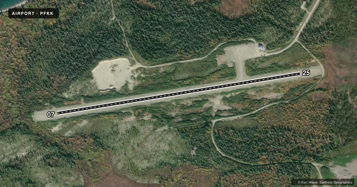
Airport sketch
Runways drawn to scale from FAA survey coordinates, rendered over satellite imagery. Not for navigation.
Approaches & charts
Services on the field
Fuel grades, oxygen, maintenance, ramp storage and lighting — as declared to the FAA by the airport operator.
Fuel & services
- Fuel
- Not available
Ramp & ground
- Transient storage
- Tie-down
- Lighting schedule
- SEE RMK
- Beacon schedule
- SEE RMK
- Beacon
- White / Green (civil land)(WG)
- Wind indicator
- Yes
- Segmented circle
- Yes
Fuel & FBOs
Cheapest 100LL and Jet A on the field and nearby. Always confirm with the FBO before taxi.
Airport notes
Surface conditions, obstructions, local procedures, lighting outages and other notes published with each FAA cycle.
General notes
- RWY UNMNT; RCMD VISUAL INSP BFR USE.
- WX CAMERA AVBL ON INTERNET AT HTTPS://WEATHERCAMS.FAA.GOV
- HORSES ON OR INVOF RWY.
Lighting notes
- ACTVT ROTG BCN - CTAF.
- ACTVT REIL RWY 07 & 25; PAPI RWY 07 & 25; MIRL RWY 07/25; WINDCONE - CTAF.
Runway surface & condition
- 07/2530 FT UNLGTD TWR 300 FT N.
VFR map & nearby airports
VFR sectional. Tap any ICAO chip to open that airport.
Key facts · PFKK
Answer card- ICAO
- PFKK
- Name
- KOKHANOK
- Location
- KOKHANOK, ALASKA
- Elevation
- 114.7 ft MSL
- Traffic pattern altitude
- 1,114.7 ft MSL (1,000 AGL)
- Control tower
- Non-towered (use CTAF)
- Total runways
- 1
- Longest runway
- 07/25 · 3,300 ft
- Published ILS approaches
- 0
- Published frequencies
- 1
- Magnetic variation
- 14°
- Current flight rules
- VFR
- Current wind
- 240° at 6 kt
- Favored runway now
- RWY 25
PFKK serves Kokhanok in Alaska. The field elevation is 114.7 ft MSL. It has one runway. Runway 07/25 is 3,300 ft of gravel. The runway headings are 81° and 261° magnetic. There is no control tower. CTAF is 122.9.
No ILS approaches are published here. Pattern altitude is not published, so a light piston pilot would normally plan for 1,000 ft AGL unless current local guidance says otherwise. That puts the usual pattern about 1,115 ft MSL based on the field elevation. Check the current FAA Chart Supplement before you go if you want the latest pattern or airport notes.
The published remarks matter here. Runway 07 and 25 have REILs, PAPI and medium intensity runway lights. The rotating beacon is activated on CTAF. The runway is unmaintained, so a preflight visual check is a good idea. A 30-foot unlighted tower sits 300 feet north of the runway. Horses may be on or near the runway. There is no on-field FBO listed, so plan to verify services with the airport operator or the FBO directly by phone before arrival. For weather, the FAA lists an internet camera for the field. Alaska weather, gravel surface conditions and wildlife all deserve a close look before you launch.