METAR & TAF PANO
PANO does not publish a METAR.
Showing the nearest reporting station: PAIL (ILIAMNA) · 13.7 NM away. Conditions at PANO may differ.
METAR · PAIL
Observed 02:53Z
PAIL 280253Z 23009G21KT 10SM FEW029 OVC085 14/08 A3003 RMK AO2 SLP169 T01440078 53000
- Wind
- 230° @ 9G21 kt
- Visibility
- 10 SM
- Temp / Dew
- 14°C / 8°C
- Altimeter
- 30.03 inHg
- Clouds
- OVC
- Density alt
- 133 ft
- Ceiling
- 8,500 ft AGL
- Rules
- VFR
Airport info & contacts
Manager on record, flight service, ARTCC, attendance schedule and pattern altitude — published by the FAA and refreshed every 28 days.
Location
- From city
- 1 NM NNE
- VFR sectional
- KODIAK
- ARTCC
- ZAN · ANCHORAGE
- NOTAM facility
- ILI (NOTAM-D)
Airport manager
- Name
- TREFIM ANDREW
- Phone
- 907-571-1261
- Address
- PO BOX 187, ILIAMMA 99606
Flight service · Hours
- FSS ILI
- ILIAMNA907-571-1240LC571-1240
- Attendance
- Unattended
Frequencies
Tap any row to copy the frequency to your clipboard.
Runways & pattern
Full pagePattern entry · RWY 20
LEFT TRAFFICRunway end performance
| End | TORA | TODA | ASDA | LDA | VGSI | Approach lights | Obstruction |
|---|---|---|---|---|---|---|---|
| 02 | — | — | — | — | PAPI 4-box left(3.5°) | — | 18', brush, 0' from thr, 248' R of cntrln, slope 0 |
| 20 | — | — | — | — | PAPI 4-box left(3.5°) | — | 5', brush, 0' from thr, 95' R of cntrln, slope 0 |
Declared distances in feet. TORA = takeoff run available, TODA = takeoff distance, ASDA = accelerate-stop, LDA = landing distance.
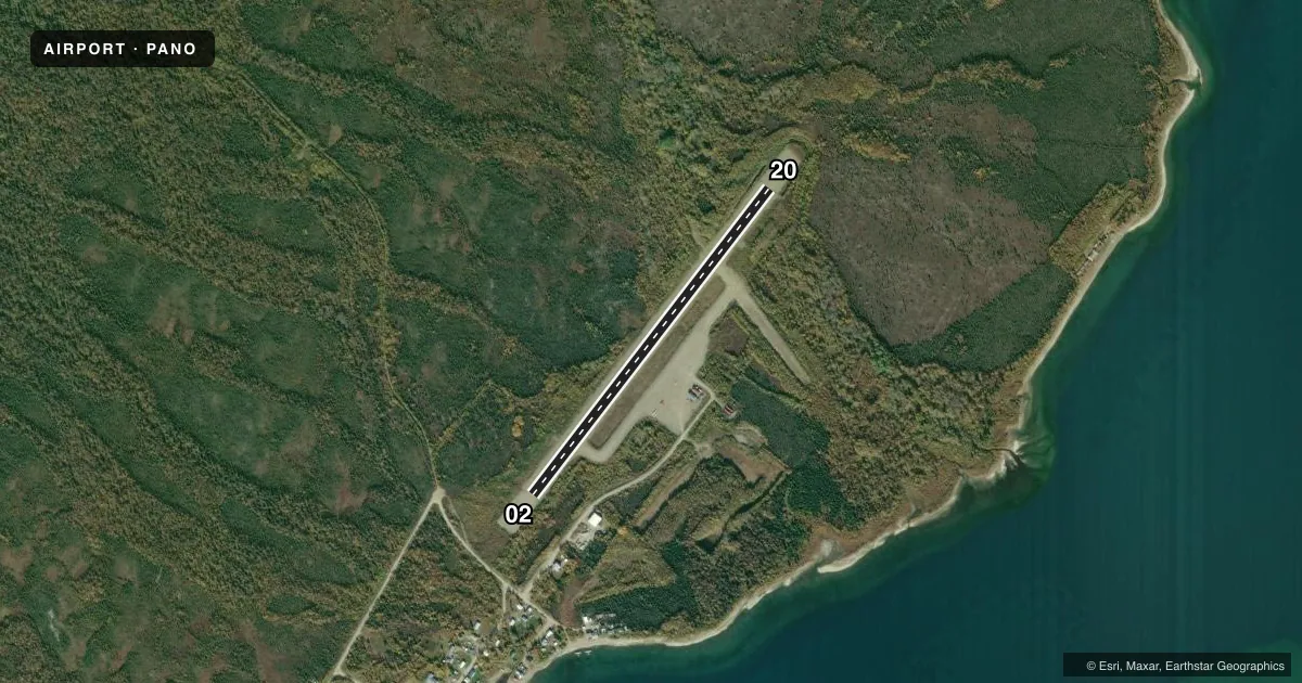
Airport sketch
Runways drawn to scale from FAA survey coordinates, rendered over satellite imagery. Not for navigation.
Approaches & charts
Services on the field
Fuel grades, oxygen, maintenance, ramp storage and lighting — as declared to the FAA by the airport operator.
Fuel & services
- Fuel
- Not available
- Other services
- CARGO
Ramp & ground
- Transient storage
- Tie-down
- Landing fee
- No fee published
- Customs
- Not available
- Lighting schedule
- SEE RMK
- Beacon schedule
- SEE RMK
- Beacon
- White / Green (civil land)(WG)
- Wind indicator
- Lighted
- Segmented circle
- Yes
Fuel & FBOs
Cheapest 100LL and Jet A on the field and nearby. Always confirm with the FBO before taxi.
Airport notes
Surface conditions, obstructions, local procedures, lighting outages and other notes published with each FAA cycle.
General notes
- RWY COND UNMNT; RCMD VISUAL INSP BFR USE.
- WX CAMERA AVBL ON INTERNET AT HTTPS://WEATHERCAMS.FAA.GOV
- COLD TEMPERATURE AIRPORT. ALTITUDE CORRECTION REQUIRED AT OR BELOW -29C.
Lighting notes
- ACTVT ROTG BCN - CTAF.
- ACTVT REIL RWY 02 & 20; PAPI RWY 02 & 20; MIRL RWY 02/20; WINDSOCK LGT - CTAF.
Runway surface & condition
- 02/20EXP STRONG VRBL XWINDS AT OR NEAR SFC. 55 FT WATER TANK & 45 FT TWR 2030-2130 FT FM RWY 20 DEP END 395-420 FT R OF CNTRLN.
- 02/20WHITE FULL LEN.
Approach & departure obstructions
- 02EDGE REFLECTIVE CONES; THR REFLECTIVE CONES & PANELS.
- 20EDGE REFLECTIVE CONES; THR REFLECTIVE CONES & PANELS.
- 02PAPI UNUSBL BYD 4 DEG LEFT OF CNTRLN.
VFR map & nearby airports
VFR sectional. Tap any ICAO chip to open that airport.
Key facts · PANO
Answer card- ICAO
- PANO
- Name
- NONDALTON
- Location
- NONDALTON, ALASKA
- Elevation
- 314 ft MSL
- Traffic pattern altitude
- 1,314 ft MSL (1,000 AGL)
- Control tower
- Non-towered (use CTAF)
- Total runways
- 1
- Longest runway
- 02/20 · 2,800 ft
- Published ILS approaches
- 0
- Published frequencies
- 1
- Magnetic variation
- 14°
- Current flight rules
- VFR
- Current wind
- 230° at 9 kt
- Favored runway now
- RWY 20
PANO is the airport for Nondalton, Alaska. The field elevation is 314 ft MSL. It has one runway, 02/20, which is 2,800 ft long and gravel. There is no control tower. CTAF is 122.9.
No ILS approaches are published here. Pattern altitude is not published, so use the standard 1,000 ft AGL for light piston ops unless the current Chart Supplement says otherwise. That puts the pattern at 1,314 ft MSL based on the field elevation. This is a cold temperature airport. Altitude correction is required at or below minus 29 degrees Celsius. Runway condition is unmonitored, so a visual check before use makes sense here.
Published remarks also note strong variable crosswinds at or near the surface. Runway 02/20 has medium intensity lights, white lighting along the full length, PAPI, runway end identifier lights and windsock lighting keyed to CTAF. Runway 20 has a water tank and tower near the departure end. Runway 02 has reflective cones and threshold panels. There are no on-field FBOs listed. Plan on coordinating directly with the airport operator or checking current field services before arrival.