METAR & TAF PACK
PACK does not publish a METAR.
Showing the nearest reporting station: PAKI (KIPNUK) · 14.4 NM away. Conditions at PACK may differ.
METAR · PAKI
Observed 12:27Z
PAKI 281227Z AUTO 15011KT 10SM -RA OVC027 09/07 A3000 RMK AO2 RAB07
- Wind
- 150° @ 11 kt
- Visibility
- 10 SM
- Temp / Dew
- 9°C / 7°C
- Altimeter
- 30.00 inHg
- Clouds
- OVC
- Density alt
- -752 ft
- Ceiling
- 2,700 ft AGL
- Rules
- MVFR
Airport info & contacts
Manager on record, flight service, ARTCC, attendance schedule and pattern altitude — published by the FAA and refreshed every 28 days.
Location
- From city
- 1 NM S
- VFR sectional
- BETHEL
- ARTCC
- ZAN · ANCHORAGE
- NOTAM facility
- ENA (NOTAM-D)
Airport manager
- Name
- JOSEPH LARAUX
- Phone
- 907-543-2495
- Address
- BOX 505, BETHEL AK 99559
Flight service · Hours
- FSS ENA
- KENAI907-283-72111-866-864-1737
- Attendance
- Unattended
Frequencies
Tap any row to copy the frequency to your clipboard.
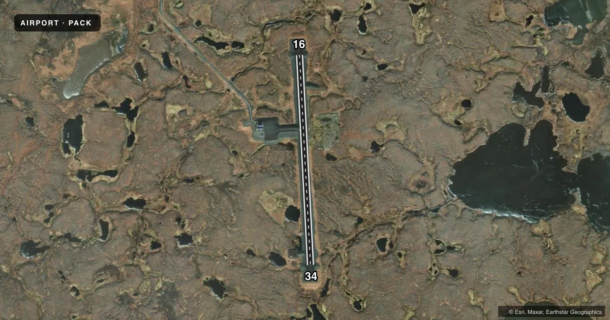
Runways & pattern
Full pagePattern entry · RWY 16
LEFT TRAFFICAirport sketch
Runways drawn to scale from FAA survey coordinates, rendered over satellite imagery. Not for navigation.
Approaches & charts
Services on the field
Fuel grades, oxygen, maintenance, ramp storage and lighting — as declared to the FAA by the airport operator.
Fuel & services
- Fuel
- Not available
Ramp & ground
- Transient storage
- Not published
- Lighting schedule
- SEE RMK
- Beacon schedule
- SEE RMK
- Beacon
- White / Green (civil land)(WG)
- Wind indicator
- Lighted
- Segmented circle
- Yes
Fuel & FBOs
Cheapest 100LL and Jet A on the field and nearby. Always confirm with the FBO before taxi.
Airport notes
Surface conditions, obstructions, local procedures, lighting outages and other notes published with each FAA cycle.
General notes
- RWY COND UNMNT; RCMD VISUAL INSP BFR USE.
- WX CAMERAS AVBL ON INTERNET AT HTTPS://WEATHERCAMS.FAA.GOV
- ANNOUNCE ON CTAF 10 NM ON APCH & BFR LNDG.
- BIRDS ON & INVOF ARPT.
Lighting notes
- ACTVT BEACON - CTAF.
- ACTVT MIRL RWY 16/34 - CTAF.
Approach & departure obstructions
- 16CONES.
- 34CONES.
Other notes
- 16/34SOFT WHEN WET. 6-8 IN DIPS IREG SFC FULL LEN.
VFR map & nearby airports
VFR sectional. Tap any ICAO chip to open that airport.
Key facts · PACK
Answer card- ICAO
- PACK
- Name
- CHEFORNAK
- Location
- CHEFORNAK, ALASKA
- Elevation
- 53.9 ft MSL
- Traffic pattern altitude
- 1,053.9 ft MSL (1,000 AGL)
- Control tower
- Non-towered (use CTAF)
- Total runways
- 1
- Longest runway
- 16/34 · 3,230 ft
- Published ILS approaches
- 0
- Published frequencies
- 1
- Magnetic variation
- –
- Current flight rules
- MVFR
- Current wind
- 150° at 11 kt
- Favored runway now
- RWY 16
Chefornak Airport sits in Chefornak, Alaska. Field elevation is 54.1 ft MSL. The airport has one runway. Runway 16/34 is 3,230 ft long and gravel. There is no control tower. CTAF is 122.7. No ILS approaches are published here.
Pattern altitude is not published. Use the standard 1,000 ft AGL for light piston operations unless the current Chart Supplement says otherwise. The published runway headings are 177° and 357° magnetic. The runway is edged with cones and lights on both ends. The beacon and the medium intensity runway lights are activated using the CTAF.
There are no on-field FBOs listed. Check with the airport operator or the field directly before arrival for any services. Published remarks also say runway condition is not monitored. A visual inspection is recommended before use. The runway may be soft when wet. There are 6 to 8 inch dips and irregular surfaces along the full length of the runway. Birds are reported on or near the airport, so keep a sharp scan on final and in the pattern. Pilots should self-announce on CTAF about 10 NM out. Weather cameras are available online for a current look before you launch.