METAR & TAF PADY
PADY does not publish a METAR.
Showing the nearest reporting station: PAQH (QUINHAGAK) · 33.6 NM away. Conditions at PADY may differ.
METAR · PAQH
Observed 08:22Z
PAQH 280822Z AUTO 19009KT 10SM SCT016 OVC034 09/07 A3008 RMK AO2 RAB05E16 P0000
- Wind
- 190° @ 9 kt
- Visibility
- 10 SM
- Temp / Dew
- 9°C / 7°C
- Altimeter
- 30.08 inHg
- Clouds
- OVC
- Density alt
- -869 ft
- Ceiling
- 3,400 ft AGL
- Rules
- VFR
Airport info & contacts
Manager on record, flight service, ARTCC, attendance schedule and pattern altitude — published by the FAA and refreshed every 28 days.
Location
- From city
- 1 NM NE
- VFR sectional
- BETHEL
- ARTCC
- ZAN · ANCHORAGE
- NOTAM facility
- ENA (NOTAM-D)
Airport manager
- Name
- JOSEPH LARAUX
- Phone
- (907) 543-2498
- Address
- PO BOX 505, BETHEL AK 99559
Flight service · Hours
- FSS ENA
- KENAI907-283-72111-866-864-1737
- Attendance
- Unattended
Frequencies
Tap any row to copy the frequency to your clipboard.
Runways & pattern
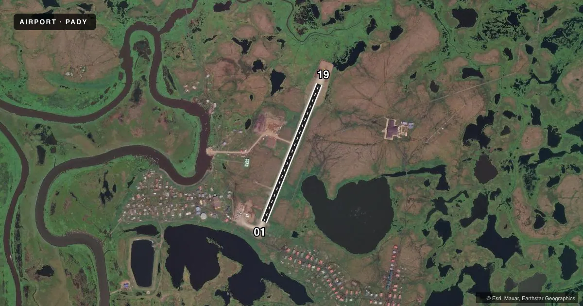
Full pagePattern entry · RWY 19
LEFT TRAFFICAirport sketch
Runways drawn to scale from FAA survey coordinates, rendered over satellite imagery. Not for navigation.
Approaches & charts
Services on the field
Fuel grades, oxygen, maintenance, ramp storage and lighting — as declared to the FAA by the airport operator.
Fuel & services
- Fuel
- Not available
Ramp & ground
- Transient storage
- Not published
- Landing fee
- No fee published
- Customs
- Not available
- Lighting schedule
- SEE RMK
- Beacon schedule
- SEE RMK
- Beacon
- White / Green (civil land)(WG)
- Wind indicator
- Lighted
- Segmented circle
- Yes
Fuel & FBOs
Cheapest 100LL and Jet A on the field and nearby. Always confirm with the FBO before taxi.
Airport notes
Surface conditions, obstructions, local procedures, lighting outages and other notes published with each FAA cycle.
General notes
- RWY COND UNMNT; RCMD VISUAL INSP BFR USE.
- WILDLIFE INVOF RWY.
- ALERT: 235 FT TWR E; WIND GENERATORS E.
Lighting notes
- ACTVT ROTG BCN - CTAF.
- ACTVT MIRL RWY 01/19 - CTAF.
Other notes
- 01/19S 500 FT IREG SFC VARNS & PONDING.
VFR map & nearby airports
VFR sectional. Tap any ICAO chip to open that airport.
Key facts · PADY
Answer card- ICAO
- PADY
- Name
- KONGIGANAK
- Location
- KONGIGANAK, ALASKA
- Elevation
- 39.6 ft MSL
- Traffic pattern altitude
- 1,039.6 ft MSL (1,000 AGL)
- Control tower
- Non-towered (use CTAF)
- Total runways
- 1
- Longest runway
- 01/19 · 2,400 ft
- Published ILS approaches
- 0
- Published frequencies
- 1
- Magnetic variation
- 18°
- Current flight rules
- VFR
- Current wind
- 190° at 9 kt
- Favored runway now
- RWY 19
PADY is the airport at Kongiganak, Alaska. Field elevation is 39.6 ft MSL. It has one runway, 01/19, which is 2,400 ft long and surfaced with gravel and dirt. There is no control tower. CTAF is 122.7.
No ILS approaches are published here. Pattern altitude is not published, so use standard 1,000 ft AGL for light piston operations unless the current Chart Supplement says otherwise. That puts the pattern at about 1,040 ft MSL based on the field elevation. Verify before you fly.
The published remarks matter here. Wildlife is in the vicinity of the runway. The runway surface has 500 feet of irregular surface with varnishes and ponding. Runway condition is unmonitored, so a visual inspection before use is a smart call. There is also a 235 ft tower east of the field plus wind generators east of the airport. Medium intensity runway lights on 01/19 are activated on the CTAF. The rotating beacon is also activated on the CTAF.
There are no on-field FBOs listed. For current services or fuel availability, contact the airport operator directly or call the field on CTAF before arrival. This is a small, uncontrolled Alaska field with a short gravel-dirt runway. Plan for surface condition, wildlife and local weather before committing.