METAR & TAF PAEE
PAEE does not publish a METAR.
Showing the nearest reporting station: PAQH (QUINHAGAK) · 28.2 NM away. Conditions at PAEE may differ.
METAR · PAQH
Observed 08:22Z
PAQH 280822Z AUTO 19009KT 10SM SCT016 OVC034 09/07 A3008 RMK AO2 RAB05E16 P0000
- Wind
- 190° @ 9 kt
- Visibility
- 10 SM
- Temp / Dew
- 9°C / 7°C
- Altimeter
- 30.08 inHg
- Clouds
- OVC
- Density alt
- -886 ft
- Ceiling
- 3,400 ft AGL
- Rules
- VFR
Airport info & contacts
Manager on record, flight service, ARTCC, attendance schedule and pattern altitude — published by the FAA and refreshed every 28 days.
Location
- From city
- 1 NM W
- VFR sectional
- BETHEL
- ARTCC
- ZAN · ANCHORAGE
- NOTAM facility
- ENA (NOTAM-D)
Airport manager
- Name
- JOSEPH LARAUX
- Phone
- (907) 543-2498
- Address
- BOX 505, BETHEL AK 99559
Flight service · Hours
- FSS ENA
- KENAI907-283-72111-866-864-1737
- Attendance
- Unattended
Frequencies
Tap any row to copy the frequency to your clipboard.
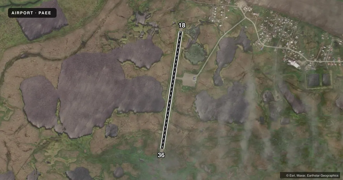
Runways & pattern
Full pagePattern entry · RWY 18
LEFT TRAFFICRunway end performance
| End | TORA | TODA | ASDA | LDA | VGSI | Approach lights | Obstruction |
|---|---|---|---|---|---|---|---|
| 18 | — | — | — | — | PAPI 4-box left(3°) | — | 3', brush, 8' from thr, 58' R of cntrln, slope 2 |
| 36 | — | — | — | — | PAPI 4-box left(3°) | — | 5', brush, 10' from thr, 60' R of cntrln, slope 2 |
Declared distances in feet. TORA = takeoff run available, TODA = takeoff distance, ASDA = accelerate-stop, LDA = landing distance.
Airport sketch
Runways drawn to scale from FAA survey coordinates, rendered over satellite imagery. Not for navigation.
Approaches & charts
Services on the field
Fuel grades, oxygen, maintenance, ramp storage and lighting — as declared to the FAA by the airport operator.
Fuel & services
- Fuel
- Not available
- Oxygen (bottled)
- Not available
- Oxygen (bulk)
- Not available
- Airframe repair
- Not available
- Power plant repair
- Not available
Ramp & ground
- Transient storage
- Not published
- Landing fee
- No fee published
- Customs
- Not available
- Lighting schedule
- SEE RMK
- Beacon schedule
- SS-SR
- Beacon
- White / Green (civil land)(WG)
- Wind indicator
- Lighted
- Segmented circle
- Yes
Fuel & FBOs
Cheapest 100LL and Jet A on the field and nearby. Always confirm with the FBO before taxi.
Airport notes
Surface conditions, obstructions, local procedures, lighting outages and other notes published with each FAA cycle.
General notes
- RWY CONDITION NOT MONITORED; RECOMMEND VISUAL INSPECTION PRIOR TO USING.
- WX CAMERA AVBL ON INTERNET AT HTTPS://WEATHERCAMS.FAA.GOV
- BIRDS INVOF ARPT.
- 300 FT TOWER APPX 1.1 MILES EAST OF ARPT.
- 6-8 IN DIPS IN RWY FULL LENGTH.
Lighting notes
- ACTVT REIL RWY 18, 36; PAPI RWY 18, 36; MIRL RWY 18/36 - CTAF.
Runway surface & condition
- 18/36GRASS AND BRUSH SURROUNDS RWY LGTS.
VFR map & nearby airports
VFR sectional. Tap any ICAO chip to open that airport.
Key facts · PAEE
Answer card- ICAO
- PAEE
- Name
- EEK
- Location
- EEK, ALASKA
- Elevation
- 26.5 ft MSL
- Traffic pattern altitude
- 1,026.5 ft MSL (1,000 AGL)
- Control tower
- Non-towered (use CTAF)
- Total runways
- 1
- Longest runway
- 18/36 · 3,242 ft
- Published ILS approaches
- 0
- Published frequencies
- 1
- Magnetic variation
- 11°
- Current flight rules
- VFR
- Current wind
- 190° at 9 kt
- Favored runway now
- RWY 18
Eek Airport sits in Eek, Alaska. The field elevation is 26.5 ft MSL. It has one runway. Runway 18/36 is 3,242 ft long and gravel. There is no control tower. CTAF is 122.8. No ILS approaches are published here.
Pattern altitude is not published. Use standard 1,000 ft AGL for light piston operations unless local guidance says otherwise. That puts the traffic pattern at about 1,026.5 ft MSL based on the field elevation. Verify local practice before you fly it. The runway has 6 to 8 inch dips along its full length. Runway condition is not monitored. A visual inspection before landing makes sense here. Birds are in the vicinity of the airport. A 300-foot tower sits about 1.1 miles east of the field.
Lighting is installed on runway 18/36. Runway end identifier lights are active on both ends. Precision approach path indicators are installed on both ends. Medium intensity runway lights are controlled by CTAF. No on-field FBOs are listed. Check the current FAA Chart Supplement or call the airport operator directly for any updates before arrival. In this part of Alaska, soft surface performance, runway condition and local weather deserve close attention before you commit to the landing.