METAR & TAF PAQH
Current METAR
Observed 17:17Z
PAQH 281717Z AUTO 18017KT 3SM -RA BR FEW004 OVC009 08/08 A3007 RMK AO2 CIG 007V012 P0000
- Wind
- 180° @ 17 kt
- Visibility
- 3 SM
- Temp / Dew
- 8°C / 8°C
- Altimeter
- 30.07 inHg
- Clouds
- OVC
- Density alt
- -972 ft
- Ceiling
- 900 ft AGL
- Rules
- IFR
Airport info & contacts
Manager on record, flight service, ARTCC, attendance schedule and pattern altitude — published by the FAA and refreshed every 28 days.
Location
- From city
- 2 NM E
- VFR sectional
- KODIAK
- ARTCC
- ZAN · ANCHORAGE
- NOTAM facility
- AQH (NOTAM-D)
Airport manager
- Name
- TIM DEBILT
- Phone
- 907-556-2375
- Address
- PO BOX 149, QUINHAGAK AK 99655
Flight service · Hours
- FSS ENA
- KENAI907-283-72111-866-864-1737
- Attendance
- Unattended
Frequencies
Tap any row to copy the frequency to your clipboard.
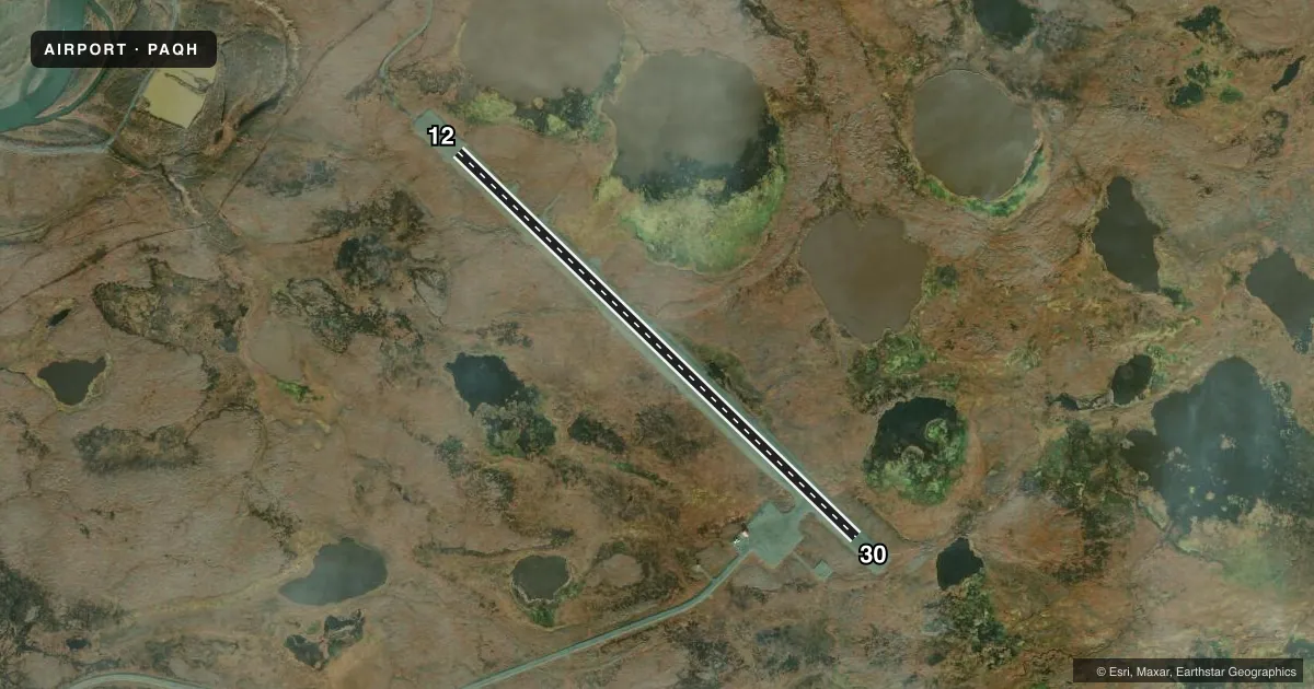
Runways & pattern
Full pagePattern entry · RWY 12
LEFT TRAFFICAirport sketch
Runways drawn to scale from FAA survey coordinates, rendered over satellite imagery. Not for navigation.
Approaches & charts
Services on the field
Fuel grades, oxygen, maintenance, ramp storage and lighting — as declared to the FAA by the airport operator.
Fuel & services
- Fuel
- Not available
Ramp & ground
- Transient storage
- Tie-down
- Landing fee
- Yes
- Customs
- Not available
- Lighting schedule
- SEE RMK
- Beacon schedule
- SEE RMK
- Beacon
- White / Green (civil land)(WG)
- Wind indicator
- Lighted
- Segmented circle
- Yes
Fuel & FBOs
Cheapest 100LL and Jet A on the field and nearby. Always confirm with the FBO before taxi.
Airport notes
Surface conditions, obstructions, local procedures, lighting outages and other notes published with each FAA cycle.
General notes
- FOR LNDG FEE - 907-556-2375.
- WX CAMERA AVBL HTTPS://WEATHERCAMS.FAA.GOV.
Lighting notes
- ACTVT ROTATING BEACON - CTAF.
- ACTVT MIRL RWY 12/30 - CTAF.
Approach & departure obstructions
- 12OTHER, MARKING TYPE.
- 30OTHER, MARKING TYPE.
Other notes
- 12/30LG SWELLS ACRS RWY & EXTDG ALG MAJORITY OF RWY LEN; HEAVES & DIPS ENTIRE LEN.
VFR map & nearby airports
VFR sectional. Tap any ICAO chip to open that airport.
Key facts · PAQH
Answer card- ICAO
- PAQH
- Name
- QUINHAGAK
- Location
- QUINHAGAK, ALASKA
- Elevation
- 43.2 ft MSL
- Traffic pattern altitude
- 1,043.2 ft MSL (1,000 AGL)
- Control tower
- Non-towered (use CTAF)
- Total runways
- 1
- Longest runway
- 12/30 · 4,000 ft
- Published ILS approaches
- 0
- Published frequencies
- 2
- Magnetic variation
- 11°
- Current flight rules
- IFR
- Current wind
- 180° at 17 kt
- Favored runway now
- RWY 12
Quinhagak Airport sits in Quinhagak, Alaska. Field elevation is 43.2 ft MSL. The airport has one runway. Runway 12/30 is 4,000 ft long and gravel. No tower is published here. CTAF and UNICOM are both 122.8.
No ILS approaches are published. Pattern altitude is not published, so use the standard 1,000 ft AGL for light piston operations unless the current Chart Supplement says otherwise. The published runway headings are 134° magnetic for 12 and 314° magnetic for 30. The rotating beacon is activated on CTAF. Medium intensity runway lights on 12/30 are also activated on CTAF.
There are no on-field FBOs listed. Check with the airport operator or the field directly before arrival for current services. The Chart Supplement remarks also note large swells across the runway and heaves and dips along much of its length. That matters here. Plan for a rough surface and stay alert during rollout and takeoff. Runway 12 and runway 30 also have other marking types published, so verify the runway markings before you go in.