METAR & TAF PAGG
PAGG does not publish a METAR.
Showing the nearest reporting station: PAKI (KIPNUK) · 26.1 NM away. Conditions at PAGG may differ.
METAR · PAKI
Observed 15:56Z
PAKI 281556Z AUTO 20013KT 10SM -RA FEW012 BKN025 OVC035 08/07 A2998 RMK AO2 SLPNO P0000 T00830072
- Wind
- 200° @ 13 kt
- Visibility
- 10 SM
- Temp / Dew
- 8°C / 7°C
- Altimeter
- 29.98 inHg
- Clouds
- OVC
- Density alt
- -888 ft
- Ceiling
- 2,500 ft AGL
- Rules
- MVFR
Airport info & contacts
Manager on record, flight service, ARTCC, attendance schedule and pattern altitude — published by the FAA and refreshed every 28 days.
Location
- From city
- 0 NM S
- VFR sectional
- BETHEL
- ARTCC
- ZAN · ANCHORAGE
- NOTAM facility
- ENA (NOTAM-D)
Airport manager
- Name
- JOSEPH LARAUX
- Phone
- 907-543-2498
- Address
- BOX 505, BETHEL AK 99559
Flight service · Hours
- FSS ENA
- KENAI907-283-72111-866-864-1737
- Attendance
- Unattended
Frequencies
Tap any row to copy the frequency to your clipboard.
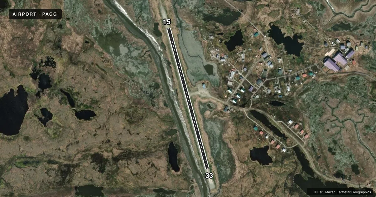
Runways & pattern
Full pagePattern entry · RWY 15
LEFT TRAFFICAirport sketch
Runways drawn to scale from FAA survey coordinates, rendered over satellite imagery. Not for navigation.
Approaches & charts
Services on the field
Fuel grades, oxygen, maintenance, ramp storage and lighting — as declared to the FAA by the airport operator.
Fuel & services
- Fuel
- Not available
Ramp & ground
- Transient storage
- Not published
- Landing fee
- No fee published
- Customs
- Not available
- Wind indicator
- Yes
- Segmented circle
- No
Fuel & FBOs
Cheapest 100LL and Jet A on the field and nearby. Always confirm with the FBO before taxi.
Airport notes
Surface conditions, obstructions, local procedures, lighting outages and other notes published with each FAA cycle.
General notes
- SAFETY AREAS NARROW, UNEVEN & UNDULATES.
- RWY COND UNMNT; RCMD VISUAL INSP PRIOR TO USE.
- PORTABLE RWY LGTS AVBL FOR EMERG USE - CTC VILLAGE POLICE SAFETY OFCR.
- WX CAMERA AVBL ON INTERNET AT HTTPS://WEATHERCAMS.FAA.GOV
- WATERFOWL INVOF ARPT.
- MULT WIND TURBINE TWRS E.
Runway surface & condition
- 15/331 PCT UPSLOPE TO S.
Approach & departure obstructions
- 15MKD WITH CONES.
- 33MKD WITH CONES.
Other notes
- UNREL.
- 15/33RWY USED AS ROAD; HOLES & DIPS IN RWY & RAMP.
VFR map & nearby airports
VFR sectional. Tap any ICAO chip to open that airport.
Key facts · PAGG
Answer card- ICAO
- PAGG
- Name
- KWIGILLINGOK
- Location
- KWIGILLINGOK, ALASKA
- Elevation
- 21.4 ft MSL
- Traffic pattern altitude
- 1,021.4 ft MSL (1,000 AGL)
- Control tower
- Non-towered (use CTAF)
- Total runways
- 1
- Longest runway
- 15/33 · 1,835 ft
- Published ILS approaches
- 0
- Published frequencies
- 1
- Magnetic variation
- 14°
- Current flight rules
- MVFR
- Current wind
- 200° at 13 kt
- Favored runway now
- RWY 15
Kwigillingok Airport (PAGG) sits in Kwigillingok, Alaska. Field elevation is 21.4 ft MSL. The airport has one runway. Runway 15/33 is 1,835 ft long with a gravel-dirt surface. The field is not towered. CTAF is 122.7.
No ILS approaches are published here. Pattern altitude is not published, so a standard 1,000 ft AGL pattern is the normal starting point for light piston planning unless the current Chart Supplement says otherwise. The runway headings are 165° and 345° magnetic. The runway slopes up to the south. Runway 15 and Runway 33 are marked with cones.
First-time pilots should plan for a rough field. The runway condition is unmonitored. A visual inspection before use is recommended. The runway and ramp are used as a road. Holes and dips are reported in both. Safety areas are narrow, uneven and undulating. Waterfowl are also in the area. The wind indicator is unreliable. Multiple wind turbine towers are located east. Portable runway lights are available for emergency use through the village police safety officer. There are no on-field FBOs listed. Contact the airport operator directly or call the field on CTAF for current local handling details.