METAR & TAF PAKI
Current METAR
Observed 15:12Z
PAKI 281512Z AUTO 19012KT 10SM -RA SCT014 BKN025 OVC043 08/08 A2998 RMK AO2 P0000
- Wind
- 190° @ 12 kt
- Visibility
- 10 SM
- Temp / Dew
- 8°C / 8°C
- Altimeter
- 29.98 inHg
- Clouds
- OVC
- Density alt
- -890 ft
- Ceiling
- 2,500 ft AGL
- Rules
- MVFR
Airport info & contacts
Manager on record, flight service, ARTCC, attendance schedule and pattern altitude — published by the FAA and refreshed every 28 days.
Location
- From city
- 0 NM SE
- VFR sectional
- BETHEL
- ARTCC
- ZAN · ANCHORAGE
- NOTAM facility
- IIK (NOTAM-D)
Airport manager
- Name
- JOSEPH LARAUX
- Phone
- 907-543-2495
- Address
- BOX 505, BETHEL AK 99762
Flight service · Hours
- FSS ENA
- KENAI907-283-72111-866-864-1737
- Attendance
- Unattended
Frequencies
Tap any row to copy the frequency to your clipboard.
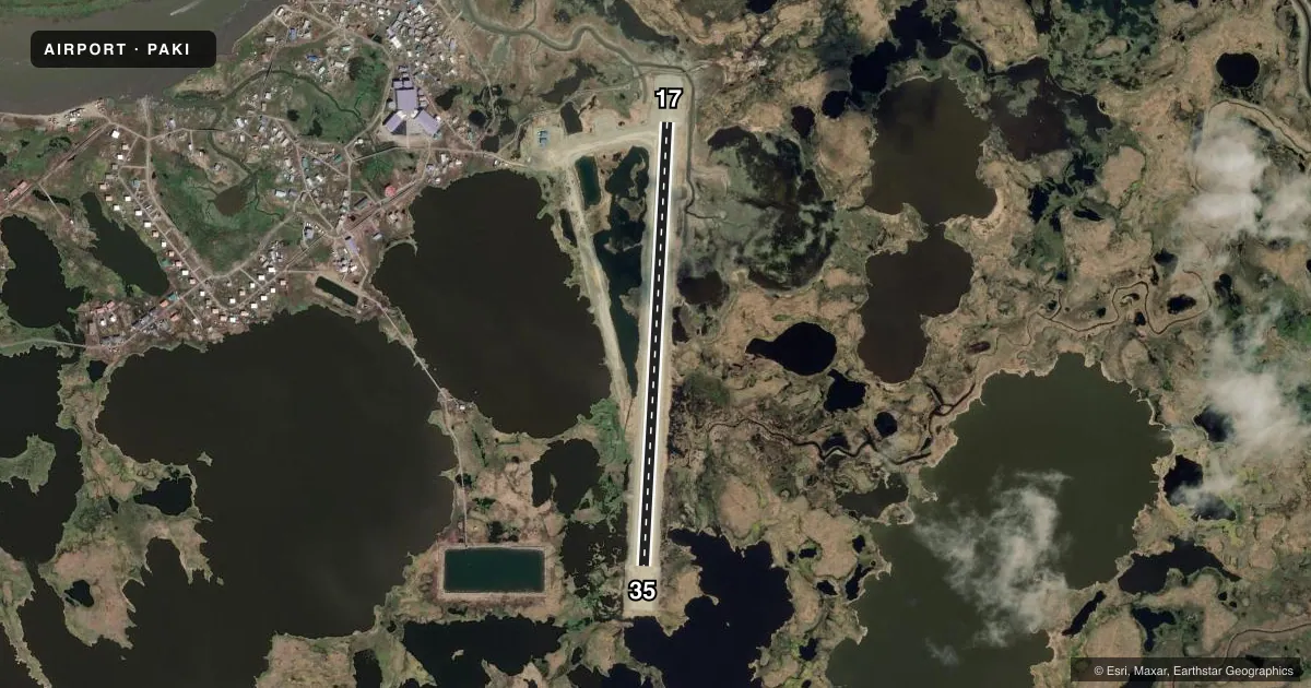
Runways & pattern
Full pagePattern entry · RWY 17
LEFT TRAFFICAirport sketch
Runways drawn to scale from FAA survey coordinates, rendered over satellite imagery. Not for navigation.
Approaches & charts
Services on the field
Fuel grades, oxygen, maintenance, ramp storage and lighting — as declared to the FAA by the airport operator.
Fuel & services
- Fuel
- Not available
Ramp & ground
- Transient storage
- Not published
- Landing fee
- No fee published
- Customs
- Not available
- Lighting schedule
- SEE RMK
- Wind indicator
- Lighted
- Segmented circle
- Yes
Fuel & FBOs
Cheapest 100LL and Jet A on the field and nearby. Always confirm with the FBO before taxi.
Airport notes
Surface conditions, obstructions, local procedures, lighting outages and other notes published with each FAA cycle.
General notes
- EXP FREQ XWINDS.
- BIRDS INVOF OF RWY.
- RWY COND UNMNT; RCMD VISUAL INSP BFR USE.
- TWY HAS DIPS & PONDING.
- UNLGTD WIND TURBINES 0.5 NM NW.
Lighting notes
- ACTVT MIRL RWY 17/35 - CTAF.
Runway surface & condition
- 17/35EMERG LGT - 907-896-5515.
Other notes
- UNRELBL.
- 17/35IREG.
VFR map & nearby airports
VFR sectional. Tap any ICAO chip to open that airport.
Key facts · PAKI
Answer card- ICAO
- PAKI
- Name
- KIPNUK
- Location
- KIPNUK, ALASKA
- Elevation
- 19.5 ft MSL
- Traffic pattern altitude
- 1,019.5 ft MSL (1,000 AGL)
- Control tower
- Non-towered (use CTAF)
- Total runways
- 1
- Longest runway
- 17/35 · 3,200 ft
- Published ILS approaches
- 0
- Published frequencies
- 1
- Magnetic variation
- 10°
- Current flight rules
- MVFR
- Current wind
- 190° at 12 kt
- Favored runway now
- RWY 17
Kipnuk Airport is in Kipnuk, Alaska. The field elevation is 19.5 ft MSL. It has one runway, 17/35, which is 3,200 ft long and gravel. The airport is not towered. CTAF is 122.7.
No ILS approaches are published here. The pattern altitude is not published, so use the standard 1,000 ft AGL for light piston operations unless current local guidance says otherwise. The runway headings are 183° and 3° magnetic. That matters here because the magnetic variation is 10°.
There are no on-field FBOs listed in the facts. Check with the airport operator or call the field directly before arrival if you need fuel or ground support. Published remarks say the runway lights on 17/35 are activated by CTAF. The runway surface is irregular. Runway condition is unmonitored, so a visual inspection before use is a good idea. Expect frequency crosswinds. Birds are in the vicinity of the runway. The taxiway has dips and ponding. There are also unlighted wind turbines about 0.5 NM northwest. The wind indicator is unreliable, so do not rely on it alone for the landing decision.