METAR & TAF PAAJ
PAAJ does not publish a METAR.
Showing the nearest reporting station: PANA (NAPAKIAK) · 28.5 NM away. Conditions at PAAJ may differ.
METAR · PANA
Observed 20:56Z
PANA 122056Z AUTO 07003KT 9SM SCT043 BKN055 OVC065 M13/M19 A3028 RMK AO2 SLP254 60000 T11331189 53000 FZRANO TSNO
- Wind
- 070° @ 3 kt
- Visibility
- 9 SM
- Temp / Dew
- -13°C / -19°C
- Altimeter
- 30.28 inHg
- Clouds
- OVC
- Density alt
- -3,787 ft
- Ceiling
- 5,500 ft AGL
- Rules
- VFR
Airport info & contacts
Manager on record, flight service, ARTCC, attendance schedule and pattern altitude — published by the FAA and refreshed every 28 days.
Location
- From city
- 1 NM NE
- VFR sectional
- BETHEL
- ARTCC
- ZAN · ANCHORAGE
- NOTAM facility
- ENA (NOTAM-D)
Airport manager
- Name
- JOSEPH LARAUX
- Phone
- (907) 543-2498
- Address
- PO BOX 505, BETHEL AK 99559
Flight service · Hours
- FSS ENA
- KENAI907-283-72111-866-864-1737
- Attendance
- Unattended
Frequencies
Tap any row to copy the frequency to your clipboard.
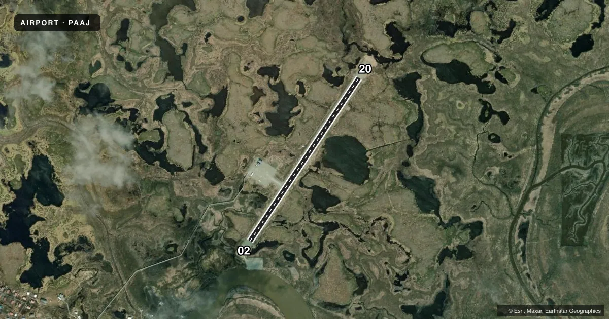
Runways & pattern
Full pagePattern entry · RWY 02
LEFT TRAFFICRunway end performance
| End | TORA | TODA | ASDA | LDA | VGSI | Approach lights | Obstruction |
|---|---|---|---|---|---|---|---|
| 02 | — | — | — | — | — | — | 6', brush, 36' from thr, 65' R of cntrln, slope 6 |
| 20 | — | — | — | — | — | — | 4', brush, 5' from thr, 68' R of cntrln, slope 1 |
Declared distances in feet. TORA = takeoff run available, TODA = takeoff distance, ASDA = accelerate-stop, LDA = landing distance.
Airport sketch
Runways drawn to scale from FAA survey coordinates, rendered over satellite imagery. Not for navigation.
Approaches & charts
Services on the field
Fuel grades, oxygen, maintenance, ramp storage and lighting — as declared to the FAA by the airport operator.
Fuel & services
- Fuel
- Not available
Ramp & ground
- Transient storage
- Not published
- Landing fee
- No fee published
- Customs
- Not available
- Lighting schedule
- SEE RMK
- Beacon schedule
- SS-SR
- Beacon
- White / Green (civil land)(WG)
- Wind indicator
- Lighted
- Segmented circle
- Yes
Fuel & FBOs
Cheapest 100LL and Jet A on the field and nearby. Always confirm with the FBO before taxi.
Airport notes
Surface conditions, obstructions, local procedures, lighting outages and other notes published with each FAA cycle.
General notes
- RWY COND UNMNT; RCMD VISUAL INSP BFR USE.
- WX CAMERA AVBL ON INTERNET AT HTTPS://WEATHERCAMS.FAA.GOV
- BIRDS ON & INVOF ARPT.
- MULT 120 FT UNLGTD WIND GENERATORS NEAR RIVER.
Lighting notes
- ACTVT MIRL RWY 02/20 - CTAF.
Approach & departure obstructions
- 02CONES & REFLECTIVE MKRS.
- 20CONES & REFLECTIVE MKRS.
Other notes
- UNRELBL.
VFR map & nearby airports
VFR sectional. Tap any ICAO chip to open that airport.
Key facts · PAAJ
Answer card- ICAO
- PAAJ
- Name
- TUNTUTULIAK
- Location
- TUNTUTULIAK, ALASKA
- Elevation
- 16 ft MSL
- Traffic pattern altitude
- 1,016 ft MSL (1,000 AGL)
- Control tower
- Non-towered (use CTAF)
- Total runways
- 1
- Longest runway
- 02/20 · 3,005 ft
- Published ILS approaches
- 0
- Published frequencies
- 1
- Magnetic variation
- 12°
- Current flight rules
- VFR
- Current wind
- 070° at 3 kt
- Favored runway now
- RWY 02
Tuntutuliak Airport sits in Tuntutuliak, Alaska. Field elevation is 16 ft MSL. The airport has one runway. Runway 02/20 is 3,005 ft long and gravel. There is no control tower. CTAF is 122.7.
No ILS approaches are published here. Pattern altitude is not published, so use the standard 1,000 ft AGL for light piston ops unless the current Chart Supplement says otherwise. Runway 02/20 has medium intensity lights that are activated by CTAF. Runway 02 and Runway 20 both have cones and reflective markers. The wind indicator is unreliable. Runway condition is unmonitored, so a visual inspection before landing is a good idea.
There are no on-field FBOs listed. Birds are reported on and near the airport. Multiple 120-foot unlighted wind generators are near the river. That matters on approach and in the pattern. The airport is in Alaska with low field elevation, so weather and surface conditions can change fast. Check the current Chart Supplement and get a look at the runway before committing, especially if you are arriving at night or in marginal visibility.