METAR & TAF KVCB
Current METAR
Observed 01:53Z
KVCB 120153Z AUTO VRB05KT 10SM CLR 37/08 A2973 RMK AO2 SLP066 T03670083
- Wind
- VAR @ 5 kt
- Visibility
- 10 SM
- Temp / Dew
- 37°C / 8°C
- Altimeter
- 29.73 inHg
- Clouds
- CLR
- Density alt
- 3,020 ft
- Ceiling
- Unlimited
- Rules
- VFR
Airport info & contacts
Manager on record, flight service, ARTCC, attendance schedule and pattern altitude — published by the FAA and refreshed every 28 days.
Location
- From city
- 2 NM NE
- VFR sectional
- SAN FRANCISCO
- ARTCC
- ZOA · OAKLAND
- NOTAM facility
- VCB (NOTAM-D)
Airport manager
- Name
- CATHERINE MCKENZIE COOK
- Phone
- 707-469-4603
- Address
- 301 COUNTY AIRPORT ROAD, SUITE 205, VACAVILLE CA 95688
Flight service · Hours
- FSS RIU
- RANCHO MURIETA1-800-WX-BRIEF
- Attendance
- MON-FRI · 1400-0100Z++
Frequencies
Tap any row to copy the frequency to your clipboard.
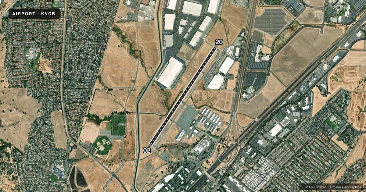
Runways & pattern
Full pagePattern entry · RWY 02
LEFT TRAFFICRunway end performance
| End | TORA | TODA | ASDA | LDA | VGSI | Approach lights | Obstruction |
|---|---|---|---|---|---|---|---|
| 02 | — | — | — | — | PAPI 2-box left(3.75°) | — | 52', tree, 1450' from thr, 200' R of cntrln, slope 25 |
| 20 | — | — | — | — | PAPI 2-box left(3.75°) | — | — |
Declared distances in feet. TORA = takeoff run available, TODA = takeoff distance, ASDA = accelerate-stop, LDA = landing distance.
Airport sketch
Runways drawn to scale from FAA survey coordinates, rendered over satellite imagery. Not for navigation.
Approaches & charts
Services on the field
Fuel grades, oxygen, maintenance, ramp storage and lighting — as declared to the FAA by the airport operator.
Fuel & services
- Fuel
- 100LLA
- Oxygen (bottled)
- Not available
- Oxygen (bulk)
- Not available
- Airframe repair
- Major
- Power plant repair
- Major
- Other services
- INSTR,RNTL,SALES
Ramp & ground
- Transient storage
- Tie-down
- Landing fee
- No fee published
- Customs
- Not available
- Lighting schedule
- SEE RMK
- Beacon schedule
- SS-SR
- Beacon
- White / Green (civil land)(WG)
- Wind indicator
- Lighted
- Segmented circle
- Yes
Fuel & FBOs
Cheapest 100LL and Jet A on the field and nearby. Always confirm with the FBO before taxi.
Airport notes
Surface conditions, obstructions, local procedures, lighting outages and other notes published with each FAA cycle.
General notes
- NO TURNS TO XW BLW 800 FT MSL; RMN W OF INSTA HWY FOR RWY 20, NOISE SENSITIVE AREA W OF ARPT.
- TWY LGTS ON PARL TWY ONLY.
- RWY 02 CALM WIND RWY.
- FOR CD CTC TRAVIS APCH AT 707-424-5111.
- WHEN APCHG & OPRG NEAR FUEL ISLAND, PILOTS EXER CTN, FLW YELLOW TAXI LINES, DRCTNL ARROWS, & POSTED SIGNAGE TO MINIMIZE IMPACT ON NEARBY HNGRS.
Lighting notes
- AFT 2200 ACTVT MIRL & PARALLEL TWY LGTS RY 02/20; PAPI & REIL RYS 02 & 20 - CTAF.
Other notes
- INCLUDES 2 GYROPLANES.
VFR map & nearby airports
VFR sectional. Tap any ICAO chip to open that airport.
Key facts · KVCB
Answer card- ICAO
- KVCB
- Name
- NUT TREE
- Location
- VACAVILLE, CALIFORNIA
- Elevation
- 116.6 ft MSL
- Traffic pattern altitude
- 1,116.6 ft MSL (1,000 AGL)
- Control tower
- Non-towered (use CTAF)
- Total runways
- 1
- Longest runway
- 02/20 · 4,700 ft
- Published ILS approaches
- 0
- Published frequencies
- 3
- Magnetic variation
- 13°
- Current flight rules
- VFR
- Current wind
- 000° at 5 kt
- Favored runway now
- RWY 02
Nut Tree Airport sits in Vacaville, California. Field elevation is 116.6 ft MSL. The airport has one runway. Runway 02/20 is 4,700 ft asphalt, which is the longest runway on the field. There is no control tower. Clearance delivery is handled through Travis Approach, with the published contact number in the Chart Supplement. No ILS approaches are published here.
Pattern altitude is not published. Use 1,000 ft AGL as the standard light piston pattern reference unless the current Chart Supplement says otherwise. The published remarks matter here. Taxiway lighting is on the parallel taxiway only. After 2200, medium intensity runway lights and the parallel taxiway lights come on for runway 02/20. PAPI and REIL for runways 02 and 20 are controlled by CTAF. Runway 02 is the calm wind runway. For runway 20, remain west of Interstate Highway because of the noise sensitive area west of the airport.
Nut Tree Airport has one on-field FBO, Nut Tree Airport. It carries 100LL, Jet A and Jet A Prist. Pilots should use caution near the fuel island. Follow the yellow taxi lines, directional arrows and posted signs. The field also has two gyroplanes, so expect mixed traffic. This is a low-elevation airport. The nearby highway, noise-sensitive area and CTAF-controlled lighting make a careful arrival brief worthwhile.