METAR & TAF O69
Current METAR
Observed 03:15Z
KO69 120315Z AUTO 33004KT 10SM CLR 22/12 A2977 RMK A01
- Wind
- 330° @ 4 kt
- Visibility
- 10 SM
- Temp / Dew
- 22°C / 12°C
- Altimeter
- 29.77 inHg
- Clouds
- CLR
- Density alt
- 1,138 ft
- Ceiling
- Unlimited
- Rules
- VFR
Airport info & contacts
Manager on record, flight service, ARTCC, attendance schedule and pattern altitude — published by the FAA and refreshed every 28 days.
Location
- From city
- 1 NM NE
- VFR sectional
- SAN FRANCISCO
- ARTCC
- ZOA · OAKLAND
- NOTAM facility
- OAK (NOTAM-D)
Airport manager
- Name
- DANIEL COHEN
- Phone
- 707-778-4404
- Address
- 601 SKY RANCH DRIVE, PETALUMA CA 94954
Flight service · Hours
- FSS OAK
- OAKLAND1-800-WX-BRIEF
- Attendance
- 0800-1700
Frequencies
Tap any row to copy the frequency to your clipboard.
Runways & pattern
Full pagePattern entry · RWY 29
RIGHT TRAFFICRunway end performance
| End | TORA | TODA | ASDA | LDA | VGSI | Approach lights | Obstruction |
|---|---|---|---|---|---|---|---|
| 11 | — | — | — | — | — | — | 65', trees, 2500' from thr, 150' R of cntrln, slope 35 |
| 29 | — | — | — | — | PAPI 4-box left(3°) | — | — |
Declared distances in feet. TORA = takeoff run available, TODA = takeoff distance, ASDA = accelerate-stop, LDA = landing distance.
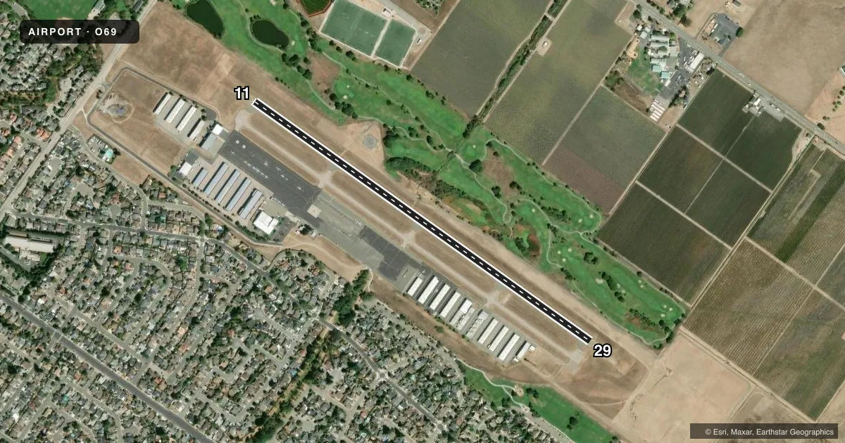
Airport sketch
Runways drawn to scale from FAA survey coordinates, rendered over satellite imagery. Not for navigation.
Approaches & charts
Services on the field
Fuel grades, oxygen, maintenance, ramp storage and lighting — as declared to the FAA by the airport operator.
Fuel & services
- Fuel
- 100LLA
- Oxygen (bottled)
- HIGH/LOW
- Oxygen (bulk)
- Low pressure
- Airframe repair
- Major
- Power plant repair
- Major
- Other services
- INSTR,RNTL,SALES
Ramp & ground
- Transient storage
- Tie-down
- Landing fee
- No fee published
- Customs
- Not available
- Lighting schedule
- SEE RMK
- Beacon schedule
- SS-SR
- Beacon
- White / Green (civil land)(WG)
- Wind indicator
- Lighted
- Segmented circle
- Yes
Fuel & FBOs
Cheapest 100LL and Jet A on the field and nearby. Always confirm with the FBO before taxi.
Airport notes
Surface conditions, obstructions, local procedures, lighting outages and other notes published with each FAA cycle.
General notes
- NOISE ABATEMENT PROCEDURE 800 FT MSL BEFORE CROSSWIND TURN; STRAIGHT OUT CLIMB TO 1500 FT MSL FOR DEPS; DOWNWIND STAY OUTSIDE ADOBE RD; AVOID OVERFLIGHTS OF THE OLD ODOBE HISTORIC PARK.
- FOR CD CTC OAKLAND ARTCC AT 510-745-3380.
- CALM WIND RWY 29.
Lighting notes
- ACTVT REIL RWY 29; PAPI RWY 29; MIRL RWY 11/29 - CTAF.
VFR map & nearby airports
VFR sectional. Tap any ICAO chip to open that airport.
Key facts · O69
Answer card- ICAO
- O69
- Name
- PETALUMA MUNI
- Location
- PETALUMA, CALIFORNIA
- Elevation
- 90.2 ft MSL
- Traffic pattern altitude
- 1,090.2 ft MSL (1,000 AGL)
- Control tower
- Non-towered (use CTAF)
- Total runways
- 1
- Longest runway
- 11/29 · 3,600 ft
- Published ILS approaches
- 0
- Published frequencies
- 2
- Magnetic variation
- 16°
- Current flight rules
- VFR
- Current wind
- 330° at 4 kt
- Favored runway now
- RWY 29
Petaluma Muni sits in Petaluma, California. Field elevation is 90.2 ft MSL. The airport has one runway, 11/29, which is 3,600 ft long and paved with asphalt. There is no control tower. CTAF and UNICOM are both 122.7. No ILS approaches are published here.
Pattern altitude is not published. Use the standard 1,000 ft AGL for light piston operations unless the current Chart Supplement says otherwise. The airport uses a noise abatement procedure. Keep the crosswind turn at 800 ft MSL. Departures should climb straight out to 1,500 ft MSL. On downwind, stay outside Adobe Road. Avoid overflights of Old Adobe Historic Park.
Runway 29 has runway end identifier lights, a PAPI and medium intensity runway lights. Runways 11 and 29 are lit. Calm wind runway is 29. If you need fuel or local help, Petaluma Municipal Airport is on the field. It carries 100LL, Jet A and Jet A Prist. For clearance delivery, Oakland ARTCC handles it by phone. This is a low-elevation field with nearby noise-sensitive areas, so brief the departure and pattern work before you taxi.